Cloud chambers were one of the first methods used to study radioactive decay and cosmic particles. Such chambers are filled with a cool, supersaturated cloud of alcohol vapor. When high-energy particles pass through, they collide with atoms in the chamber, ionizing them. Those ions then serve as nucleation sites for the alcohol vapor, creating a condensation streak that marks the particle’s passage. In some respects, they’re similar to the contrails that form behind airplanes. What you’re seeing is not the particle itself but evidence that it went by. YouTuber Nick Moore built his own cloud chamber. Learn more about it and see lots more great footage of it in action in the full video below. (Image and video credit: N. Moore)
Tag: condensation

The Drinking Bird
At first glance, the drinking bird is a simple desk toy, but the physics and engineering behind the device is clever enough to have challenged many great minds. In this video, Bill Hammack dissects the drinking bird, revealing the heat engine beneath the felt and feathers. The bird’s drinking is driven by thermodynamics and the relative pressures of fluids in its head and body. When the beak is wetted, fluid wicks up the felted head and slowly evaporates, thereby cooling the vapor inside the head. Some of that vapor condenses, lowering the vapor pressure in the head and allowing liquid to rise from the body. When enough fluid reaches the head, the bird tips forward. This allows vapor to rise up the liquid column into the head, equalizing the pressure between the two ends. The bird sits up with a freshly wetted head and starts the cycle over. Check out the full video for more detail, including a look at what other methods can drive the bird, including bourbon and light bulbs. (Video and image credit: B. Hammack; via J. Ouellette)

“Breathe”


In black and white, the towering power of a thunderstorm looks almost apocalyptic. Photographer Mike Olbinski’s latest storm timelapse, “Breathe,” features roiling turbulence, distant downpours, and eerie mammatus clouds. Supercell thunderstorms churn and rotate over empty horizons. Billowing cumulus clouds condense from bright skies. Flashes of lightning reveal the outlines of massive thunderheads. It’s a beautiful glimpse of atmospheric fluid dynamics in action, with every texture magnified and enhanced by the stark black and white palette. (Video and image credit: M. Olbinski; via Gizmodo)
Jumping Droplets
Condensation, which removes heat by changing a vapor into a liquid, is a common feature in industrial heat transfer. When droplets form on surfaces, they typically have to grow to millimeter size before gravity causes them to slide off and open up the surface to new droplet formation. Hydrophobic surfaces can shed droplets a little sooner. Droplets only 100 micrometers in size will spontaneously jump off hydrophobic surfaces due to the release of excess surface energy during droplet coalescence, but this only happens when those droplets have a small contact area with the surface. Defects in the nanoscale structure of the surface can allow water to squeeze in between posts and hold on.
To counter this, new experiments packed copper nanowires into a dense 3D array. This permits fewer defects and helps condensing droplets leap from the surface sooner. Each droplet carries away a bit of the surface’s heat. The new method is impressively efficient at it. Researchers found the new heat exchanger could remove 100% more heat than previous hydrophobic designs. (Video credit: Science; research credit: R. Wen et al.)
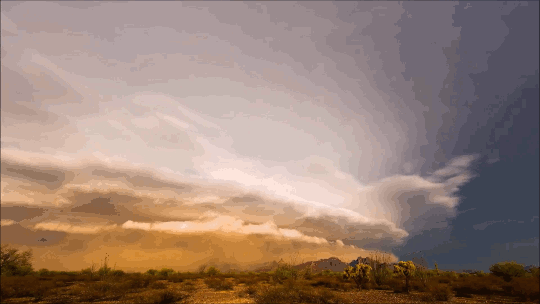
“Monsoon IV”
It’s a cliché to claim that the sky is bigger in the American West, but the wide, open views in that region do offer a very different perspective on weather. Photographer Mike Olbinski’s works give viewers a taste of that perspective of far-off thunderstorms, towering anvil clouds, and massive downpours in the distance. At the same time, many of his sequences illustrate the birth and death of these massive storms. As warm, moist air rises, a puffy cumulus cloud (below) swells upward as fresh moisture condenses. When it reaches a thermal cap and can rise no further, precipitation begins to fall, dragging surrounding air with it. This is the mature stage of a storm, when both updrafts and downdrafts exist simultaneously.
Eventually, the storm’s power begins to wane as the downdrafts cut off the updrafts that feed the storm. Sometimes this occurs in a massive downdraft where cool air sinks straight down and, upon encountering the ground, spreads radially outward. In dry regions, this outward burst of ground-level winds can pick up dirt, dust, and sand, forming a wall-like haboob (below) that advances past the remains of the storm. Watch the entire video to see some examples in their full glory! (Video and image credit: M. Olbinski, source; via Rex W.)


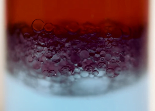
Emulsions By Condensation
Oil and water are hard to mix, as any salad dressing aficionado will attest. Technically, the two fluids are immiscible – they won’t mix with one another – but one way around this is to emulsify them by distributing droplets of one in the other. This is usually accomplished by shaking or using sound waves to vibrate the mixture, but the results are typically short-lived. The larger a droplet is, the more gravity affects it, causing the buoyant oil to rise and separate from the water.
The key to making an emulsion last is creating tiny droplets, which a new study accomplishes energy efficiently through condensation. Instead of mixing the oil and water immediately, the researchers used a surface covered in a mixture of oil and surfactant and cooled it in a humid chamber. As the temperature dropped, water condensed onto the oil and became encapsulated, creating nanoscale emulsion droplets. At such a tiny scale, buoyant forces are unable to overcome surface tension, so the emulsion remains stable for months. (Image credit: MIT, source; research credit: I. Guha et al.; via MIT News)

Lenticular Clouds
Lenticular clouds are peculiar enough that, for years, they’ve been mistaken for other things – often UFOs. These lens-shaped clouds tend to form near mountainous terrain, where air gets forced up and over the topology. If there’s a drop in temperature as the air rises, water can condense out to form the cloud. Once the air sinks, it warms enough that condensation is no longer possible. The result is a cloud that appears to stand still even though the air is moving. In reality, the cloud is constantly reforming from the moisture of incoming air. Lenticular clouds can form as a single layer, or they can form stacks like the one pictured above in Boulder, Colorado. They may seem odd, but they’re actually fairly common. If you live near hills or mountains, keep an eye out for them! (Image credit: @bayouowl; via Ilya L.)

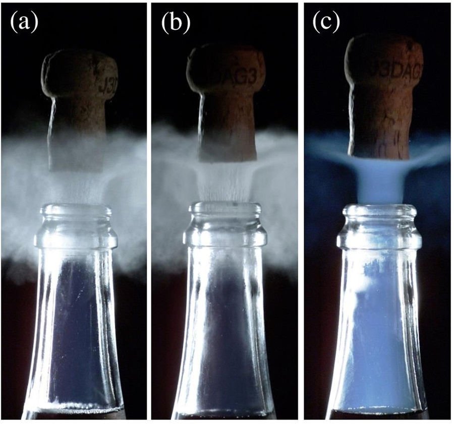
The Mist of Champagne
If you’ve ever popped open a chilled bottle of champagne, you’ve probably witnessed the gray-white cloud of mist that forms as the cork flies. Opening the bottle releases a spurt of high-pressure carbon dioxide gas, although that’s not what you see in the cloud. The cloud consists of water droplets from the ambient air, driven to condense by a sudden drop in temperature caused by the expansion of the escaping carbon dioxide. Scientifically speaking, this is known as adiabatic expansion; when a gas expands in volume, it drops in temperature. This is why cans of compressed air feel cold after you’ve released a few bursts of air.
If your champagne bottle is cold (a) or cool (b), the gray-white water droplet cloud is what you see. But if your champagne is near room temperature ( c ), something very different happens: a blue fog forms inside the bottle and shoots out behind the cork. To understand why, we have to consider what’s going on in the bottle before and after the cork pops.
A room temperature bottle of champagne is at substantially higher pressure than one that’s chilled. That means that opening the bottle makes the gas inside undergo a bigger drop in pressure, which, in turn, means stronger adiabatic expansion. Counterintuitively, the gas escaping the warm champagne actually gets colder than the gas escaping the chilled champagne because there’s a bigger pressure drop driving it. That whoosh of carbon dioxide is cold enough, in fact, for some of the gas to freeze in that rushed escape. The blue fog is the result of tiny dry ice crystals scattering light inside the bottleneck.
That flash of blue is only momentary, though, and the extra drop in temperature won’t cool your champagne at all. Liquids retain heat better than gases do. For more, on champagne physics check out these previous posts. (Image and research credit: G. Liger-Belair et al.; submitted by David H.)

Creating Clouds
Despite their ubiquity and importance, we know surprisingly little about how clouds form. The broad strokes of the process are known, but the details remain somewhat fuzzy. One challenge is understanding how nucleation – the formation of droplets that become clouds or rain – works. A recent laboratory experiment in an analog cloud chamber suggests that falling rain drops may help spawn more rain drops.
The experiment takes place in a chamber filled with sulfur hexafluoride and helium. The former acts like water in our atmosphere, appearing in both liquid and vapor forms, while the latter takes the place of dry components of our atmosphere, like nitrogen. The bottom of the chamber is heated, forming a liquid layer of sulfur hexafluoride, seen at the bottom of the animation above. The top of the chamber is cooled, encouraging sulfur hexafluoride vapor to condense and form droplets that fall like rain. A top view of the same apparatus during a different experiment is shown in this previous post.
When droplets fall through the chamber, their wakes mix cold vapor from near the drop with warmer, ambient vapor. This changes the temperature and saturation conditions nearby and kicks off the formation of microdroplets. These are the cloud of tiny black dots seen above. Under the right conditions, these microdroplets grow swiftly as more vapor condenses onto them. In time, they grow heavy enough to fall as rain drops of their own. (Image credits: P. Prabhakaran et al.; via APS Physics; submitted by Kam-Yung Soh)
“Pursuit”
Photographer Mike Olbinski has released yet another breathtaking timelapse film of weather over the Great Plains. This one has a little bit of everything: storms, tornadoes, incredible cloud formations, and even sunny days. Olbinski’s work is a reminder that there’s a constant beautiful drama playing out over our heads if we just take the time to watch. Under blue skies, condensation and turbulence are building towering mountains, and even when the sky is gray, it can be churning like the ocean just over your head. The U.S. Great Plains may be home to particularly dramatic examples of this behavior (thanks largely to the atmospheric influence of the Rocky Mountains), but these same phenomena are going on all the time overhead. (Video and image credits: M. Olbinski)