The intense heat from wildfires fuels updrafts, lifting smoke and vapor into the atmosphere. As the plume rises, water vapor cools and condenses around particles (including ash particles) to form cloud droplets. Eventually, that creates the billowing clouds we see atop the smoke. These pyrocumulus clouds, like this one over California’s Line fire in early September 2024, can develop further into full thunderstorms, known in this case as pyrocumulonimbus. The storm from this cloud included rain, strong winds, lightning, and hail. Unfortunately, storms like these can generate thousands of lightning strikes, feeding into the wildfire rather than countering it. (Image credit: L. Dauphin; via NASA Earth Observatory)
Tag: updrafts

Pelican Surfing
Birds can be incredibly clever about using their surroundings to enhance their flight. Pelicans will even surf! As a line of waves rolls toward shore, it pushes a small updraft ahead of it – just like a line of mountains creates a windy updraft. Pelicans save energy by riding the updraft just like a surfer would ride the swell. Once the wave breaks, the air and water become turbulent and less useful, so the pelican cuts away to find his next ride. (Image and submission credit: N. Yarvin, source)

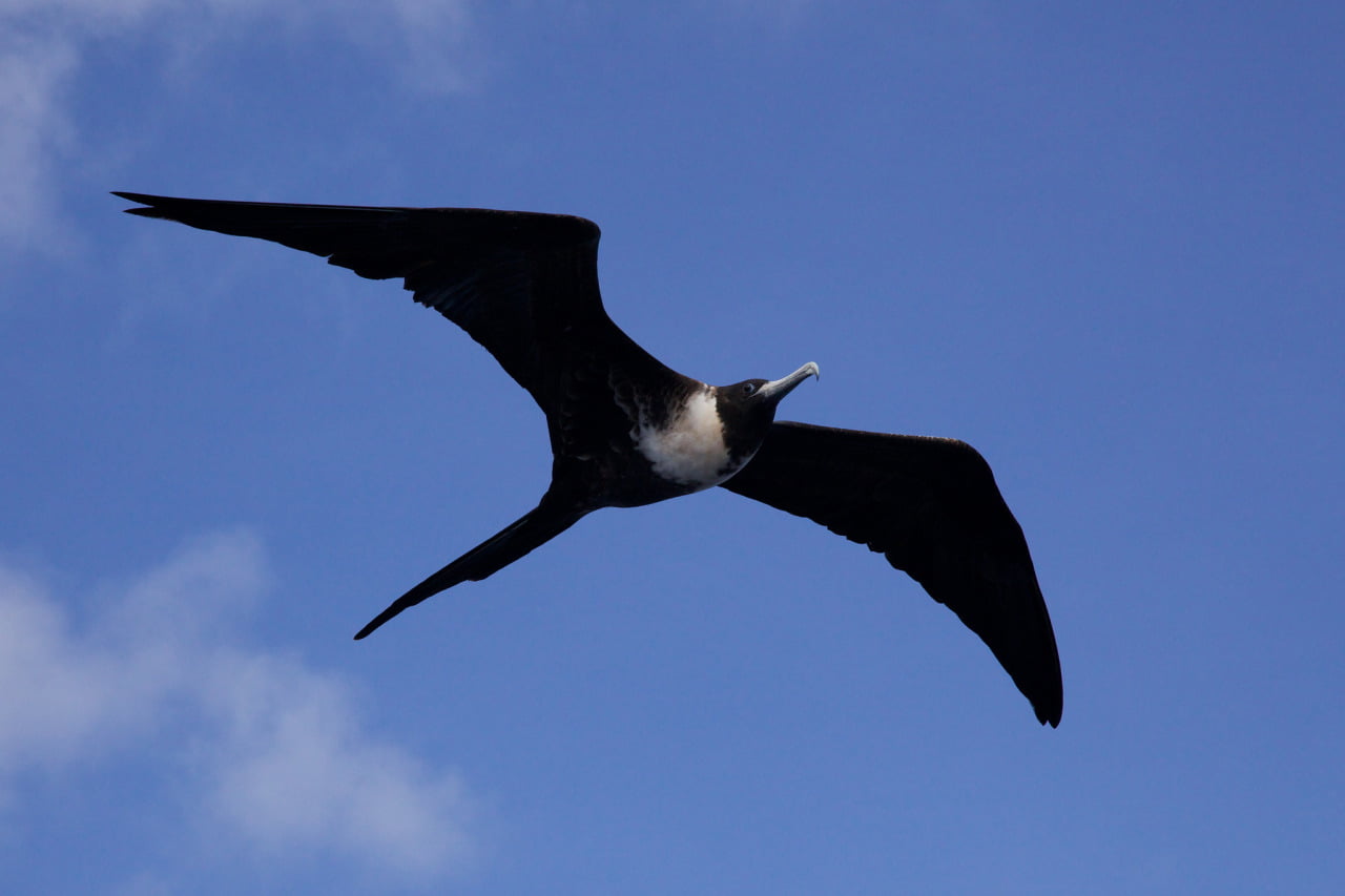
The Seabird That Can’t Get Wet
Unlike most seabirds, the frigatebird does not have waterproof feathers. Landing in the water during a transoceanic flight would quickly drown the bird, so instead they stay aloft. But until recently, scientists did not realize just how adept the birds are. Studying tagged frigatebirds in flight, researchers found that the birds could reach altitudes of 4000 meters and that they could soar without flapping for up to 64 kilometers! They achieve these heights by seeking out clouds, which mark strong atmospheric updrafts. The birds ride these thermals up to the cloud tops – well into freezing conditions – and then glide slowly back down.
Their bodies are impressively built for slow glides. Frigatebirds boast a low body weight for their large wing area. This ratio is known as wing loading, and it’s a fundamental characteristic of any flier, avian or otherwise. Low wing loading is key to gliding longer because it reduces the speed at which a glider loses altitude. (Image credit: D. Brossard; research credit: H. Weimarskirch et al.; via @skunkbear)
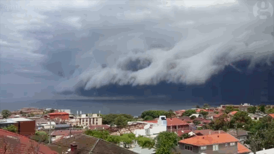
Shelf Cloud
Sydney, Australia was treated to a spectacular meteorological show over the weekend when an impressive shelf cloud swept over the city. These timelapses show the dramatic leading edge of the incoming thunderstorm. Notice how the cloud streams upward along the shelf. The storm is driven by this updraft of warm moist air, which rises until it is capped by the troposphere. At this point, the air spreads, creating an anvil-like shape, and cools. The moisture drawn up at the storm’s front will condense, freeze, and fall as rain or hail. When the updraft weakens, the storm will be dominated by the downdraft of the falling precipitation and eventually peter out. (Image credit: W. Reed and H. Vann, source; via J. Hertzberg)

Supercell Thunderstorm
Photographer Mike Olbinski has captured a spectacular timelapse of a supercell thunderstorm over the plains of Texas. Supercells are characterized by a strong, rotating updraft known as a mesocyclone, seen clearly in the video. These storms are commonly isolated occurrences, forming when horizontal vorticity in the form of wind shear is redirected upwards by an updraft. Such a strong updraft is typically created by a capping inversion, a situation where a layer of warmer air traps the colder air beneath it. (This is why one sees a distinctive cut-off at the top of some clouds.) As warm air rises from the surface, either the air above the cap will cool or the air below the cap will warm. Either situation results in an instability with cooler air on top of warmer air, providing a catalyst for the kind of dramatic weather seen here. (Video credit: M. Olbinski; via io9)