It’s time for another storm-chasing timelapse from photographer Mike Olbinski! “Vorticity 6” focuses on supercell thunderstorms and their tornadoes. There’s billowing turbulent convection, undulating asperitas, bulging mammatus, microbursts, and more. There’s nothing like timelapse to highlight the growth, rotation, and shear involved in these storms. (Video and image credit: M. Olbinski)
Tag: mammatus
Ominous Mammatus
Mammatus clouds are fairly unusual and often look quite dramatic. Most clouds have flat bottoms, caused by the specific height and temperature at which their droplets condense. But mammatus clouds have bubble-like bottoms that are thought to form when large droplets of water or ice sink as they evaporate. Although they can occur in the turbulence caused by a thunderstorm, mammatus clouds themselves are not a storm cloud. They appear in non-stormy skies, too. The clouds are particularly striking when they’re lit from the side, as in the image above. (Image credit: J. Olson; via APOD)
Asperitas Formation
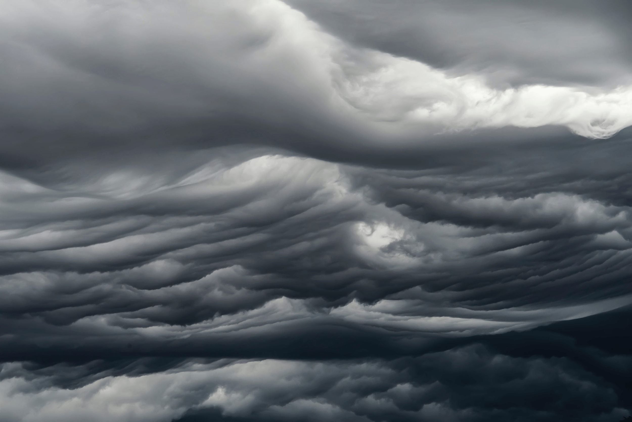
In 2017, the World Meteorological Organization named a new cloud type: the wave-like asperitas cloud. How these rare and distinctive clouds form is still a matter of debate, but this new study suggests that they need conditions similar to those that produce mammatus clouds, plus some added shear.
Using direct numerical simulations, the authors studied a moisture-filled cloud layer sitting above drier ambient air. Without shear, large droplets in this cloud layer slowly settle downward. As the droplets evaporate, they cool the area just below the cloud, changing the density and creating a Rayleigh-Taylor-like instability. This is one proposed mechanism for mammatus clouds, which have bulbous shapes that sink down from the cloud.
When they added shear to the simulation, the authors found that instead of mammatus clouds, they observed asperitas ones. But the amount of shear had to be just right. Too little shear produced mammatus clouds; too much and the shear smeared out the sinking lobes before they could form asperitas waves. (Image credit: A. Beatson; research credit: S. Ravichandran and R. Govindarajan)
“Shadows in the Sky”
This moody music video features storm chasing footage from photographer Mike Olbinski. As always, his captures are stunningly majestic. Watch closely and you’ll see everything from bulbous mammatus clouds to powerful microbursts, from horizon-obscuring haboobs to sky-splitting lightning. And if this video isn’t enough, there’s plenty more to enjoy. (Video and image credit: M. Olbinski)
Stormy Landscapes
Photographer Mitch Dobrowner captures the power of major storm systems across the western United States and Canada in these dramatic black-and-white images. Misty clouds, massive downpours, bulbous mammatus clouds, and lonely landscapes abound. You can find more of his work on his website and Instagram. (Image credit: M. Dobrowner; via Colossal)
“Monsoon 6”
The stunning power and beauty of our atmosphere comes to life in Mike Olbinski’s latest short film, “Monsoon 6”. Over the years, I’ve probably watched dozens of Olbinski’s videos, yet he still captures sequences that make me exclaim aloud as I watch. In this one, some of my favorites are the microburst at 2:17 and the development of mammatus clouds at 3:20. How mammatus clouds form is still very much an area of active research; I don’t know if Olbinski’s footage sheds light on their formation, but it is supremely awesome to watch! (Image and video credit: M. Olbinski)
“Vorticity 3”
Mike Olbinski’s “Vorticity 3” is a stunning view of storm chasing in the American West. I’ve learned after years in Colorado to always look up because dramatic skies are common here, as is seeing rain falling miles away. Olbinski’s film captures all of that grandeur and more, giving all of us a glimpse inside the incredible storms that mark the summer months in this region. You’ll see spinning supercell thunderstorms, bulbous mammatus clouds, towering cumulus clouds, and more. (Video and image credit: M. Olbinski)
Mammatus Clouds
Mammatus clouds are a relatively rare and dramatic variety. One advantage of living in Colorado is that I see them somewhat often, especially during our stormy springs and summers. This video by Mike Olbinski features a dramatic skyscape of mammatus clouds (here in Colorado, natch) at sunset.
Although they’re often associated with stormy weather, there’s no widely accepted theory as to how mammatus clouds form. Their lobe-like protrusions form from cold, sinking air, but this is about as far as theories agree. It’s even unclear what their relation to extreme weather may be since these short-lived cloud formations can appear around, before, or even after such weather. (Image and video credit: M. Olbinski)
“Breathe”
In black and white, the towering power of a thunderstorm looks almost apocalyptic. Photographer Mike Olbinski’s latest storm timelapse, “Breathe,” features roiling turbulence, distant downpours, and eerie mammatus clouds. Supercell thunderstorms churn and rotate over empty horizons. Billowing cumulus clouds condense from bright skies. Flashes of lightning reveal the outlines of massive thunderheads. It’s a beautiful glimpse of atmospheric fluid dynamics in action, with every texture magnified and enhanced by the stark black and white palette. (Video and image credit: M. Olbinski; via Gizmodo)
“Pursuit”
Photographer Mike Olbinski has released yet another breathtaking timelapse film of weather over the Great Plains. This one has a little bit of everything: storms, tornadoes, incredible cloud formations, and even sunny days. Olbinski’s work is a reminder that there’s a constant beautiful drama playing out over our heads if we just take the time to watch. Under blue skies, condensation and turbulence are building towering mountains, and even when the sky is gray, it can be churning like the ocean just over your head. The U.S. Great Plains may be home to particularly dramatic examples of this behavior (thanks largely to the atmospheric influence of the Rocky Mountains), but these same phenomena are going on all the time overhead. (Video and image credits: M. Olbinski)