Nothing showcases the incredible power of our atmosphere like storms, and no one does stormchase photography like Mike Olbinski. In this vignette, he shows a stunning line of supercells caught near sunset on July 17, 2022. The high shear–combined with the setting sun–put on an incredible show. Dust blown up in a haboob, microbursts and downpours in the distance, and lots of churning, roiling turbulence. (Video and image credit: M. Olbinski)
Photographer and stormchaser extraordinaire Mike Olbinski is back with the fifth volume in his “Vorticity” series. Shot over the 2022 and 2023 tornado seasons in the U.S. Central Plains, this edition has virtually everything: supercells, microbursts, lightning, tornadoes, and haboobs. There’s towering convection and churning, swirling turbulence. It’s a spectacular look at the power and grandeur of our atmosphere. (Video and image credit: M. Olbinski)
Today, enjoy this moody black-and-white short film of storm timelapses. Photographer Mike Olbinski is a master of this subject. I never tire of watching his towering convective supercell thunderstorms or his picturesque microbursts. The lightning-lit clouds in the latter half of the film are particularly spectacular (assuming you do not have sensitivities to flashing lights). And there are a few haboobs and a tornado in there for good measure, too. (Image and video credit: M. Olbinski)
This moody music video features storm chasing footage from photographer Mike Olbinski. As always, his captures are stunningly majestic. Watch closely and you’ll see everything from bulbous mammatus clouds to powerful microbursts, from horizon-obscuring haboobs to sky-splitting lightning. And if this video isn’t enough, there’s plenty more to enjoy. (Video and image credit: M. Olbinski)
Photographer Mitch Dobrowner captures the power of major storm systems across the western United States and Canada in these dramatic black-and-white images. Misty clouds, massive downpours, bulbous mammatus clouds, and lonely landscapes abound. You can find more of his work on his website and Instagram. (Image credit: M. Dobrowner; via Colossal)
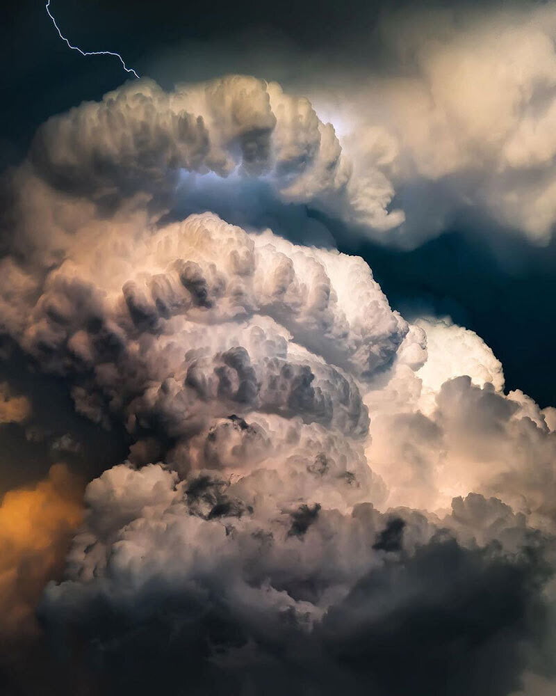
Towering mountains of convection and ominous colors are staples of Adam Kyle Jackson’s storm photography. His dramatic portraits of supercell thunderstorms highlight the majesty and power of these turbulent phenomena. Make sure to follow him on Instagram for lots more! (Image credit: A. Jackson; via Nat Geo)
Tornadoes are some of the most powerful storms on Earth. Their difficult-to-predict nature means that we still have a relatively scant understanding of exactly how they form. We know the conditions that promote their development — warm, moist rising air, wind shear, and rotation — but how and when those translate into a dangerous funnel cloud is harder to pin down. In this video, we hear from one of National Geographic’s storm researchers, Anton Seimon, who chases these storms in search of answers. (Image and video credit: National Geographic)
The stunning power and beauty of our atmosphere comes to life in Mike Olbinski’s latest short film, “Monsoon 6”. Over the years, I’ve probably watched dozens of Olbinski’s videos, yet he still captures sequences that make me exclaim aloud as I watch. In this one, some of my favorites are the microburst at 2:17 and the development of mammatus clouds at 3:20. How mammatus clouds form is still very much an area of active research; I don’t know if Olbinski’s footage sheds light on their formation, but it is supremely awesome to watch! (Image and video credit: M. Olbinski)
Mike Olbinski’s “Vorticity 3” is a stunning view of storm chasing in the American West. I’ve learned after years in Colorado to always look up because dramatic skies are common here, as is seeing rain falling miles away. Olbinski’s film captures all of that grandeur and more, giving all of us a glimpse inside the incredible storms that mark the summer months in this region. You’ll see spinning supercell thunderstorms, bulbous mammatus clouds, towering cumulus clouds, and more. (Video and image credit: M. Olbinski)
Where cold and warm air meet, our atmosphere churns with energy. From the turbulence of supercell thunderclouds to the immense electrical discharge of lightning, there’s much that’s breathtaking about stormy skies. Photographer Dustin Farrell explores them, with a special emphasis on lightning, in his short film, “Transient 2″.
As seen in high-speed video, lightning strikes begin with tree-like leaders that split and spread, searching out the path of least resistance. Once that line from cloud to ground is discovered, electrons flow along a plasma channel that arcs from sky to earth. The estimated temperatures in the core of this plasma reach 50,000 Kelvin, far hotter than the Sun’s surface. It’s this heating that generates the blue-white glow of a lightning bolt. The heating also expands the air nearby explosively, producing the shock wave we hear as a crash of thunder. (Images and video credit: D. Farrell et al.; via Colossal)


.")
.")
.")
.")


