It’s time for another storm-chasing timelapse from photographer Mike Olbinski! “Vorticity 6” focuses on supercell thunderstorms and their tornadoes. There’s billowing turbulent convection, undulating asperitas, bulging mammatus, microbursts, and more. There’s nothing like timelapse to highlight the growth, rotation, and shear involved in these storms. (Video and image credit: M. Olbinski)
Tag: clouds

Cloud Convection on Titan
Saturn’s moon Titan is a fascinating mirror to our own planet. It’s the only other planetary body with surface-level liquid lakes and seas, but instead of water, Titan’s are made of frigid ethane and methane. Like Earth, Titan has a weather cycle that includes evaporation, condensation, and rain. And now scientists have made their first observations of clouds convecting in Titan’s northern hemisphere.
Using data from both the Keck Observatory and JWST, the team tracked clouds on Titan rising to higher altitudes, a critical step in the planet’s methane cycle. This translation took place over a period of days, giving scientists modeling the Saturnian moon new insight into the seasonal behaviors of Titan’s atmosphere. (Image credit: NASA/ESA/CSA/STScI; research credit: C. Nixon et al.; via Gizmodo)

Hole Punch Clouds
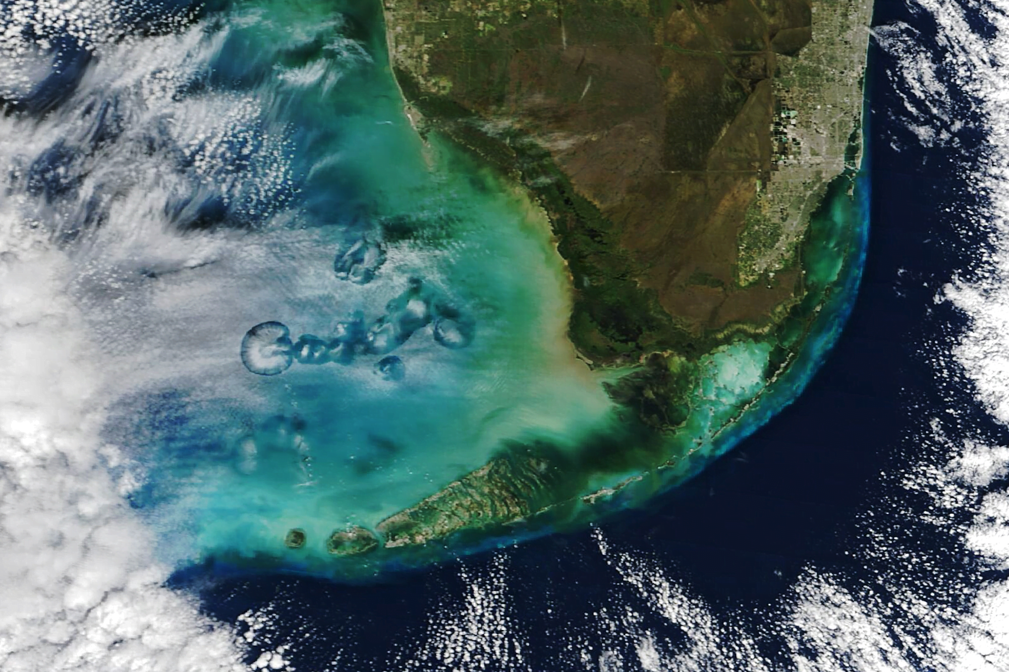
At times altocumulus cloud cover is pierced by circular or elongated holes, filled only with the wispiest of virga. These odd holes are known by many names: cavum, fallstreak holes, and hole punch clouds. Long-running debates about these clouds’ origins were put to rest some 14 years ago, after scientists showed they were triggered by airplanes passing through layers of supercooled droplets.
When supercooled, water droplets hang in the air without freezing, even though they are colder than the freezing point. This typically happens when the water is too pure to provide the specks of dust or biomass needed to form the nucleus of an ice crystal. But when an airplane passes through, the air accelerated over its wings gets even colder, dropping the temperature another 20 degrees Celsius. That is cold enough that, even without a nucleus, water drops will freeze. More and more ice crystals will form, until they grow heavy enough to fall, leaving behind a clear hole or wisps of falling precipitation.
In the satellite image above, flights moving in and out of Miami International Airport have left a variety of holes in the cloud cover each of them large enough to see from space! (Image credit: M. Garrison; research credit: A. Heymsfield et al. 2010 and A. Heymsfield et al. 2011; via NASA Earth Observatory)

The Real Butterfly Effect
The butterfly effect — that the flapping of a butterfly’s wings in Brazil can cause a tornado in Texas — expresses the sensitivity of a chaotic system to initial conditions. In essence, because we can’t possibly track every butterfly in Brazil, we’ll never perfectly predict tornadoes in Texas, even if the equations behind our weather forecast are deterministic.
But this interpretation doesn’t fully capture the subtleties of the situation. With fluid dynamics, the small scales of a flow — like the turbulence in an individual cloud — are linked to the largest scales in the flow — for example, a hurricane. For short times, we’re actually quite good at predicting those large scales; our weather forecasts can distinguish sunny days and cloudy ones a week out. But at smaller scales, the forecast errors pile up quickly. No one can forecast that an individual cloud will form over your house three days from now. And because the small scales are linked to the larger scales, the uncertainties from the small scale cascade upward, limiting how far into the future we can reliably predict the weather.
And, unfortunately, drilling down to capture smaller and smaller scales in our models can’t fix the problem, unless our initial uncertainties are identically zero. To get around this problem, weather forecasters instead use ensemble forecasting, where they run many simulations of the weather with slightly different initial conditions. Those differences in initial conditions let the forecasters play with those initial uncertainties — how accurate is the temperature reading from that station? How reliable is the instrument reporting that humidity? How old is the satellite data coming in? Once all the forecasts are run, they can see how many predicted sunny days versus rainy ones, which ones resulted in severe weather, and so on. Often the probabilities we see in our weather app — like 30% chance of rain — depend on factors including how many of the forecasts resulted in rain.
Unfortunately, this butterfly effect permanently limits just how far into the future we can predict weather — at least until we fully understand the nature of the Navier-Stokes equations. For much more on this interesting aspect of chaos, check out this Physics Today article. (Image credit: NASA; see also T. Palmer at Physics Today)

“Nimbus”
Ephemeral clouds drift through unusual places in artist Berndnaut Smilde‘s works. He creates his clouds from smoke and water, launching them for a matter of seconds before they dissipate. During that time, he and his collaborators take photographs of the clouds, creating a memento of a time already past. Catch more of Smilde’s short-lived weather on his website and Instagram. (Image credit: B. Smilde and collaborators; via Colossal)

Clouds Down Under
This large and unusual cloud formation was captured one July morning over western Australia. Stretching over 1,000 kilometers, the clouds have interesting features at both the large and small scale. The small-scale ripples within the clouds are gravity waves triggered by the terrain below. The larger, arced features are tougher to explain, though they may also be related to gravity waves and terrain, just on a much larger scale. They also resemble fallstreak clouds where supercooled droplets evaporate from the inside of the cloud out. (Image credit: W. Liang; via NASA Earth Observatory)

Jovian Swirls
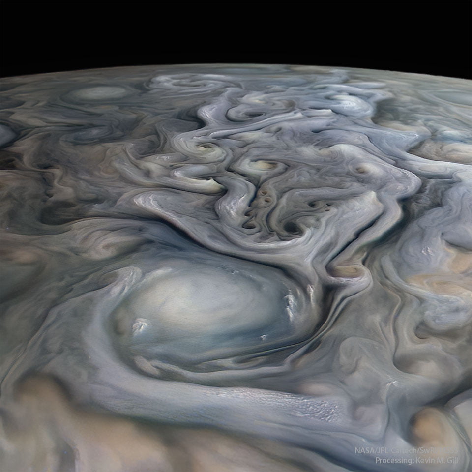
Jupiter, our solar system’s stormiest planet, shares many similarities with Earth. But where Earth’s strongest storms are cyclones centered on low-pressure regions, Jupiter’s longest and strongest storms are anti-cyclones, driven by areas of high pressure. They’re often massive — larger than the entire Earth — and persist for weeks, months, or years. This processed image comes from the JunoCam instrument and shows some of the incredible cloud structure in Jupiter’s atmosphere. Jupiter’s highest altitude clouds tend to be the lightest, while darker clouds remain lower. (Image credit: NASA/JPL-Caltech/SwRI/MSSS/K. Gill; via APOD)

“Níłtsą́”
Living in the central and western United States, it’s easy to dismiss summer weather as just another storm, but the truth is that this region sees some of the most majestic and spectacular thunderstorms in the world. And no one captures that grandeur better than storm-chasing photographer Mike Olbinski. His latest film is named for the Navajo word for rain and features over 12 minutes of the best storms from 2021 and 2022. Towering turbulent clouds grow by convection, lightning splits the night sky, and microbursts pour down from above. As always, it’s a stunning depiction of the power of atmospheric fluid dynamics. (Image and video credit: M. Olbinski)

Ominous Mammatus
Mammatus clouds are fairly unusual and often look quite dramatic. Most clouds have flat bottoms, caused by the specific height and temperature at which their droplets condense. But mammatus clouds have bubble-like bottoms that are thought to form when large droplets of water or ice sink as they evaporate. Although they can occur in the turbulence caused by a thunderstorm, mammatus clouds themselves are not a storm cloud. They appear in non-stormy skies, too. The clouds are particularly striking when they’re lit from the side, as in the image above. (Image credit: J. Olson; via APOD)

Nacreous Clouds
Iridescent clouds shine bright over this Finnish sunset. These colorful clouds are nacreous clouds, also known as mother-of-pearl clouds. Formed from ice crystals during frigid conditions in the lower stratosphere, these clouds are most visible before dawn and after sunset, when their high altitude catches sunlight while the lower atmosphere doesn’t. These rare clouds form mostly in high latitudes during winter. While they appear similar to other iridescent clouds that occur all over the world, nacreous clouds are far brighter and more vivid. (Image credit: D. Lehtonen; via APOD)


