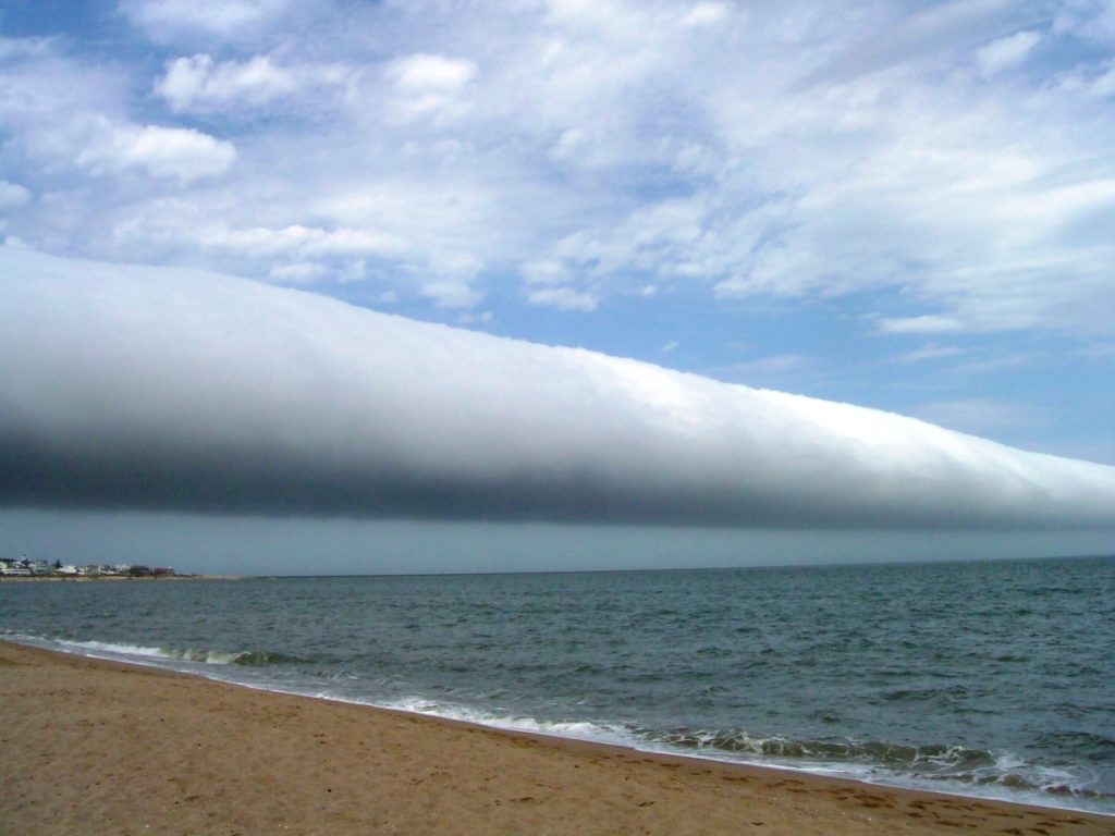
Tag: condensation

  • Collecting Water in the Desert

    Collecting Water in the Desert

    Desert-dwelling plants like cactuses have to be efficient collectors of water. Many types of cactus are particularly good at gathering water from fog that condenses on their spines. Droplets that form near a spine’s tip move slowly but inexorably toward the base of the spine so that the cactus can absorb them. The secret to this clever transport lies in the microstructure of the spine’s surface. The

    Gymnocalycium baldianum cactus, for example, has splayed scales along its spines. Capillary interactions with the scales result in differences in curvature on either side of the droplet. Curved fluid surfaces generate what’s known as Laplace pressure, with a tighter radius of curvature causing a larger Laplace pressure. Because the curvature of the droplet varies from the base side to the tip side of the spine, the difference in Laplace pressures across the droplet creates a force that drives the droplet toward the spine’s base. (Image credit: C. Liu et al., source)

  • Vapor Cones

    Vapor Cones

    Vapor cones typically appear around aircraft flying in the transonic regime–near, but still below, the speed of sound. Air moving over the vehicle accelerates and decelerates as it moves around different parts of the plane; if it didn’t, the plane couldn’t generate lift and wouldn’t fly. When the local flow accelerates past the speed of sound, the accompanying drop in pressure and temperature can be enough to for conditions to fall below the dew point, causing the condensation we see. At the back of the airplane, a shock wave decelerates the airflow back to subsonic speeds and raises local conditions back above the dew point, thereby truncating the cone. (Image credit: C. Caine)

  • Wave Clouds Over the Galapagos

    Wave Clouds Over the Galapagos

    This dramatic example of Kelvin-Helmholtz clouds was taken near the Galapagos Islands last week. The shark-fin-like clouds are the result of two air layers moving past one another. The velocity difference at their interface creates an unstable shear layer that quickly breaks down. The resemblance of the clouds to breaking ocean waves is no coincidence – the wind moving over the ocean’s surface generates waves via the same Kelvin-Helmholtz instability. In the case of the clouds above, the lower layer of air was moist enough to condense, which is why the pattern is visible. Clouds like these don’t tend to last for long because the disturbances that drive the instability grow exponentially quickly, leading to turbulence. (Image credit: C. Miller; via Washington Post; submitted by @jmlinhart)

    ——————

    Help us do some science! I’ve teamed up with researcher Paige Brown Jarreau to create a survey of FYFD readers. By participating, you’ll be helping me improve FYFD and contributing to novel academic research on the readers of science blogs. It should only take 10-15 minutes to complete. You can find the survey here.

  • Featured Video Play Icon

    Cloud Formation

    Clouds are so ubiquitous here on Earth that it’s easy to take them for granted. But there’s remarkable complexity in the mechanics of their formation. This great video from Minute Earth steps through the processes of evaporation and condensation that drive basic cloud formation. After evaporation, buoyancy lifts warm, moist air upward. That warm air expands and cools until it reaches an altitude where water droplets can condense onto dust particles in the atmosphere. These droplets form the wispy cloud we see. Turbulence mixes these droplets and helps them collide and grow. Interestingly, although we understand the basic process of cloud formation, relatively little is understood about the details, and the subject is still very much an area of active research. (Video credit: Minute Earth; via io9)

  • Pyrocumulus Clouds

    Pyrocumulus Clouds

    Pyrocumulus clouds tower tall above a wildfire in these photos taken last week from an Oregon National Guard F-15C. Most cumulus clouds form when the sun-warmed surface heats air, causing it to rise and carry moisture upward where it condenses to form clouds. In pyrocumulus clouds, the driving heat is supplied by a forest fire or volcanic eruption. The hot, rising air carries smoke and soot particles upward, where they become nucleation sites for condensation. Pyrocumulus clouds can be especially turbulent, and the gusting winds they produce can exacerbate wildfires. In some cases, the clouds can even develop into a pyrocumulonimbus thunderstorm with rain and lightning.  (Photo credit: J. Haseltine; via NASA Earth Observatory)

  • Featured Video Play Icon

    Steam Hammer

    The steam hammer phenomenon–and the closely related water hammer one–is a violent behavior that occurs in two-phase flows. Nick Moore has a fantastic step-by-step explanation of the physics, accompanied by high-speed footage, in the video above. Pressure and temperature are driving forces in the effect, beginning with the high-temperature steam that first draws the water up into the bottle. As the steam condenses into the cooler water, the steam’s pressure drops, drawing in more water. Eventually it drops low enough that the incoming water drops below the vapor pressure. This triggers some very sudden thermodynamic changes. The drop in pressure vaporizes incoming water, but the subsequent cloud cools rapidly, which causes it to condense but also drops the pressure further. Water pours in violently, cavitating near the mouth of the bottle because the acceleration there drops the local pressure below the vapor pressure again. The end result is a flow that’s part-water, part-vapor and full of rapid changes in pressure and phase. As you might imagine, the forces generated can destroy whatever container the fluids are in. Be sure to check out Nick’s bonus high-speed footage to appreciate every stage of the phenomenon. (Video credit and submission: N. Moore)

  • Featured Video Play Icon

    Airborne Aerosols

    This numerical simulation from NASA Goddard shows the motion of particulates in Earth’s atmosphere between August 2006 and April 2007. These aerosols come from various sources including smoke, soot, dust, and sea salt. As these fine particles move through atmosphere, they can have significant effects on weather as well as climate. For example, the particles serve as nucleation sites for the condensation and formation of rain drops. (Video credit: NASA Goddard SFC)

  • Vapor Cone

    Vapor Cone

    This stunning National Geographic photo contest winner shows an F-15 banking at an airshow and a array of great fluid dynamics. A vapor cloud has formed over the wings of the plane due to the acceleration of air over the top of the plane. The acceleration has dropped the local pressure enough that the moisture of the air condenses.  Some of this condensation has been caught by the wingtip vortices, highlighting those as well. Finally, the twin exhausts have a wake full of shock diamonds, formed by a series of shock waves and expansion fans that adjust the exhaust’s pressure to match that of the ambient atmosphere. (Photo credit: Darryl Skinner/National Geographic; via In Focus; submitted by jshoer)

  • Helicopter Vortices

    Helicopter Vortices

    When conditions are just right, the low pressure at the center of a wingtip vortex can drop the local temperature below the dew point, causing condensation to form. Here vortices are visible extending from the tips of the propellers in addition to the wingtip. Because of the spinning of the propeller and the forward motion of the airplane, the prop vortices extend backwards in a twisted spiral that will quickly break down into turbulence. The same behavior can be observed with helicopter blades. (Photo credit: benurs)

  • Aircraft Contrails

    [original media no longer available]

    Under the right atmospheric conditions, condensation can form, even at low speeds, as moist air is accelerated over airplane wings. This acceleration causes a local drop in pressure and temperature, which can cause water vapor in the air to condense. The condensation can sometimes get pulled into the wingtip vortices shed off of the wings, tail, and ailerons of an aircraft, as in the video above, making the aerodynamics of the airplane visible to the naked eye.