Photographer Mike Olbinski returns with another incredible storm-chasing timelapse video, this time all in black-and-white. To me, that choice helps “Pulse” emphasize the ominous majesty of these supercells and tornadoes by highlighting the textures that make up the clouds. Watching clouds in timelapse, they seem to materialize from nowhere as moisture drawn up from the land cools and condenses. Sped up, suddenly the convective rotation and the roiling turbulence inside clouds is perfectly clear. I especially love the sequence beginning at 2:25, where a distant black line slowly transforms into an incredible landscape marked with successive waves of rolling, turbulent clouds. Watch this one on a large screen at a high resolution, if you can. You won’t regret it! (Video credit: M. Olbinski)
Tag: meteorology

Roll Cloud Over Chicago
A cold front passing through Chicago last week triggered a roll cloud, shown in the timelapse above. These clouds look like spinning horizontal tubes and form in areas where cool, sinking air displaces warmer, moist air to higher altitudes. The moist air is forced up along the cloud’s leading edge, causing it to cool and condense into cloud. Air on the trailing edge sinks downward again, warming and dissipating the cloud. The clouds are a visible form of soliton, or solitary wave, traveling through the atmosphere. They go by several other names, too, including Morning Glory clouds and arcus clouds. (Image credit: A. King; via Colossal)

Microburst
Earlier this week a Columbus, OH TV station tower camera caught this awesome timelapse footage of several microbursts in a thunderstorm. A microburst is a sudden, localized downdraft inside the storm. You can see a clear microburst starting at about 0:30 seconds. Note how it flares up and out as it hits the ground, eventually settling around the time a rainbow appears on the left edge of the frame. These strong winds moving down then curling out can be dangerous, both to structures on the ground and to any aircraft unfortunate enough to be taking off or landing in the storm. (Video credit: WCMH; submitted by
A. Bcstractor)
Crisscrossing Clouds
This natural-color satellite image shows crisscrossing cloud patterns off coastal Africa. These distinctive lines in the sky are gravity waves, and they form when air masses get displaced upward by terrain or other conditions. In this case, dry air cooled overnight on land before moving out over the ocean. That displaced warm, humid air above the water and forced it upward, where it eventually cooled and condensed into clouds. Gravity created the ripple-like waves; as the moist air cooled, gravity again pulled it downward – leaving behind a clear sky. Once the humid air sank, the dry air pushed it up again, creating another line of clouds and continuing the cycle. (Image credit: NASA; via NASA Earth Observatory)
“Vorticity”
Photographer Mike Olbinski is back with another storm-chasing timelapse entitled “Vorticity”. Like his previous work, this film is a breath-taking example of physics in action. It is well worth taking a few minutes to watch in fullscreen, at high resolution, and with headphones. Olbinski’s timelapses beautifully capture the incredible dynamic motion of our atmosphere. Fittingly, “Vorticity” is all about the swirling, roiling motion of supercell thunderstorms and the tornadoes they can spawn, but the film also captures many other great phenomena from the convection that builds clouds to unusual formations like undulatus asperatus and mammatus clouds. (Video credit: M. Olbinski; submitted by Paul vdB)

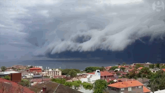
Shelf Cloud
Sydney, Australia was treated to a spectacular meteorological show over the weekend when an impressive shelf cloud swept over the city. These timelapses show the dramatic leading edge of the incoming thunderstorm. Notice how the cloud streams upward along the shelf. The storm is driven by this updraft of warm moist air, which rises until it is capped by the troposphere. At this point, the air spreads, creating an anvil-like shape, and cools. The moisture drawn up at the storm’s front will condense, freeze, and fall as rain or hail. When the updraft weakens, the storm will be dominated by the downdraft of the falling precipitation and eventually peter out. (Image credit: W. Reed and H. Vann, source; via J. Hertzberg)

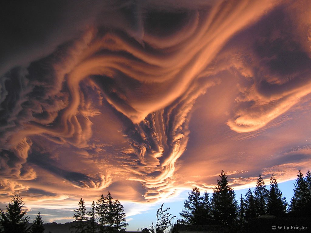
A New Cloud
These unusual and spectacular clouds are known as undulatus asperatus. Though they have been proposed as a new type of cloud, they are as yet officially unrecognized. Despite their dramatic appearance, these clouds are not associated with storms. Instead, they’re thought to form in a process similar to mammatus clouds, where wind shear at the cloud level causes undulations to form. This wave-like structure is especially visible in the photo above thanks to a low sun angle illuminating the underside of the clouds. (Image credit: W. Priester; via APOD)
“Monsoon II”
Every child learns about the water cycle in school, but an academic description of the process often lacks nature’s grandeur. In “Monsoon II” photographer Mike Olbinski captures the majesty of cloud formation and rainfall in a way that rekindles awe for the scale of the process. It begins with bright clouds popping up, the result of warm moist air rising from the ground and cooling at altitude. As more water vapor evaporates, rises, and condenses, water droplets collide in these clouds, coalescing and growing until they grow too large and heavy to stay aloft. These are the droplets that fall in sheets of rain, blurring the air beneath them. There’s an incredible beauty to watching rain fall from a distance; it looks calm and localized in a way that’s utterly at odds with the experience from inside the storm. (Video credit: M. Olbinski; submitted by jshoer)

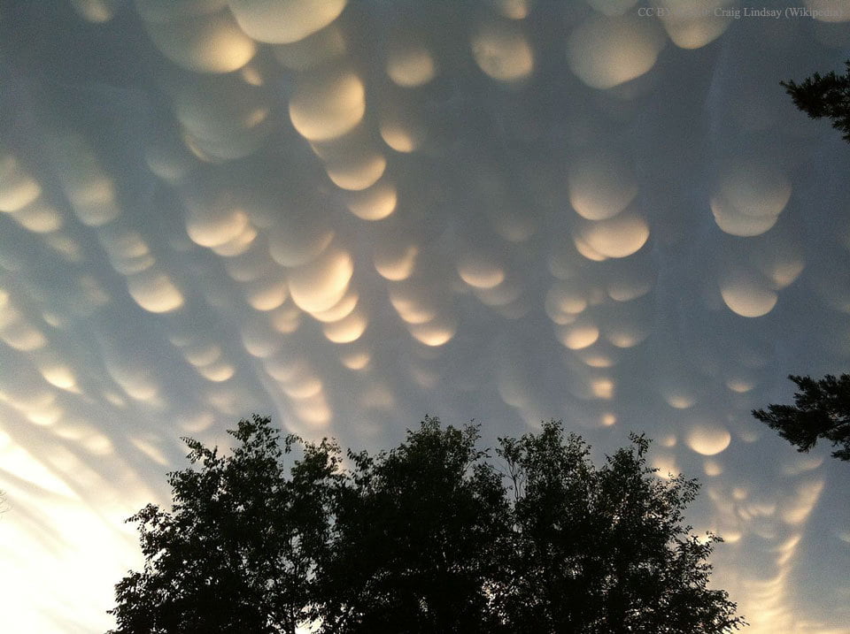
Mammatus Clouds
Mammatus clouds, the bubble-shaped protrusions sometimes seen underneath cumulus clouds, are a rare and dramatic type of cloud. The mammatus is typically short-lived, with lobes lasting only 10 minutes or so. Their rarity and short appearances are among the reasons why this cloud type has been little studied. As a result, there are many theories as to how the clouds form their distinctive, bulbous lobes, but, to my knowledge, there is no single widely accepted explanation. Mammatus often appear before or after severe thunderstorms and are associated with strong turbulence, so this may play a factor in their formation. (Photo credit: C. Lindsey; via APOD)
“The Chase”
Sometimes it takes timelapse photography to truly appreciate the dynamic behavior of our atmosphere. In “The Chase” Mike Olbinski, whose work we’ve featured previously, has captured some of the most incredible and stunning weather timelapse footage I have ever seen. Despite watching it repeatedly, I continue to be awed to the point that I have no words. Seriously, just watch it. Be amazed by the drama of our sky. (Video credit: M. Olbinski)