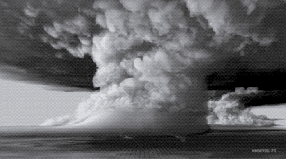
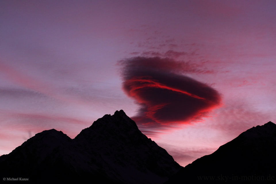
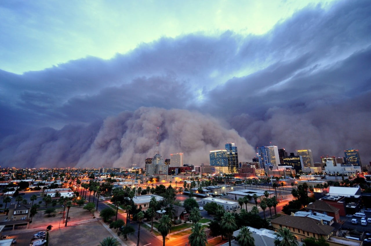
Tag: meteorology

  • Featured Video Play Icon

    “Fractal”

    Timelapses are a wonderful way to capture the power and majesty of storms like the supercell thunderstorms featured in Chad Cowan’s “Fractal”. The video contains snapshots from six years’ worth of storms over the US’s Great Plains. The highlights include some spectacular mammatus clouds (0:30) and excellent billowing cloud formation (1:27) with turbulence every bit as towering as that of a volcanic plume. June is one of the best months for amazing storms in the Great Plains, largely thanks to the atmospheric mixing that occurs over the Rocky Mountains. If you have the opportunity to witness these amazing natural displays, enjoy it, but be safe! (Video credit: C. Cowan; image via Colossal)

  • Tendrils of Fog

    Tendrils of Fog

    Fog snakes its way from the ocean into the Strait of Juan de Fuca in this animation constructed from satellite imagery. The strait lies between Vancouver Island and the Olympic Peninsula in the Pacific Northwest. Fogs like this form when skies are clearer and heat from the surface is able to escape upward. The surface air then cools and condenses into fog. Steady winds pushed fog into the strait over the course of about 9 hours. There’s a remarkable level of detail in the satellite images, taken by the new GOES-16 satellite that launched in late 2016. Notice the ragged wave front as the fog stretches eastward and the shock-wave-like lines behind it in the strait. Both result from interactions between the fog cloud and the shape of the land masses it’s encountered. (Image credit: NASA Earth Observatory)

  • Featured Video Play Icon

    Asperitas Sunset

    Asperitas clouds, previously known as undulatus asperatus, are the most recently recognized cloud type. These clouds make the sky look like the ocean rolling in waves. Photographer Mike Olbinski, on a recent storm chase earlier this month, caught these spectacular asperitas clouds near sunset. The clouds’ effect is unusual under normal circumstances and completely surreal with this lighting. Check out the video for the full effect. Olbinski caught the clouds on the outskirts of a dying storm cell. That’s a common place to see these formations; despite their ominous appearance, they do not develop storms and are more often seen as storms are ending. (Video and image credit: M. Olbinski; h/t to Paul vdB)

  • Featured Video Play Icon

    Sky Glow

    This short but spectacular timelapse video shows the Grand Canyon filled with fog. This phenomenon, known as a temperature inversion, occurs when a warm layer of air traps cold, moist air near the ground. As the inversion develops in the video, you can see wisps of clouds popping up in the canyon, seemingly out of nowhere, as moisture evaporated from the surface condenses in the cool air. Once fog fills the canyon, it flows and laps against the canyon’s sides, much like waves on the ocean. In fact, the physics here is quite similar, just at a much slower speed. (Video and image credit: H. Mehmedinovic / SKYGLOWPROJECT; via Gizmodo; submitted by Ian S.)

  • Simulating Thunderstorms

    Simulating Thunderstorms

    With today’s supercomputing power, it’s possible to simulate entire thunderstorms to study how and why some of them can spawn deadly tornadoes. The animation above comes from a computer simulation of a supercell thunderstorm. The simulation uses initial conditions from a 2011 storm that produced an EF-5 tornado – the highest category of tornado, based on its wind speeds. To see more of the simulation, check out the video below. One thing that might surprise you is just how enormous the towering supercell clouds are compared to the tornado produced in the simulation. Often what we can see of a storm from the ground is only the tiniest part of what goes into producing it. (Image credit: L. Orf et al., source; GIF via @popsci; video credit: UWSSEC)

  • Featured Video Play Icon

    Asperitas Clouds

    This short timelapse captures an impressive display of asperitas clouds over Augusta, Georgia. Asperitas clouds, previously known as undulatus asperatus, are a new classification recommended by the Cloud Appreciation Society in 2009. Recently, the World Meteorological Organization indicated they would include the clouds in the their latest Cloud Atlas under the new name. Asperitas clouds form under conditions similar to those of mammatus clouds – in areas with stable, cool, sinking air near the outskirts of thunderstorms. Despite their ominous appearance, the clouds are not themselves an indicator of severe weather – just a spectacular display of our atmospheric dynamics. Happy World Meteorological Day! (Video credit: A. Walters; via Rebekah W/Flow Viz)

  • Happy Valentine’s Day

    Happy Valentine’s Day

    This heart-shaped atmospheric apparition is a lenticular cloud captured over the mountains of New Zealand. As you can see in the companion video, the cloud itself remains stationary over the mountain. This is a key feature of lenticular clouds, which form when air flowing over/around an obstacle drops below the dew point. This causes moisture in the air to condense for a time before it descends and warms once more. Thus, even though air is continuously flowing past, what we see is a stationary, lens-shaped cloud. Happy Valentine’s Day from FYFD!  (Image credit: M. Kunze, video; via APOD)

  • As the Dust Blows In

    As the Dust Blows In

    This towering cloud of dust is known as a haboob, and while it appears apocalyptic, it is a relatively common occurrence in parts of the world, including the U.S. southwest and the Middle East. Haboobs often form when a collapsing thunderstorm releases a downburst of cold air. That wind picks up loose dust along the ground and creates a wall of sediment that may be as much as 100 kilometers wide and several kilometers tall. Inside the haboob, winds can reach speeds as high as 100 kph and visibility can be reduced to nearly zero. Because of this, the storms can be quite dangerous, especially to anyone who attempts to drive during one. (Image credit: D. Bryant)

  • Weather Posters

    Weather Posters

    Weather Underground has created a whole series of posters celebrating and briefly explaining various weather phenomena. Many of their subjects are beautiful and unusual types of clouds like the lenticular clouds that form over mountains and hole-punch clouds created when supercooled water vapor gets disturbed. They have a few non-cloud phenomena we’ve discussed previously, too, such as dust devils and bizarre, wind-formed snow rollers. I highly encourage you to check out the full collection, which they’ve made available as phone and computer wallpapers as well as posters. Personally, these combine two of my favorite things: fluid dynamics and retro-style nature posters! (Image credit: Weather Underground)

  • Featured Video Play Icon

    “Pulse”

    Photographer Mike Olbinski returns with another incredible storm-chasing timelapse video, this time all in black-and-white. To me, that choice helps “Pulse” emphasize the ominous majesty of these supercells and tornadoes by highlighting the textures that make up the clouds. Watching clouds in timelapse, they seem to materialize from nowhere as moisture drawn up from the land cools and condenses. Sped up, suddenly the convective rotation and the roiling turbulence inside clouds is perfectly clear. I especially love the sequence beginning at 2:25, where a distant black line slowly transforms into an incredible landscape marked with successive waves of rolling, turbulent clouds. Watch this one on a large screen at a high resolution, if you can. You won’t regret it! (Video credit: M. Olbinski)