The Cranston wildfire in California is intense enough that it’s creating its own weather. This timelapse video shows the formation and growth of a pyrocumulus cloud, also associated with volcanoes, over the wildfire. In both instances, the extreme heat causes a massive column of hot, turbulent air to rise. Because ash and smoke are carried upward as well, there are many places for any moisture in the atmosphere to nucleate, forming the cloud we see. In timelapse, the roiling nature of the air’s motion is especially apparent. This turbulence can be dangerous, as it may contribute to high winds and even lightning, both of which can spread the fire further. (Video credit: J. Morris; via James H.)
Tag: meteorology

Mimicking Hurricanes


Hurricanes are a frequent and potentially deadly occurrence for many parts of the world. Although forecasting models have improved, there is still a lot about the physics of these storms that we don’t fully understand, in part because getting direct measurements from the real thing is so difficult and hazardous. Researchers at the University of Miami have instead built their own hurricane generator, capable of sustained 200 mph winds – strong enough to create Category 5 hurricane conditions. In this facility, they can study details of the storm up close, allowing them to distinguish effects from the scale of large waves down to the physics of the sea spray. Learn more and see the facility in action in the Science Friday video below. (Video credit: L. Groskin/Science Friday; image credits: L. Groskin/Science Friday, University of Miami, SUSTAIN Lab; submitted by Guillaume D.)

Snowmelt
Much of the rain that falls on Earth began as snow high in the atmosphere. As it falls through warmer layers of air, the snowflakes melt and form water droplets. The details of this melting process have been difficult to capture experimentally, but a new computational model may provide insight. The basic process has a couple stages. As snow begins to melt, surface tension draws the water into concave areas nearby. When those regions fill up, the water flows out and merges with neighboring liquid, forming water droplets around a melting ice core.
Although this same sequence was observed for many types of snow, scientists also observed some important differences between rimed and unrimed snowflakes. Rime forms when supercooled water droplets freeze onto the surface of a snowflake. Lightly rimed snow still looks light and fluffy, like the animation above, but heavily rimed snow forms denser and more spherical chunks. Because there are lots of porous gaps in heavily rimed snow, water tends to gather there during initial melting. Rimed snow was also more likely to form one large water droplet rather than breaking into multiple droplets like snow with less rime. For more, check out NASA’s video and the Bad Astronomy write-up. (Image credit: NASA, source; research credit: J. Leinonen and A. von Lerber; via Bad Astronomy; submitted by Kam Yung-Soh)

Castle-like Clouds
An astronaut captured this towering cloud over Andros Island from orbit aboard the ISS. This is a cumulus castellanus cloud, named for the castle-like crenelations at its top. Castellanus clouds form in areas with strong vertical updrafts, often due to cloud-level atmospheric instabilities rather than heating at the Earth’s surface. These clouds frequently proceed rain or even thunderstorms. What distinguishes castellanus from other types of cumulonimbus clouds is their shape: castellanus clouds have protrusions that are taller than they are wide – like the castles for which they are named. (Image credit: NASA / Expedition 48; via NASA Earth Observatory)
“Breathe”


In black and white, the towering power of a thunderstorm looks almost apocalyptic. Photographer Mike Olbinski’s latest storm timelapse, “Breathe,” features roiling turbulence, distant downpours, and eerie mammatus clouds. Supercell thunderstorms churn and rotate over empty horizons. Billowing cumulus clouds condense from bright skies. Flashes of lightning reveal the outlines of massive thunderheads. It’s a beautiful glimpse of atmospheric fluid dynamics in action, with every texture magnified and enhanced by the stark black and white palette. (Video and image credit: M. Olbinski; via Gizmodo)

Lincolnshire KH Clouds


These beautiful Kelvin-Helmholtz clouds were spotted over Lincolnshire on December 19th. They form between two layers of air, one of which is moving faster than the other. Although that situation is not very unusual, the conditions have to be just right for visible clouds to form at that interface between layers, and the clouds themselves are typically short-lived. This set is particularly lovely with its smooth curves and breaking wave form. If you, like me, love these clouds but never manage to see them yourself, you can always try wearing some instead! (Image credit: A. Towriss; via BBC News; submitted by Vince D.)
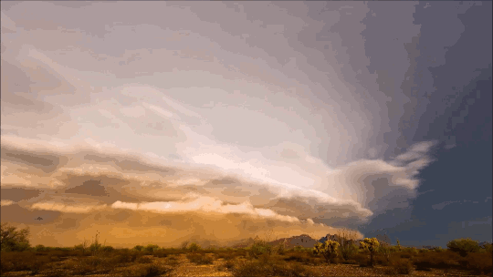
“Monsoon IV”
It’s a cliché to claim that the sky is bigger in the American West, but the wide, open views in that region do offer a very different perspective on weather. Photographer Mike Olbinski’s works give viewers a taste of that perspective of far-off thunderstorms, towering anvil clouds, and massive downpours in the distance. At the same time, many of his sequences illustrate the birth and death of these massive storms. As warm, moist air rises, a puffy cumulus cloud (below) swells upward as fresh moisture condenses. When it reaches a thermal cap and can rise no further, precipitation begins to fall, dragging surrounding air with it. This is the mature stage of a storm, when both updrafts and downdrafts exist simultaneously.
Eventually, the storm’s power begins to wane as the downdrafts cut off the updrafts that feed the storm. Sometimes this occurs in a massive downdraft where cool air sinks straight down and, upon encountering the ground, spreads radially outward. In dry regions, this outward burst of ground-level winds can pick up dirt, dust, and sand, forming a wall-like haboob (below) that advances past the remains of the storm. Watch the entire video to see some examples in their full glory! (Video and image credit: M. Olbinski, source; via Rex W.)


Creating Clouds
Despite their ubiquity and importance, we know surprisingly little about how clouds form. The broad strokes of the process are known, but the details remain somewhat fuzzy. One challenge is understanding how nucleation – the formation of droplets that become clouds or rain – works. A recent laboratory experiment in an analog cloud chamber suggests that falling rain drops may help spawn more rain drops.
The experiment takes place in a chamber filled with sulfur hexafluoride and helium. The former acts like water in our atmosphere, appearing in both liquid and vapor forms, while the latter takes the place of dry components of our atmosphere, like nitrogen. The bottom of the chamber is heated, forming a liquid layer of sulfur hexafluoride, seen at the bottom of the animation above. The top of the chamber is cooled, encouraging sulfur hexafluoride vapor to condense and form droplets that fall like rain. A top view of the same apparatus during a different experiment is shown in this previous post.
When droplets fall through the chamber, their wakes mix cold vapor from near the drop with warmer, ambient vapor. This changes the temperature and saturation conditions nearby and kicks off the formation of microdroplets. These are the cloud of tiny black dots seen above. Under the right conditions, these microdroplets grow swiftly as more vapor condenses onto them. In time, they grow heavy enough to fall as rain drops of their own. (Image credits: P. Prabhakaran et al.; via APS Physics; submitted by Kam-Yung Soh)

Soaring Pelicans


Earlier this summer, I looked up on a bright, sunny day and saw a quartet of black and white figures soaring overhead. Initially, I thought it might be a formation of kites or unmanned aerial vehicles (UAVs) because I saw no flapping as the group wheeled about. With the help of the Cornell Lab of Ornithology’s awesome Merlin app, I was able to identify the soarers as American white pelicans – not a species I’d expected to find flying along the Front Range of the Rocky Mountains! (Turns out, they breed on lakes around here.)
The reason I saw so little flapping is that the birds were riding thermals. As the sun heats the ground, air near the surface warms up and begins to rise due to its buoyancy. Pelicans interested in flying between breeding and foraging grounds will start testing the thermals early in the day, as soon as they begin to form. As the heating continues, the intensity of thermals strengthens and they extend higher into the atmosphere. This is where the birds can really excel at using atmospheric energy for their flight. Pelicans will circle within a thermal until they reach roughly the middle of its height. Then they will glide, gradually losing altitude until they reach another thermal where they can climb without expending their own energy. With a 2.7 meter wingspan and a relatively low drag coefficient, the pelicans can glide and soar remarkably well. Researchers have even suggested using them as a sort of biological UAV for studying atmospheric dynamics! (Image credits: D. Henise, M. Stratmoen; research credit: H. Shannon et al., pdfs – 1, 2)

Review: “ABCs From Space”


For me, one of the most fun aspects of studying science is seeking out examples of it in the world around us. Adam Voiland – who writes for NASA Earth Observatory, one of FYFD’s favorite sources for excellent fluids in action – takes this a step further with his children’s book “ABCs From Space: A Discovered Alphabet”. Voiland has sought out satellite imagery from around the world to illustrate all twenty-six letters, creating a lovely book for budding scientists of all sorts.
Each letter has its own full-page image with no added text, like the G and H shown above. Younger children will have fun identifying and tracing out each letter. The back of the book provides more detail for older kids and adults, including brief descriptions of where and what each image shows, a map of all image locations, and some FAQs about satellite imagery and the geology, meteorology, and earth science on display. There are enough specifics to satisfy casual interest, but I suspect that science-inclined adults will find the book a fun springboard for more in-depth discussions with curious kids.
Fluid dynamics itself makes a solid showing in the book. Several letters are formed by vortices (like G above) and various types of clouds, including the ship track clouds (like H) that form when water condenses on aerosols released by ship exhaust. There are also meandering rivers, creeping glaciers, and erosion features among the letters.
I’m often asked about resources for teaching kids about fluid dynamics, and Voiland’s book is a great option for introducing that subject, as well as many other fields of science. (Image credits: A. Voiland/Simon & Schuster)
Disclosure: I received a review copy of this book but was not otherwise compensated by the author or publisher. All opinions are my own. Additionally, this post contains affiliate links. Purchases made using these links do not cost you anything extra but may provide FYFD with a commission. Thanks!