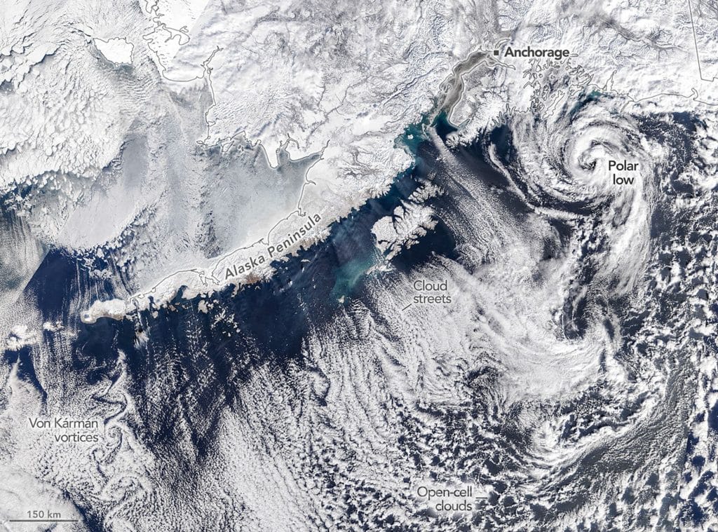
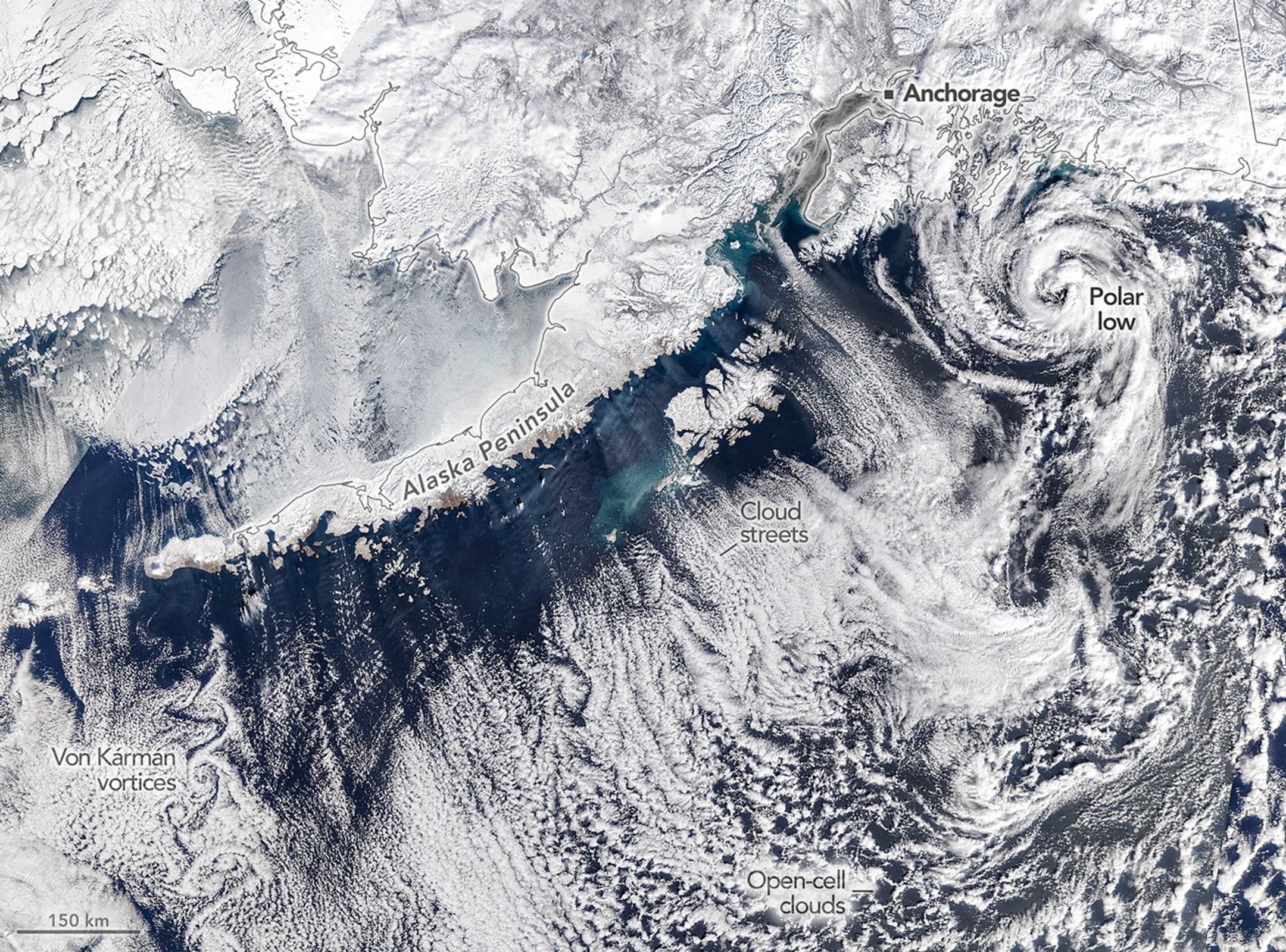
Tag: cloud formation

  • Cloudy Mornings and Clear Evenings

    Cloudy Mornings and Clear Evenings

    In the past few decades, our knowledge of exoplanets has exploded, but we’re still relatively limited in what we can learn about these worlds. That’s due, in large part, to the indirect way we observe them. Most exoplanets are found when we see them transit, passing between Earth and their star. During a transit, the planet blocks a portion of the light we would otherwise detect from the star, letting us know that something’s there. We’re often able to measure the spectra of light passing through the exoplanet’s atmosphere, giving us a glimpse of chemical signatures.

    Today’s study looks at exoplanet WASP-94A b, a gas giant tidally-locked so that only one side ever faces its star. In its transit, researchers could clearly measure different spectra from the morning and evening sides of the planet. The asymmetry seems to indicate that the exoplanet develops thick clouds on the nightside, which then dissipate during the daytime. (Image credit: H. Robbins/JHU; research credit: S. Mukherjee et al.; via Nature)

    Artist's conception of an exoplanet with clouds forming on the nightside and dissipating on the dayside.
    Fediverse Reactions
  • “Opening the Vortex”

    “Opening the Vortex”

    Photographer Lisa K. Kuhn captured a spectacular lenticular cloud over Mount Shasta in this image from the Sony World Photography Awards. These lens-shaped clouds occur most often near mountains and other terrain that forces air to flow up and over it. As the air cools, water condenses out, forming the cloud. When the air flows down and warms, condensation is no longer possible. The end result is a cloud that appears stationary against the mountain, even though air is continuously moving past. Add in the long sun angles and beautiful colors of near-sunset and the results are incredible. (Image credit: L. Kuhn; via Colossal)

    A spectacular lenticular cloud over Mount Shasta near sunset. Photo by Lisa K. Kuhn.
  • Dusty Clouds Make More Ice

    Dusty Clouds Make More Ice

    Even when colder than its freezing point, water droplets have trouble freezing–unless there’s an impurity like dust that they can cling to. It’s been long understood in the lab that adding dust allows water to freeze at warmer temperatures, but proving that at atmospheric scales has been harder. But a new analysis of decades’ worth of satellite imagery has done just that. The team showed that a tenfold increase in dust doubled the likelihood of cloud tops freezing.

    Since ice-topped clouds reflect sunlight and trap heat differently than water-topped ones, this connection between dust and icy clouds has important climate implications. (Image and research credit: D. Villanueva et al.; via Eos)

    Fediverse Reactions
  • Featured Video Play Icon

    “Vorticity 6”

    It’s time for another storm-chasing timelapse from photographer Mike Olbinski! “Vorticity 6” focuses on supercell thunderstorms and their tornadoes. There’s billowing turbulent convection, undulating asperitas, bulging mammatus, microbursts, and more. There’s nothing like timelapse to highlight the growth, rotation, and shear involved in these storms. (Video and image credit: M. Olbinski)

    Fediverse Reactions
  • Seeding Clouds With Wildfire

    Seeding Clouds With Wildfire

    Raging wildfires send plumes of smoke up into the atmosphere; that smoke is made up of tiny particles that can serve as seeds — nucleation sites — where water vapor can freeze and form clouds. To understand wildfire’s effect on cloud growth, researchers sampled air from the troposphere (the atmosphere’s lowest layer) both in and around wildfire smoke.

    The team found that smoke increased the number of nucleating particles up to 100 times higher than the background air, but the exact make-up of the smoke varied significantly by fire. Smoke particles were mostly organic, though inorganic ones appeared as well. The temperature of a fire, as well as what materials it was burning, made a big difference; the fire where they measured the highest particle concentrations included lots of unburned plant material, thought to be carried aloft by turbulence around the fire. (Image credit: K. Barry; research credit: K. Barry et al.; via Eos)

    Fediverse Reactions
  • Penguin Poo Seeds Antarctic Clouds

    Penguin Poo Seeds Antarctic Clouds

    Forming clouds requires more than just water vapor; every droplet in a cloud forms around a tiny aerosol particle that serves as a seed that vapor can condense onto. Without these aerosols, there are no clouds. In most regions of the world, aerosols are plentiful — produced by vegetation, dust, sea salt, and other sources. But in the Antarctic, aerosol sources are few. But a new study shows that penguins help create aerosols with their feces.

    Penguin feces is ammonia-rich, and that ammonia, when combined with sulfur compounds from marine phytoplankton, triggers chemistry that releases new aerosol particles. The researchers measured ammonia carried on the wind from nearby penguin colonies and found that the birds are a large ammonia source, producing 100 to 1000 times the region’s baseline ammonia levels. In combination with another ingredient in penguin guano, the researchers found the penguins boosted aerosol production 10,000-fold. That means penguins can actually influence their environment, helping to create clouds that keep Antarctica cooler. (Image credit: H. Neufeld; research credit: M. Boyer et al.; via Eos)

    Fediverse Reactions
  • Featured Video Play Icon

    “Monsoon 7”

    Storm-chasing photographer Mike Olbinski (previously) returns with another stunning timelapse of summer thunderstorms in the western U.S. I never tire of watching the turbulent convection, microbursts, billowing haboobs, and undulating clouds Olbinski captures. His work is always a reminder of the incredible power and energy contained in our atmosphere and unleashed in cycles of warming and cooling, evaporation and condensation. (Video and image credit: M. Olbinski)

  • Wave Clouds in the Atacama

    Wave Clouds in the Atacama

    Striped clouds appear to converge over a mountaintop in this photo, but that’s an illusion. In reality, these clouds are parallel and periodic; it’s only the camera’s wide-angle lens that makes them appear to converge.

    Wave clouds like these form when air gets pushed up and over topography, triggering an up-and-down oscillation (known as an internal wave) in the atmosphere. At the peak of the wave, cool moist air condenses water vapor into droplets that form clouds. As the air bobs back down and warms, the clouds evaporate, leaving behind a series of stripes. You can learn more about the physics behind these clouds here and here. (Image credit: Y. Beletsky; via APOD)

    Fediverse Reactions
  • Lenticular Landscape

    Lenticular Landscape

    Mountain ridgelines push oncoming winds up and over their peaks, creating the conditions for some spectacular condensation. If the displaced air is moist enough, it cools and condenses into a cloud that appears to hover over the peak. In reality, winds are constantly moving up and over the mountain, condensing into visible cloud where the temperature is cool enough and then morphing back to water vapor once temperatures increase. This process can create stacked lenticular clouds like those seen here. This spot in New Zealand sees lenticular clouds so often that the formation has its own name: Taieri Pet! (Image credit: satellite image – L. Dauphin, b/w – National Library; via NASA Earth Observatory)

    Black-and-white photo of an instance of the Taieri Pet lenticular cloud structure.
    Black-and-white photo of an instance of the Taieri Pet lenticular cloud structure.
  • When Fires Make Rain

    When Fires Make Rain

    The intense heat from wildfires fuels updrafts, lifting smoke and vapor into the atmosphere. As the plume rises, water vapor cools and condenses around particles (including ash particles) to form cloud droplets. Eventually, that creates the billowing clouds we see atop the smoke. These pyrocumulus clouds, like this one over California’s Line fire in early September 2024, can develop further into full thunderstorms, known in this case as pyrocumulonimbus. The storm from this cloud included rain, strong winds, lightning, and hail. Unfortunately, storms like these can generate thousands of lightning strikes, feeding into the wildfire rather than countering it. (Image credit: L. Dauphin; via NASA Earth Observatory)