
Although they may look sinister, roll clouds like this one are no tornado. These unusual clouds form near advancing cold fronts when downdrafts cause warm, moist air to rise, cool below the dew point, and condense into a cloud. Air in the cloud can circulate around its long horizontal axis, but the clouds won’t transform into a tornado. Roll clouds are also known as Morning Glory clouds because they often form early in the day along the Queensland coast, where springtime breezes off the water promote their growth. The clouds do form elsewhere, though; this example is from Wisconsin in 2007. (Image credit: M. Hanrahan; via APOD)
Tag: roll cloud

Weather Posters


Weather Underground has created a whole series of posters celebrating and briefly explaining various weather phenomena. Many of their subjects are beautiful and unusual types of clouds like the lenticular clouds that form over mountains and hole-punch clouds created when supercooled water vapor gets disturbed. They have a few non-cloud phenomena we’ve discussed previously, too, such as dust devils and bizarre, wind-formed snow rollers. I highly encourage you to check out the full collection, which they’ve made available as phone and computer wallpapers as well as posters. Personally, these combine two of my favorite things: fluid dynamics and retro-style nature posters! (Image credit: Weather Underground)

Roll Cloud Over Chicago
A cold front passing through Chicago last week triggered a roll cloud, shown in the timelapse above. These clouds look like spinning horizontal tubes and form in areas where cool, sinking air displaces warmer, moist air to higher altitudes. The moist air is forced up along the cloud’s leading edge, causing it to cool and condense into cloud. Air on the trailing edge sinks downward again, warming and dissipating the cloud. The clouds are a visible form of soliton, or solitary wave, traveling through the atmosphere. They go by several other names, too, including Morning Glory clouds and arcus clouds. (Image credit: A. King; via Colossal)

Roll Clouds

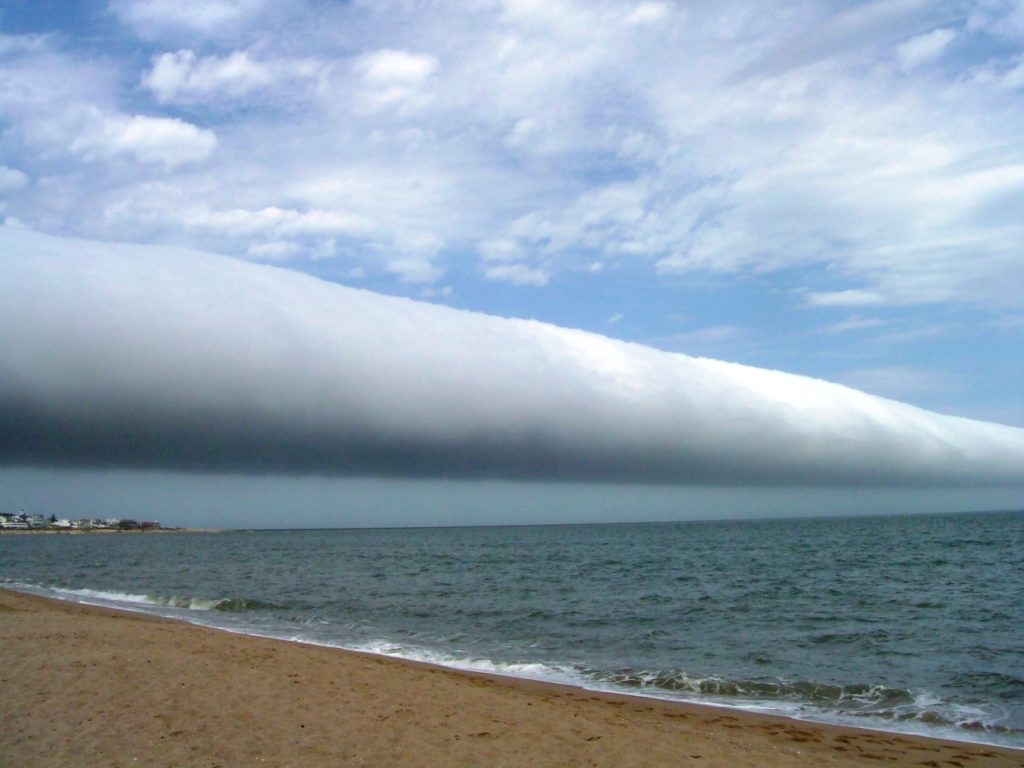
The roll cloud, or Morning Glory cloud, is a rare phenomenon that looks rather like a horizontal tornado. In reality, it is part of a soliton wave traveling through the atmosphere. At its leading edge, moist air is forced upward, causing water vapor to condense, and, at the trailing edge, air moves downward, dissipating the cloud. These clouds are most frequently observed in Australia near the Gulf of Carpentaria, where local geography and sea breezes promote their growth during springtime. The clouds do appear elsewhere on occasion; the photos above show rolls clouds in Calgary, Alberta and coastal Uruguay, respectively. (Image credits: G. E. Nyland, D. M. Eberl; see also: Z. Ouazzani)

The Glory of a Roll Cloud
Roll clouds stretch like a long horizontal tube, spinning as they process across the sky. This class of arcus cloud is relatively rare but occasionally forms in areas where cool air is sinking, along the downdraft of an oncoming storm or in coastal regions as a result of sea breezes. The cooler, sinking air displaces warmer, moist air to higher altitudes where the moisture condenses into a cloud. Winds then roll the cloud parallel to the horizon. Roll clouds are a form of soliton, a solitary wave with a single crest that moves without changing its shape or velocity; this is why the cloud appears so regular as it moves across the sky. These clouds are sometimes also called Morning Glory clouds and form regularly off the coast of Queensland, Australia around October. (Video credit: T. and B. Mask)
A reminder, for those attending the APS DFD conference this weekend: my FYFD talk will be Sunday evening at 5:37pm in Rm 306/307. I will be discussing, among other things, the results of July’s reader survey and science communication.


