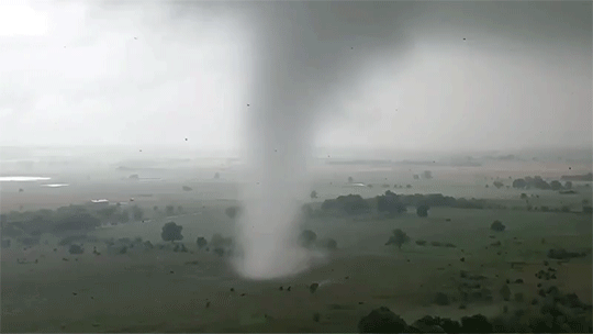
Tag: meteorology

  • Featured Video Play Icon

    The Polar Vortex

    Every year or two, the Northern Hemisphere gets treated to a bout of intensely cold temperatures thanks to the polar vortex. What you may not realize, though, is that it’s not the polar vortex that causes this cold weather – it’s the vortex breaking down. As Simon Clark explains in this video, the polar vortices (one at each pole) are intense and powerful regions of circulation in the stratosphere, or mid-atmosphere. They’re largely responsible for keeping cold air trapped in the Arctic and Antarctic. But occasionally, this region of the atmosphere will suddenly get warmer – to the tune of increasing by 80 degrees Celsius in less than a week! When this happens, a polar vortex will deform and potentially even split into smaller vortices, as seen below. When this happens, the vortex loses its hold on the cold air near the surface, allowing Arctic air to sneak as far south as Texas. After a couple of weeks of affecting our weather, the polar vortex will typically reform and we’ll return to normal. In the meantime, stay warm! (Video and image credit: S. Clark; submitted by Nikhilesh T.)

  • Featured Video Play Icon

    “Haboob”

    Mike Olbinski’s latest storm chasing timelapse, “Monsoon V,” is once again spectacular. Although I do think the name could have been “Haboob” instead, given how many sweeping dust clouds encroach on the viewer. These towering wall clouds of dust can form from downdrafts at the leading edge of a cold front, or from the fading remains of a thunderstorm. In dry, dusty regions like Arizona, the strong downward winds spread outward as they near the ground, picking up dust and sand. Below you can see two examples of haboobs racing ahead of fronts. 

    The middle image shows a microburst, where a sudden, localized downdraft falls out of the storm. Notice how the wind and rain sweep outward as they near the ground. This is typical of any flow heading straight toward a wall! Check out the full video for lots more gorgeous fluid dynamics in action. (Video and image credit: M. Olbinski)

  • The Great Smog of London

    The Great Smog of London

    Our atmosphere is active and ever-changing – except when it isn’t. Some areas, including many cities, are prone to what’s known as a temperature inversion, where a layer of cooler air gets trapped underneath a warmer one. Because this means that a dense layer is caught under a less dense one, the situation is stable and – absent other changes in circumstances – will stick around. There are several ways this can happen, including overnight when areas near the ground cool faster than the atmosphere higher up.

    When temperature inversions persist, they can trap pollutants and create health hazards. One of the worst of these recorded occurred in December 1952 in London. An anticyclone created a temperature inversion over the city that trapped smoke from coal burned to warm homes and reduced visibility – sometimes even indoors – to only a meter or two. Thousands of people died from the respiratory effects of the five-day smog, and it prompted major efforts to improve emissions and air quality. Temperature inversions cannot be avoided, but the Great Smog of London taught us the necessity of reducing their danger.  (Image credit: Getty Images)

  • Featured Video Play Icon

    Rivers in the Sky

    The water cycle is quite a bit more complicated than what we learn in elementary school, and the environment around us contributes to that cycle in invisible but vital ways. In this video, Joe Hanson of It’s Okay to Be Smart pulls back the veil on this in the context of the Amazon river basin and how the Amazon rainforest itself creates an atmospheric river that carries more water than its namesake river.

    Trees release water into the air almost constantly as they transpire. And to trigger that water to fall as rain, trees can release other compounds that serve as a nucleus around which raindrops can form. The condensing raindrops form clouds, which lower the air pressure and create winds, thereby creating an atmospheric river flowing from the Atlantic back up the Amazon River. That stream carries rain that feeds the rainforest and the Amazon River, continuing the cycle. (Video and image credit: It’s Okay to Be Smart)

  • Turbulent Skies

    Turbulent Skies

    The atmosphere above us is a thin layer enclosing our planet, but it roils with activity and energy. Photographer Camille Seamon captures the grandeur of our turbulent skies in her storm shots. These dramatic atmospheric vistas – including mammatus clouds (top), swirling supercells (middle), and turbulent storm clouds (bottom) – are all driven by the flow of heat and moisture. (Image credit: C. Seaman; via Colossal)

  • Growing Droplets

    Growing Droplets

    The moisture in clouds eventually condenses into droplets that grow into raindrops and fall. Some steps in this process are well understood, but others are not. In particular, scientists have struggled with the problem of how droplets grow from about 30 microns to 80 microns, where they’re big enough to start falling and merging.

    Laboratory experiments and numerical simulations (below) have shown that turbulence can help drive small water drops together. When droplets are tiny and light, they simply follow the air flow. But when they’re a little heavier, turbulent eddies (seen in orange below) act like miniature centrifuges, flinging larger water droplets (shown in cyan below) out into clusters, where they’re more likely to collide with one another.

    Although this effect has been seen in experiments and simulation, it’s been difficult to capture in clouds themselves. But a new set of test flights (above) confirms that this mechanism is present in the wild as well! (Image credit: UCAR/NCAR Earth Observing Laboratory, P. Ireland et al., source; research credits: M. Larsen et al., P. Ireland et al.; via APS Physics; submitted by Kam-Yung Soh)

    image
  • Nacreous Clouds

    Nacreous Clouds

    During winter, the polar skies can ignite with mother-of-pearl-like iridescence. Polar stratospheric clouds – also known as nacreous clouds – are a rare, beautiful, and destructive type of cloud found only in high latitudes at altitudes of 15 – 25 km. They are formed from tiny crystals of ice and nitric acid, and they shine brightest a few hours before sunrise or after sunset, when sunlight shines on them but not the surface. Their destructive side is connected with ozone depletion; they serve as reaction sites for chlorofluorocarbons in the atmosphere to react and produce ozone-destroying molecules. The clouds may have cultural significance as well; at least one study suggests they were part of Munch’s inspiration for “The Scream”. (Image credit: A. Light; via Gizmodo)

  • Featured Video Play Icon

    Inside Hurricane Maria

    In addition to looking outward, NASA constantly monitors our own planet using a suite of satellites. In this video, they visualize data taken by the Global Precipitation Measurement Core Observatory of Hurricane Maria two days before it hit Puerto Rico. Instruments on board the satellite measure both liquid and frozen precipitation, giving scientists – and now the public – a glimpse into the heart of a developing hurricane. Be sure to take a look around; it’s a 360-degree video, and I bet it’s even more spectacular in VR. Having a trove of data like this helps researchers better understand the processes that influence a strengthening hurricane, which ultimately allows them to make better predictions about hurricane behavior in order to save lives. (Video credit: NASA; via Francesco C.)

  • Featured Video Play Icon

    The Show in the Sky

    There is a constant drama playing out overhead, though most of us do not take the time to watch. Fortunately, a few, like Blaž Šter, do and make timelapse videos that allow us to enjoy hours of atmospheric drama in only a few minutes. This timelapse shows a cloudy and rainy mid-July day in Slovenia, where an unstable atmosphere leads to turbulent and dramatic clouds. In an unstable atmosphere, it’s easier for vertical motion to take place between altitudes. For example, a parcel of warm air displaced upward will continue to rise because it will be lighter and more buoyant than the surrounding air. This is key to the strong convection that can generate thunderstorms. (Image and video credit: B. Šter, source)

  • Pyrocumulus on the Horizon

    The Cranston wildfire in California is intense enough that it’s creating its own weather. This timelapse video shows the formation and growth of a pyrocumulus cloud, also associated with volcanoes, over the wildfire. In both instances, the extreme heat causes a massive column of hot, turbulent air to rise. Because ash and smoke are carried upward as well, there are many places for any moisture in the atmosphere to nucleate, forming the cloud we see. In timelapse, the roiling nature of the air’s motion is especially apparent. This turbulence can be dangerous, as it may contribute to high winds and even lightning, both of which can spread the fire further. (Video credit: J. Morris; via James H.)