
This gorgeous photograph of Kelvin-Helmholtz clouds was taken in late December in Slovenia by Gregor Riačevič. The wave-like shape of the Kelvin-Helmholtz instability comes from shear between two fluid layers moving at different relative speeds. Here on Earth, clouds like these are often short-lived, but we see similar structures in the atmospheres of gas giants like Jupiter and Saturn. (Image credit: G. Riačevič; submitted by Matevz D.)
Search results for: “kelvin-helmholtz instability”
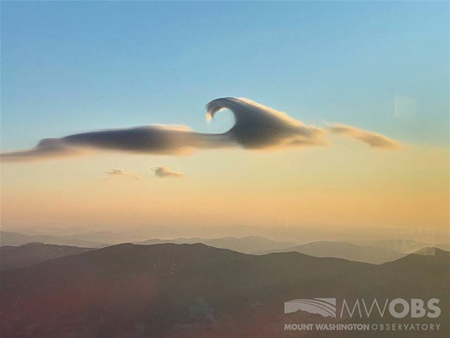
A Lenticular Cloud With a Curl
Lens-shaped lenticular clouds are not terribly rare in mountainous areas, but observers at Mount Washington caught a very unusual cloud near sunrise in late February. This lenticular cloud had an added curl on top thanks to the Kelvin-Helmholtz instability!
Lenticular clouds form when air is forced to flow up over a mountain in such a way that its temperature and pressure drop and water vapor in the air condenses. The resulting water droplets form a cloud that appears stationary over the mountain, even though the air continues to flow.
To get that added wave-like curl, there needs to be another, faster-moving layer of air just above the cloud. As that air flows past, it shears the cloud layer, causing the interface to curl. Neither of these cloud types is long-lived — Kelvin-Helmholtz formations often last only a few minutes — so catching such a great dual example is lucky, indeed! (Image credit: Mount Washington Observatory; via Smithsonian Magazine; submitted by Kam-Yung Soh)

Wave Clouds in the Front Range
Last Sunday night metro Denver was treated to a rare sight: clouds resembling breaking waves formed near sunset. These are Kelvin-Helmholtz clouds, and the comparison to ocean waves is apt, since the same physics is behind both. Winds were unusually calm near the ground Sunday night, but strong winds blew at the altitude just above the lower cloud layer. That velocity difference created strong shear where the two air layers met. With the cloud layer in place to differentiate the slower-moving air from the faster, we can what’s normally invisible: how the two air layers mix.
The Denver Post has several more views of the wave clouds from around the area, and you can learn lots more about the Kelvin-Helmholtz instability here. (Image credit: R. Fields; via the Denver Post)

Jupiter’s Atmosphere
Jupiter’s atmosphere is fascinatingly complex and stunningly beautiful. This close-up from the Juno spacecraft shows a region called STB Spectre, located in Jupiter’s South Temperate Belt. The bluish area to the right is a long-lived storm that’s bordering on very different atmospheric conditions to the left. Shear from these storms moving past one another creates many of the curling waves we see in the image. These are examples of the Kelvin-Helmholtz instability, which generates ocean waves here on Earth, creates spectacular clouds in our atmosphere, and is even responsible for waves in galaxy clusters. Check out some of the other amazing images Juno has sent back of our solar system’s largest planet. (Image credit: NASA/JPL-Caltech/SwRI/MSSS/R. Tkachenko; via Gizmodo)

Shear Across the Water
This photo series shows the development of a Kelvin-Helmholtz instability. It’s formed when two layers of fluid move past one another at different speeds. In this case, the two fluids meet off the back of a flat plate (seen at the left of the top image) when fast-moving flow from the top of the plate encounters slower fluid beneath. Friction and shear between the fluid layers causes billows to rise up and form waves very similar to those on the ocean (wind across the water works the same way!). Those waves turn over into vortex-like spirals and keep mixing until they break down into turbulence. This pattern crops up pretty frequently, especially in clouds. (Image credit: G. Lawrence)

Waves Over the Rockies
These spectacular wave-like clouds are the result of the Kelvin-Helmholtz instability. When two layers of air move past one another at different velocities, an unstable shear layer forms at their interface. Disturbances in this shear layer grow exponentially, creating these short-lived overturning waves that quickly turn turbulent. The strong resemblance of these clouds to breaking ocean waves is no coincidence–the Kelvin-Helmholtz instability occurring between the wind and water is what generates many ocean waves. Kelvin-Helmholtz patterns are also common on other planets, like Jupiter, Saturn, and Mars. (Image credit: Breckenridge Resort; submitted by jshoer)

Wave Clouds Over the Galapagos
This dramatic example of Kelvin-Helmholtz clouds was taken near the Galapagos Islands last week. The shark-fin-like clouds are the result of two air layers moving past one another. The velocity difference at their interface creates an unstable shear layer that quickly breaks down. The resemblance of the clouds to breaking ocean waves is no coincidence – the wind moving over the ocean’s surface generates waves via the same Kelvin-Helmholtz instability. In the case of the clouds above, the lower layer of air was moist enough to condense, which is why the pattern is visible. Clouds like these don’t tend to last for long because the disturbances that drive the instability grow exponentially quickly, leading to turbulence. (Image credit: C. Miller; via Washington Post; submitted by @jmlinhart)
——————
Help us do some science! I’ve teamed up with researcher Paige Brown Jarreau to create a survey of FYFD readers. By participating, you’ll be helping me improve FYFD and contributing to novel academic research on the readers of science blogs. It should only take 10-15 minutes to complete. You can find the survey here.

Measuring Wind Speed by Satellite
Weather modeling and forecasting in recent decades have benefited enormously from the availability of more data. For example, satellites now measure wind speeds over the open ocean, instead of data simply coming from isolated ships and buoys. The satellites do this by measuring the roughness of the ocean using radar or GPS signals bounced off the ocean surface. From this researchers can construct a map of wave height and direction like the one in the animation above. For a large body of water, waves are primarily generated by wind shearing the water at the interface. The waves we see are a result of the Kelvin-Helmholtz instability between the wind and ocean. Because this is a well-known behavior, it is possible to connect the waves we observe with the wind conditions that must have generated them. (Image credit: ESA; animation credit: Wired; submitted by jshoer)

Shocked Interfaces
The Richtmyer-Meshkov instability occurs when two fluids of differing density are hit by a shock wave. The animation above shows a cylinder of denser gas (white) in still air (black) before being hit with a Mach 1.2 shock wave. The cylinder is quickly accelerated and flattened, with either end spinning up to form the counter-rotating vortices that dominate the instability. As the vortices spin, the fluids along the interface shear against one another, and new, secondary instabilities, like the wave-like Kelvin-Helmholtz instability, form along the edges. The two gases mix quickly. This instability is of especial interest for the application of inertial confinement fusion. During implosion, the shell material surrounding the fuel layer is shock-accelerated; since mixing of the shell and fuel is undesirable, researchers are interested in understanding how to control and prevent the instability. (Image credit: S. Shankar et al.)The APS Division of Fluid Dynamics conference begins this Sunday in Pittsburgh. I’ll be giving a talk about FYFD Sunday evening at 5:37pm in Rm 306/307. I hope to see some of you there!

Viscoelastic Jets
Unlike Newtonian fluids, such as air and water, viscoelastic fluids exhibit non-uniform reactions to deformation. In this video, researchers explore the effects of this behavior when a liquid jet falls into another fluid. When fluids move past one another at different speeds in this manner, there is a shearing force which often leads to the wave-like Kelvin-Helmholtz instability between the fluids. Here we see for a variety of wavelengths how the breakdown of a Newtonian and viscoelastic jet differ. The Newtonian jets form clean lines and complicated tulip-like shapes, but the viscoelasticity of the non-Newtonian jets inhibits the growth of these instabilities, surrounding the central jet with wisps of escaping fluid. For more, see Keshavarz and McKinley. (Video credit: B. Keshavarz and G. McKinley)