Tag: weather

  • Featured Video Play Icon

    Rivers in the Sky

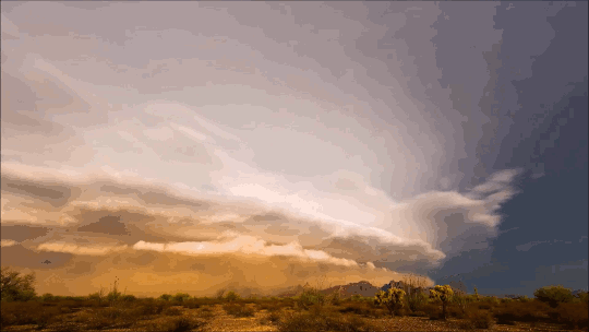
    The water cycle is quite a bit more complicated than what we learn in elementary school, and the environment around us contributes to that cycle in invisible but vital ways. In this video, Joe Hanson of It’s Okay to Be Smart pulls back the veil on this in the context of the Amazon river basin and how the Amazon rainforest itself creates an atmospheric river that carries more water than its namesake river.

    Trees release water into the air almost constantly as they transpire. And to trigger that water to fall as rain, trees can release other compounds that serve as a nucleus around which raindrops can form. The condensing raindrops form clouds, which lower the air pressure and create winds, thereby creating an atmospheric river flowing from the Atlantic back up the Amazon River. That stream carries rain that feeds the rainforest and the Amazon River, continuing the cycle. (Video and image credit: It’s Okay to Be Smart)

  • Turbulent Skies

    Turbulent Skies

    The atmosphere above us is a thin layer enclosing our planet, but it roils with activity and energy. Photographer Camille Seamon captures the grandeur of our turbulent skies in her storm shots. These dramatic atmospheric vistas – including mammatus clouds (top), swirling supercells (middle), and turbulent storm clouds (bottom) – are all driven by the flow of heat and moisture. (Image credit: C. Seaman; via Colossal)

  • Growing Droplets

    Growing Droplets

    The moisture in clouds eventually condenses into droplets that grow into raindrops and fall. Some steps in this process are well understood, but others are not. In particular, scientists have struggled with the problem of how droplets grow from about 30 microns to 80 microns, where they’re big enough to start falling and merging.

    Laboratory experiments and numerical simulations (below) have shown that turbulence can help drive small water drops together. When droplets are tiny and light, they simply follow the air flow. But when they’re a little heavier, turbulent eddies (seen in orange below) act like miniature centrifuges, flinging larger water droplets (shown in cyan below) out into clusters, where they’re more likely to collide with one another.

    Although this effect has been seen in experiments and simulation, it’s been difficult to capture in clouds themselves. But a new set of test flights (above) confirms that this mechanism is present in the wild as well! (Image credit: UCAR/NCAR Earth Observing Laboratory, P. Ireland et al., source; research credits: M. Larsen et al., P. Ireland et al.; via APS Physics; submitted by Kam-Yung Soh)

    image
  • Featured Video Play Icon

    The Show in the Sky

    There is a constant drama playing out overhead, though most of us do not take the time to watch. Fortunately, a few, like Blaž Šter, do and make timelapse videos that allow us to enjoy hours of atmospheric drama in only a few minutes. This timelapse shows a cloudy and rainy mid-July day in Slovenia, where an unstable atmosphere leads to turbulent and dramatic clouds. In an unstable atmosphere, it’s easier for vertical motion to take place between altitudes. For example, a parcel of warm air displaced upward will continue to rise because it will be lighter and more buoyant than the surrounding air. This is key to the strong convection that can generate thunderstorms. (Image and video credit: B. Šter, source)

  • Pyrocumulus on the Horizon

    The Cranston wildfire in California is intense enough that it’s creating its own weather. This timelapse video shows the formation and growth of a pyrocumulus cloud, also associated with volcanoes, over the wildfire. In both instances, the extreme heat causes a massive column of hot, turbulent air to rise. Because ash and smoke are carried upward as well, there are many places for any moisture in the atmosphere to nucleate, forming the cloud we see. In timelapse, the roiling nature of the air’s motion is especially apparent. This turbulence can be dangerous, as it may contribute to high winds and even lightning, both of which can spread the fire further. (Video credit: J. Morris; via James H.)

  • Snowmelt

    Snowmelt

    Much of the rain that falls on Earth began as snow high in the atmosphere. As it falls through warmer layers of air, the snowflakes melt and form water droplets. The details of this melting process have been difficult to capture experimentally, but a new computational model may provide insight. The basic process has a couple stages. As snow begins to melt, surface tension draws the water into concave areas nearby. When those regions fill up, the water flows out and merges with neighboring liquid, forming water droplets around a melting ice core.

    Although this same sequence was observed for many types of snow, scientists also observed some important differences between rimed and unrimed snowflakes. Rime forms when supercooled water droplets freeze onto the surface of a snowflake. Lightly rimed snow still looks light and fluffy, like the animation above, but heavily rimed snow forms denser and more spherical chunks. Because there are lots of porous gaps in heavily rimed snow, water tends to gather there during initial melting. Rimed snow was also more likely to form one large water droplet rather than breaking into multiple droplets like snow with less rime. For more, check out NASA’s video and the Bad Astronomy write-up. (Image credit: NASA, source; research credit: J. Leinonen and A. von Lerber; via Bad Astronomy; submitted by Kam Yung-Soh)

  • Featured Video Play Icon

    “Monsoon IV”

    It’s a cliché to claim that the sky is bigger in the American West, but the wide, open views in that region do offer a very different perspective on weather. Photographer Mike Olbinski’s works give viewers a taste of that perspective of far-off thunderstorms, towering anvil clouds, and massive downpours in the distance. At the same time, many of his sequences illustrate the birth and death of these massive storms. As warm, moist air rises, a puffy cumulus cloud (below) swells upward as fresh moisture condenses. When it reaches a thermal cap and can rise no further, precipitation begins to fall, dragging surrounding air with it. This is the mature stage of a storm, when both updrafts and downdrafts exist simultaneously.

    Eventually, the storm’s power begins to wane as the downdrafts cut off the updrafts that feed the storm. Sometimes this occurs in a massive downdraft where cool air sinks straight down and, upon encountering the ground, spreads radially outward. In dry regions, this outward burst of ground-level winds can pick up dirt, dust, and sand, forming a wall-like haboob (below) that advances past the remains of the storm. Watch the entire video to see some examples in their full glory! (Video and image credit: M. Olbinski, source; via Rex W.)

    image
  • Creating Clouds

    Creating Clouds

    Despite their ubiquity and importance, we know surprisingly little about how clouds form. The broad strokes of the process are known, but the details remain somewhat fuzzy. One challenge is understanding how nucleation – the formation of droplets that become clouds or rain – works. A recent laboratory experiment in an analog cloud chamber suggests that falling rain drops may help spawn more rain drops.

    The experiment takes place in a chamber filled with sulfur hexafluoride and helium. The former acts like water in our atmosphere, appearing in both liquid and vapor forms, while the latter takes the place of dry components of our atmosphere, like nitrogen. The bottom of the chamber is heated, forming a liquid layer of sulfur hexafluoride, seen at the bottom of the animation above. The top of the chamber is cooled, encouraging sulfur hexafluoride vapor to condense and form droplets that fall like rain. A top view of the same apparatus during a different experiment is shown in this previous post.

    When droplets fall through the chamber, their wakes mix cold vapor from near the drop with warmer, ambient vapor. This changes the temperature and saturation conditions nearby and kicks off the formation of microdroplets. These are the cloud of tiny black dots seen above. Under the right conditions, these microdroplets grow swiftly as more vapor condenses onto them. In time, they grow heavy enough to fall as rain drops of their own. (Image credits: P. Prabhakaran et al.; via APS Physics; submitted by Kam-Yung Soh)

  • Featured Video Play Icon

    “Monsoon II”

    Every child learns about the water cycle in school, but an academic description of the process often lacks nature’s grandeur. In “Monsoon II” photographer Mike Olbinski captures the majesty of cloud formation and rainfall in a way that rekindles awe for the scale of the process. It begins with bright clouds popping up, the result of warm moist air rising from the ground and cooling at altitude. As more water vapor evaporates, rises, and condenses, water droplets collide in these clouds, coalescing and growing until they grow too large and heavy to stay aloft. These are the droplets that fall in sheets of rain, blurring the air beneath them. There’s an incredible beauty to watching rain fall from a distance; it looks calm and localized in a way that’s utterly at odds with the experience from inside the storm. (Video credit: M. Olbinski; submitted by jshoer)

  • Featured Video Play Icon

    “The Chase”

    Sometimes it takes timelapse photography to truly appreciate the dynamic behavior of our atmosphere. In “The Chase” Mike Olbinski, whose work we’ve featured previously, has captured some of the most incredible and stunning weather timelapse footage I have ever seen. Despite watching it repeatedly, I continue to be awed to the point that I have no words. Seriously, just watch it. Be amazed by the drama of our sky. (Video credit: M. Olbinski)