Tag: meteorology

  • Predicting Meteotsunamis

    Predicting Meteotsunamis

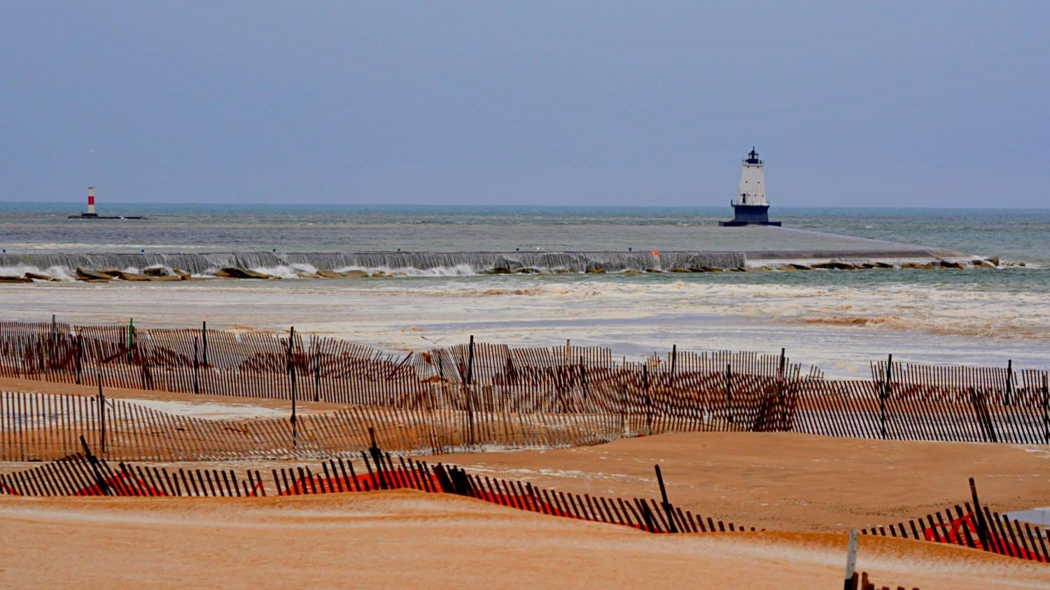
    Meteotsunamis, or meteorological tsunamis, are large waves driven by weather rather than seismic energy. Although they occur along shorelines throughout the world, forecasters have very little infrastructure in place to predict or detect them. But a new study of an April 2018 meteotsunami on Lake Michigan (pictured above) has provided evidence that existing models may be able to forecast these events.

    The Lake Michigan meteotsunami was driven by an atmospheric gravity wave, which carried with it a substantial pressure drop. Most of the time such waves travel faster or slower than water waves, and there is little to no interaction. But on this day, the atmospheric wave and the water waves were traveling at the same speed in the same direction, creating a resonance that strengthened the water wave.

    Using existing National Oceanic and Atmospheric Administration (NOAA) models, researchers were able to reconstruct the event digitally, with results that agreed well with observations. That success means that forecasters may be able to predict the events ahead of time, potentially saving lives. (Image credit: D. Maglothin; research credit: E. Anderson and G. Mann; via Gizmodo)

  • Fallstreak Holes

    Fallstreak Holes

    Occasionally clouds appear to have a hole in them; these are known as fallstreak holes or hole-punch clouds. To form, the water droplets in the cloud must be supercooled; in other words, they must be colder than their freezing point but still in liquid form. When disturbed — say, by the temperature drop caused by flowing over an airplane wing — the supercooled water droplets will suddenly freeze. This typically kicks off a chain reaction in which many droplets freeze and the heavy ice crystals fall out of the sky, leaving behind a void in the cloud. Because airplanes are particularly good at creating these fallstreak holes, they’re often seen near busy airports. (Image credit: J. Stevens/NASA; via NASA Earth Observatory)

  • Blue Jets

    Blue Jets

    Blue jets are a mysterious form of lightning that shoots upward from intense thunderstorms. The image above comes from one of the first color videos of blue jets, taken by an astronaut aboard the International Space Station. Scientist think blue jets form during an electric breakdown between the positively-charged upper region of a cloud and the negative charge at its boundary. Once the discharge starts, it can shoot to the stratopause in less than a second, forming a glowing, blue, nitrogen-based plasma. (Image credit: ESA/NASA/DTU Space; via NASA Earth Observatory)

  • Featured Video Play Icon

    Chasing Tornadoes

    Tornadoes are some of the most powerful storms on Earth. Their difficult-to-predict nature means that we still have a relatively scant understanding of exactly how they form. We know the conditions that promote their development — warm, moist rising air, wind shear, and rotation — but how and when those translate into a dangerous funnel cloud is harder to pin down. In this video, we hear from one of National Geographic’s storm researchers, Anton Seimon, who chases these storms in search of answers. (Image and video credit: National Geographic)

  • Featured Video Play Icon

    “Monsoon 6”

    The stunning power and beauty of our atmosphere comes to life in Mike Olbinski’s latest short film, “Monsoon 6”. Over the years, I’ve probably watched dozens of Olbinski’s videos, yet he still captures sequences that make me exclaim aloud as I watch. In this one, some of my favorites are the microburst at 2:17 and the development of mammatus clouds at 3:20. How mammatus clouds form is still very much an area of active research; I don’t know if Olbinski’s footage sheds light on their formation, but it is supremely awesome to watch! (Image and video credit: M. Olbinski)

  • Featured Video Play Icon

    The Great Haboob Chase

    Few sights look as apocalyptic as the leading edge of an incoming dust storm. Known as a haboob, these storms form when a downdraft spreads along the ground, picking up loose dust as the storm front advances. Winds inside the haboob can be severe; when one swept through Denver last year, my first clue was the trees outside my window whipping back and forth wildly, followed by the sky going dark and brownish. Photographer Mike Olbinksi’s short film offers a far better vantage, letting viewers appreciate the towering cloud as it bears down. (Video and image credit: M. Olbinski)

  • Stratospheric Effects of Wildfires

    Stratospheric Effects of Wildfires

    Australia’s bushfires from earlier this year are offering new insights into how pyrocumulonimbus clouds can affect our stratosphere. A massive, uncontrolled blaze between December 29th and January 4th generated a towering, turbulent cloud of smoke like the one shown above.

    Using meteorological data, a new study shows this enormous cloud initially rose to 16 km in altitude, then began a months-long trek that circled the globe. The smoke plume ultimately stretched to over 1,000 km wide and reached a record altitude of over 31 km. Inside the plume, concentrations of water vapor and carbon monoxide were several hundred percent higher than normal stratospheric air.

    Researchers found the plume extremely slow to dissipate, possibly due to strong rotational winds surrounding it. This is the first time scientists have observed these shielding winds, and work is still underway to determine how and why they formed. (Image credit: M. Macleod/Wikimedia Commons; research credit: G. Kablick III et al.; via Science News; submitted by Kam-Yung Soh)

  • As the Fog Rolls In

    As the Fog Rolls In

    Although we talk about fog rolling in, it’s rare for us to have a perspective where we can truly appreciate that flow. But this photograph from Tanmay Sapkal provides just that for the low summer fogs sweeping over Marin, CA. When hot summer temperatures make inland air rise, cold, moist air from the ocean sweeps in to replace it. Once the moisture condenses, it forms thick, low clouds of fog that surge past the Golden Gate Bridge and into San Francisco Bay. (Image credit: T. Sapkal; via NatGeo)

  • Featured Video Play Icon

    “Vorticity 3”

    Mike Olbinski’s “Vorticity 3” is a stunning view of storm chasing in the American West. I’ve learned after years in Colorado to always look up because dramatic skies are common here, as is seeing rain falling miles away. Olbinski’s film captures all of that grandeur and more, giving all of us a glimpse inside the incredible storms that mark the summer months in this region. You’ll see spinning supercell thunderstorms, bulbous mammatus clouds, towering cumulus clouds, and more. (Video and image credit: M. Olbinski)

  • Tornadoes of the Sea

    Tornadoes of the Sea

    This dramatic image shows a waterspout formed off the coast of Florida. Waterspouts come in two varieties: tornadic and fair-weather. Both types can be dangerous to anyone caught up in them, though the tornadic variety, which are usually associated with severe thunderstorms, is generally worse. Tornadic waterspouts can form top-down from a thunderstorm or when a tornado moves from land to water. Fair-weather waterspouts, on the other hand, typically form from the bottom, in a similar fashion to dust devils and other fair-weather vortices. (Image credit: J. Mole; via APOD)