
Photographer Mike Olbinski has captured a spectacular timelapse of a supercell thunderstorm over the plains of Texas. Supercells are characterized by a strong, rotating updraft known as a mesocyclone, seen clearly in the video. These storms are commonly isolated occurrences, forming when horizontal vorticity in the form of wind shear is redirected upwards by an updraft. Such a strong updraft is typically created by a capping inversion, a situation where a layer of warmer air traps the colder air beneath it. (This is why one sees a distinctive cut-off at the top of some clouds.) As warm air rises from the surface, either the air above the cap will cool or the air below the cap will warm. Either situation results in an instability with cooler air on top of warmer air, providing a catalyst for the kind of dramatic weather seen here. (Video credit: M. Olbinski; via io9)
Tag: meteorology

Saturn’s Great White Spot
We’ve touched a couple times on Saturnian storms, but this NASA video gives a great overview of the Great White Spot, a storm that appeared in late 2010. Gauging the fluid dynamics of gas giants like Saturn and Jupiter is difficult, in large part because we can see only the outermost portion of the atmosphere. Numerous theories and models have been suggested to explain features and dynamics that we observe, but much of the overall behavior remains a subject of debate among planetary scientists. (Video credit: NASA Goddard)

Reader Question: Frosty Cars
Reader Mike L asks:
Why do I never see frost on my car when I park in a detached garage or under a carport?Great question! Frost forms on surfaces when their temperature drops below the freezing point of water and the dew point of the surrounding air. The water vapor in the air gets deposited as a solid directly; this is called deposition. This means that the surface–in this case your car–has to be colder than the nearby air. Neither conduction nor convection of heat between your car and the surrounding air can cause this drop; heat transfer between your car and the surrounding air would tend to make them the same temperature, not make the car colder than the air. The third–and typically least effective–type of heat transfer, radiation, is the answer because it allows heat transfer between two objects that are not in direct contact like the air and car are.
Frost typically forms on still, clear nights with little clouds or wind. A car sitting beneath a clear night sky will radiate heat out into space. Since space is much, much colder than the air, this radiation cooling to space allows the car’s surface temperature to drop below that of the surrounding air, which is not a good radiator by comparison. On a night with little wind (and thus little convection), this radiation cooling can be quite effective. Frost will tend not to form on one’s car under a carport because the car is sheltered from the night sky, blocking such radiative cooling. Having a tree or house blocking the car from the night sky is also effective at preventing frost formation. (Photo credit: N. Sharp; with thanks to Keri B and Jerry N for the meteorological assistance)
Atmospheric Dynamics in the Lab
One way to explore some of the large-scale atmospheric dynamics we observe here on earth is through table-top demonstrations such as this one. Here a platform with a water tank is rotating at a constant velocity. The camera rotates with the tank; this is why the hand in the video seems to spin. At the center of the tank, ice in a can cools the water, while the warmer air along the periphery provides heating. The green dye marks initially cooler fluid while the red dye marks the warmer fluid from the outside of the tank. The dense cooler fluid sinks and moves outward while warmer water moves in to replace it. This creates radial circulation; the thermal gradients and rotation cause the eddies and jets seen from this top view, in much the same way that they form in the mid-latitudes of earth’s atmosphere. (Video credit: Marshall Lab, MIT)

Volcanic Vortices
The volcanoes of the South Sandwich Islands, located in the South Atlantic, have a notable effect on cloud formation in this satellite photo. Visokoi Island, on the right, sheds a wake of large vortices that distort the cloud layer above it. On the left, Zavodovski Island’s volcano does the same, with the added effect of low-level volcanic emissions, which include aerosols. These tiny particles provide a nucleus around which water droplets form, causing an marked increase in cloud formation visible in the bright tail streaming off the island. (Photo credit: NASA, via Earth Observatory)

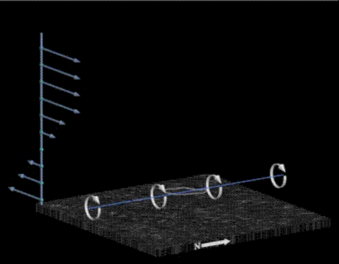
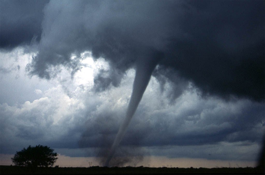
Tornadogenesis

Tornadogenesis–the formation of tornadoes–remains a topic of active research as there is relatively little direct experimental data, owing to the difficulty of prediction as well as measurement. Initially, a variation of wind speed at different altitudes in the atmosphere causes shearing, which can lead to the formation of a horizontal column of rotating air–a vortex line similar to a roll cloud. Beneath a developing storm, the updraft of warm local air can pull this vortex line upwards, creating vertical rotation in the cloud, thereby birthing a supercell. Supercells do not always spawn tornadoes, and the exact causes that result in tornadic or nontornadic supercells are not fully understood. However, the formation of tornadoes within the supercell seems dependent on the downdraft of cool air within the storm as well as stretching of the vortex line, which increases its rate of rotation. For more information, check out this explanatory video and some of the talks by Paul Markowski. (Thanks to mindscrib, aggieastronaut and others for their submissions related to this topic! Photo credits: P. Markowski and D. Zaras)

Winds Across the US

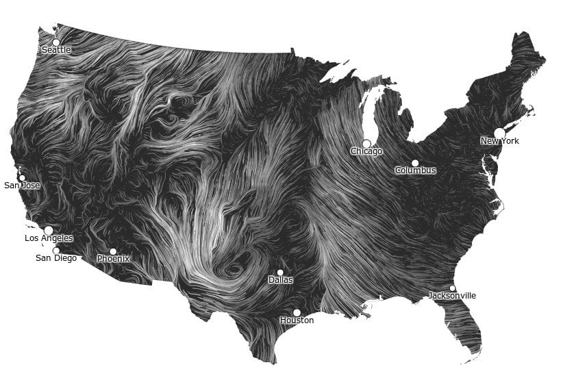
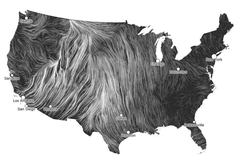
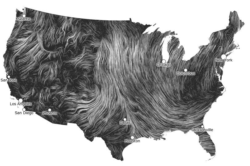
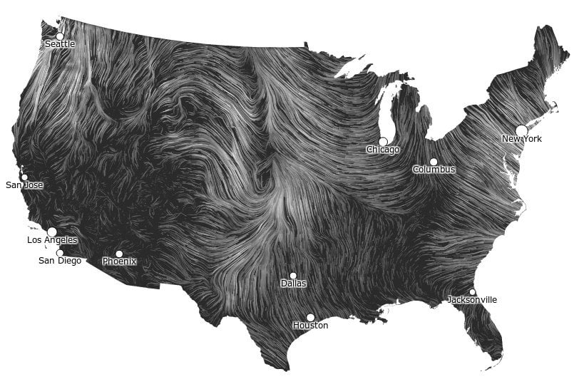
A collaborative project on data visualization brings to life the wind velocity data across the United States. The Wind Map is an interactive, nearly real-time indicator of wind conditions across the country, compiled on an hourly basis from the National Digital Forecast Database. Be sure to click through to see the data in motion. Observing the variety in wind patterns over the scale of days brings to light the swirling motion of surface winds much the way Perpetual Ocean does for surface currents. Fluid dynamics are all around us. (via Gizmodo)

Cloud Swirls
Two interesting sets of clouds are featured in this satellite photo of the Canary Islands and the coast of Africa. In the upper part of the picture, closed cell stratocumulus clouds cover the ocean. As the wind drives these clouds over the islands, their pattern is disturbed by mountains that force the lower layers of air up and around, forming von Karman vortices and wakes that mingle and twist the cloud patterns to the south of the islands. (Photo credit: European Space Agency; via Wired)

Wave Clouds Over Alabama
Last week, Birmingham, Alabama got treated to a special cloudy day, thanks to some Kelvin-Helmholtz waves, shown above. When a layer of faster moving fluid shears a slower moving fluid, this instability can form and cause some spectacular mixing. In this case, the lower, slower fluid was cool and moist enough to contain clouds, enabling us to see the effect with the naked eye. The same mechanism is responsible for the shape of breaking ocean waves and can even be seen in the atmospheres of gas giants like Saturn and Jupiter. (submitted by David B)
Brinicles
In the frozen reaches of our planet, the atmosphere and ocean can interact in bizarre ways. Under calm ocean conditions when the air at sea level is much colder than the water temperature brinicles–the underwater equivalent to an icicle–can form. The cold air above rapidly freezes ocean water at the surface, concentrating water’s salt content into a very cold brine which sinks rapidly. As this brine descends, it freezes the water around it into an ice sheath. As the brinicle grows and eventually reaches the sea floor, its cold temperatures can wreak havoc on the creatures living there.


