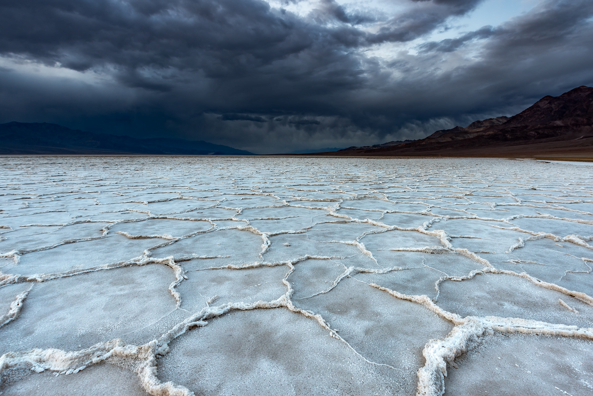
Tag: geophysics

  • The Chicxulub Impact’s Tsunami

    The Chicxulub Impact’s Tsunami

    66 million years ago an asteroid struck offshore of what is now Chicxulub near the Yucatán Peninsula in Mexico. The impact and its aftermath are widely credited with a mass extinction that wiped out 75% of plant and animal life on Earth, including non-avian dinosaurs. Since the impact occurred in shallow waters, it also generated a tsunami, one over 30,000 times bigger than any in recorded history.

    Snapshot showing the spreading tsunami after the asteroid's impact.
    Snapshot showing the spreading tsunami after the asteroid’s impact. Click on the image to go to NOAA’s website and watch the video.

    In this simulation, researchers show how that tsunami spread globally. The initial wave was about a mile high but stretched up to about 2.5 miles as it rushed ashore. Worldwide, every shoreline saw flows at 20 cm/s or higher as the wave hit. In the image above, black areas show the landmasses as they existed at the time, with modern borders shown in white outline. To watch the video, click on the image or head to NOAA’s visualization.

    You may wonder how scientists can validate a simulation like this one, which so wildly exceeds any recorded event. One way they judged these results is by looking at the sedimentary records of the seafloor. Their results show flows large enough to scour the seafloor and disrupt any sedimentary records in those areas, and, sure enough, those regions hold no records older than the asteroid’s impact. That alignment between the geological record and the simulation’s highest flow areas helps establish confidence in the results. (Image credit: illustration – SWRI/D. Davis, simulation – NOAA; research credit: M. Range et al.; submitted by Kam-Yung Soh)

  • Turning the Beach Pink

    Turning the Beach Pink

    Lab experiments and numerical simulations can only take us so far; sometimes there’s no substitute for getting out into the field. That’s why a beach in San Diego turned pink this January and February, as researchers released a safe, non-toxic dye into an estuary. The goal is to understand how small freshwater sources mix with colder, saltier ocean waters when they meet in the surf zone. Differences in temperature and salinity both affect the waters’ density and, therefore, how they’ll combine, especially in the face of the turbulent surf. Using drones, distributed sensors, and a specially-outfitted jet ski, the researchers collect data about how the dye (and therefore the estuary’s water) spreads over the 24 hours following each dye release. Check out their experiment’s site to learn more. (Image credits: E. Jepsen/A. Simpson/UC San Diego; via SFGate; submitted by Emily R.)

  • Slab Avalanche Physics

    Slab Avalanche Physics

    Slab avalanches like the one shown here begin after weak, porous layers of snow get buried by fresher, more cohesive snow layers. On a steep slope, the weight of the new snow can be too great for friction to hold the slab in place, causing the upper layer to crack and slide at speeds up to 150 meters per second. Scientists had two competing theories for how slab avalanches began. One theory presumed that the weak layer of snow failed under shear; the other argued that the collapse of the lower, porous layer was at fault.

    In a new study combining large-scale numerical simulation with real-life observations, scientists came to a new conclusion: cracks began to form in the porous layer as the weight of heavier snow crushed down, but once the cracks formed, the shear mechanism took over. Cracks formed by shear could propagate along the existing cracks in the porous layer, allowing faster crack propagation than through undamaged snow. In the end, it’s the combination of the two mechanisms that triggers the avalanche. (Image credit: R. Flück; research credit: B. Trottet et al.; via Physics World)

  • Vietnam’s Emerald Isles

    Vietnam’s Emerald Isles

    Vietnam’s Hạ Long Bay is home to more than 1,600 islands, many of them made up of mountainous limestone. The area is famous for its karst features, a type of terrain formed from highly porous, water-soluble rock. Over time, water dissolves and fractures the limestone, creating karst landscapes full of caves, springs, sinkholes, and fluted rock outcroppings. The area’s erosion also produces highly fertile soil, leading to a verdant ecosystem with many unique and endemic species. (Image credit: N. Kuring/NASA/USGS; via NASA Earth Observatory)

  • Landslide-Triggered Tsunamis

    Landslide-Triggered Tsunamis

    After the 2018 Anak Krakatoa eruption, a tsunami that ricocheted through the surrounding waters, killing hundreds on nearby islands. The source of that tsunami was a small landslide. Once the air cleared and researchers could assess how much material slid into the ocean, they were shocked that such a small volume created so much destruction.

    Now new efforts are revealing the linkage between landslides and the waves they make. Researchers released glass beads into a tank of water, observing the waves that form as the beads run out. Depending on the relative initial height of the beads compared to the water depth, they observed three different kinds of waves. Not only that, they were able to connect the granular mechanics of the landslide to the hydrodynamic formation of waves, allowing predictions of the waves that will form for a given landslide.

    Currently, the predictive model isn’t sophisticated enough to handle a geometry as complex as that of the Anak Krakatoa landslide, but it’s an important step toward understanding — and potentially mitigating the damage of — future oceanside landslides. (Image and research credit: W. Sarlin et al.; via APS Physics; submitted by Kam-Yung Soh)

  • Martian Glaciers

    Martian Glaciers

    On Earth, glaciers slide on lubricating layers of water, leaving complex landscapes like fjords and drumlins in their wake. Mars — though once home to enormous ice masses — lacks those geological features. Scientists assumed, therefore, that Martian ice stayed frozen and unmoving. But a new study demonstrates that is not the case.

    Researchers used computational modeling to simulate two identical glaciers: one under Earth-like conditions and one under the lower gravity of Mars. They found that Martian glaciers did indeed move, but Mars’s lower gravity, combined with better water drainage beneath the ice, meant that they moved exceedingly slowly. Martian glaciers did erode the landscape but into different features than on Earth. Instead of forming moraines and drumlins, a large Martian glacier would instead carve channels and eskar ridges, geological features found on Mars today. (Image credit: NASA/JPL-CalTech/Uni. of Arizona; research credit: A. Grau Galofre et al.; via AGU; submitted by Kam-Yung Soh)

  • Predicting Alien Ice

    Predicting Alien Ice

    Europa is an ocean world trapped beneath an ice shell tens of kilometers thick. To better understand what we might find in those oceans, researchers turn to analogs here on Earth, looking at Antarctica’s ice shelves. Beneath those shelves, ice forms via two mechanisms: the first, congelation ice, freezes directly onto the existing ice-water interface. The second, frazil ice, forms crystals in supercooled water columns, which drift upward in buoyant currents and settle on the ice shelf like upside-down snow (pictured above).

    Based on Europa’s conditions, the researchers conclude that congelation ice would gradually thicken the ice shell as the moon’s interior cools. But in areas where the shell is thinned by local rifts and Jovian tidal forces, frazil ice is likely to form. (Image credit: H. Glazer; research credit: N. Wolfenbarger et al.; via Physics World)

  • Eroding Grains

    Eroding Grains

    When a spacecraft comes in for a landing (or a tag similar to what OSIRIS-REx did), there’s a turbulent jet that points straight into a bed of particles. How those particles react — how they erode and the crater that forms — depends on many factors, including the cohesion between particles. In these experiments, researchers investigated such a jet (in air) and its impact on particles with differing amounts of cohesion.

    When there is little cohesion between particles, erosion takes place a single particle at a time (Image 1). Once there’s some cohesion, the jet’s velocity has to be higher to trigger erosion (Image 2). Once erosion does begin, it includes both singular and clumped particles. In highly cohesive beds, velocities must be even higher to create erosion, which takes place with large clusters of particles flying off together (Image 3). (Image and research credit: R. Sharma et al.)

  • When Rivers Jump

    When Rivers Jump

    Avulsions — sudden changes in the course of a river — are a river’s equivalent of an earthquake, and they can be similarly devastating for those in the river’s path. In a recent study, authors combed through 50 years’ worth of satellite data to catalog over 100 avulsions and categorize them into three regimes. About a quarter of the observed avulsions took place in the river delta’s fan, where the river spreads out once it exits a canyon or valley. These avulsions, they found, occur when rivers lose confinement and sediment can build up.

    This animation of satellite images shows the sudden avulsion -- a dramatic change in the river's course -- that took place on the Kosi River in 2008.
    This animation of satellite images shows the sudden avulsion — a dramatic change in the river’s course — that took place on the Kosi River in 2008.

    Among the other observations, the team linked avulsion location to the river’s flow properties. Most of these remaining avulsions took place in the river’s backwater region, where the river begins to slow down before its outlet. The last category of avulsion took place far upstream of the backwater region on rivers with high sediment flows. During flood conditions, erosion can travel far upstream on these rivers, causing avulsions in unexpected places. Changes in sediment load due to human activities, like deforestation, could even cause rivers to change from the backwater regime to the high-sediment load one. (Image credit: top – R. Simmon/USGS, bottom – S. Brooke et al.; research credit: S. Brooke et al.; via AGU Eos; submitted by Kam-Yung Soh)

  • Featured Video Play Icon

    How Dunes Form

    On its face, the idea that sand and wind can come together to form massive mountainous dunes seems bizarre. But dunes — and their smaller cousins, ripples — are everywhere, not just on Earth but on other planetary bodies where fine particles and atmospheres interact. In this video, Joe Hanson gives a great overview of sand dynamics, beginning with what sand is, how it moves, and what it can ultimately form. It’s well worth a watch, even if you know a little about dunes already; I know I learned a thing or two! (Image and video credit: Be Smart)