Taken from a Cessna aircraft, photographer J. Fritz Rumpf’s image of a Brazilian landscape appears abstract. But it captures a serpentine river and surrounding dunes, dyed brown by decaying plant matter and sculpted by the forces of wind and current. This shot is part of a portfolio that won him the title of 2025 International Landscape Photographer of the Year. (Image credit: J. Rumpf; via ILPOTY)
Tag: erosion

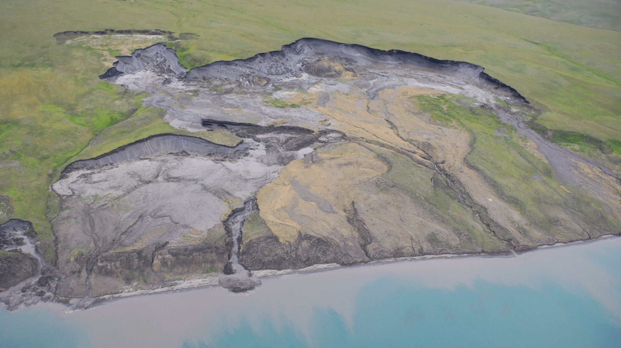
Thawing Permafrost Primes Slumps
As permafrost thaws on Arctic hillsides and shorelines, the land often deforms in a unique fashion, known as a slump. Formally known as mega retrogressive thaw slumps, these areas superficially resemble a landslide. They’re also prone to repeat performances: as many as 90% of Canada’s Arctic slumps recur in the same place as previous slumps. Researchers used ground-penetrating radar and other tools to study the underground structure at slumps and found that several factors contribute to this repetitive cycle.
Seawater soaking into the foot of a hilly shore can destabilize the permafrost, creating a slump. That changes the nearby ground cover, exposing more permafrost to warming; their measurements showed this warming could extend tens of meters underground, priming the area for future slumps. Similarly, the mudslides and narrow ravines that form on an active slump also shift away ground cover and warm the underlying permafrost. Together, these factors suggest that once a slump forms, more slumps will occur as the underlying permafrost warms. (Image credit: M. Krautblatter; research credit: M. Krautblatter et al.; via Eos)
Fediverse Reactions
-

“Visions in Ice”
The glittering blue interior of an ice cave sparkles in this award-winning image by photographer Yasmin Namini. The cave is underneath Iceland’s Vatnajokull Glacier. Notice the deep scallops carved into the lower wall. This shape is common in melting and dissolution processes. It is unavoidable for flat surfaces exposed to a melting/dissolving flow. (Image credit: Y. Namini/WNPA; via Colossal)
Fediverse Reactions
-

Strandbeest Evolution


Theo Jansen’s Strandbeests are massive, wind-powered kinetic sculptures designed to roam Dutch beaches. Conceived in the late 1980s as a way to kick up sand that would replenish nearby dunes, the beests have grown into a decades-long obsession for the artist and his followers. This Veritasium video charts the development and evolution of the Strandbeest from its original concept through Jansen’s increasingly self-sufficient versions. I found the leg linkage of the Strandbeest especially fascinating. How neat to find a relatively simply proportion of linkages capable of turning a small crank’s motion into a stable walking gait. Anyone else feel like building a miniature Strandbeest now? (Video and image credit: Veritasium)
Fediverse Reactions
-

Icelandic Flows


Known as “The Land of Fire and Ice,” Iceland has some of the most striking landscapes around. Photographer Jennifer Esseiva captures auroras, waterfalls, geysers, rivers, and more in this series from her 2024 trip to the island. Every one of these images bears the fingerprints of fluid dynamics: plasma flows lighting up the night sky; rivers of lava that formed the land; rivers and oceans that carve through the landscape; and pressurized, superheated water that shoots up from underground plumbing. (Image credit: J. Esseiva; via Colossal)
Fediverse Reactions
-

Flooding the Mediterranean
Nearly 6 million years ago, the Mediterranean was cut off from the ocean and evaporated faster than rivers could replenish it. This created a salty desert that persisted until about 5.3 million years ago. One hypothesis — the Zanclean megaflood — suggests that the Mediterranean refilled rapidly through an erosion channel near the Strait of Gilbraltar. A new study bolsters the concept by identifying geological features near Sicily consistent with the megaflood.
The team point to a grouping of over 300 ridges near the Sicily Sill, once a land bridge dividing the eastern and western Mediterranean and now underwater. The ridges are layered in debris but aren’t streamlined, suggesting they were rapidly deposited by turbulent waters, and date to the period of the proposed flooding. For more on the Zanclean Flood, check out this older post. (Image credit: R. Klavins; research credit: A. Micallif et al.; via Gizmodo)
Fediverse Reactions
-

Tracking Coastal Sediment Loss
Shorelines rely on an influx of sediment to counter what’s lost to erosion by waves and currents. But tracking that sediment flux is challenging in coastal regions where salt, waves, and storms batter delicate instruments. Instead, researchers have turned to remote sensing through high-resolution satellites like Landsat to monitor these areas. Researchers built an algorithm to analyze coastal imagery, validated with local sediment measurements; once built, they deployed it in a free tool that lets anyone build a 40-year timeline of a coastal area’s sediment history.
Looking at thousands of sites around the world, the team found coastal sediment is on the decline, especially along sandy and muddy coastlines. Where has the sediment gone? It’s likely that human-built infrastructure — both on coasts and upstream along rivers — is disrupting the natural flow of sediments that would replenish these regions. (Image credit: NASA; research credit: W. Teng et al.; via Eos)

Growing Downstream
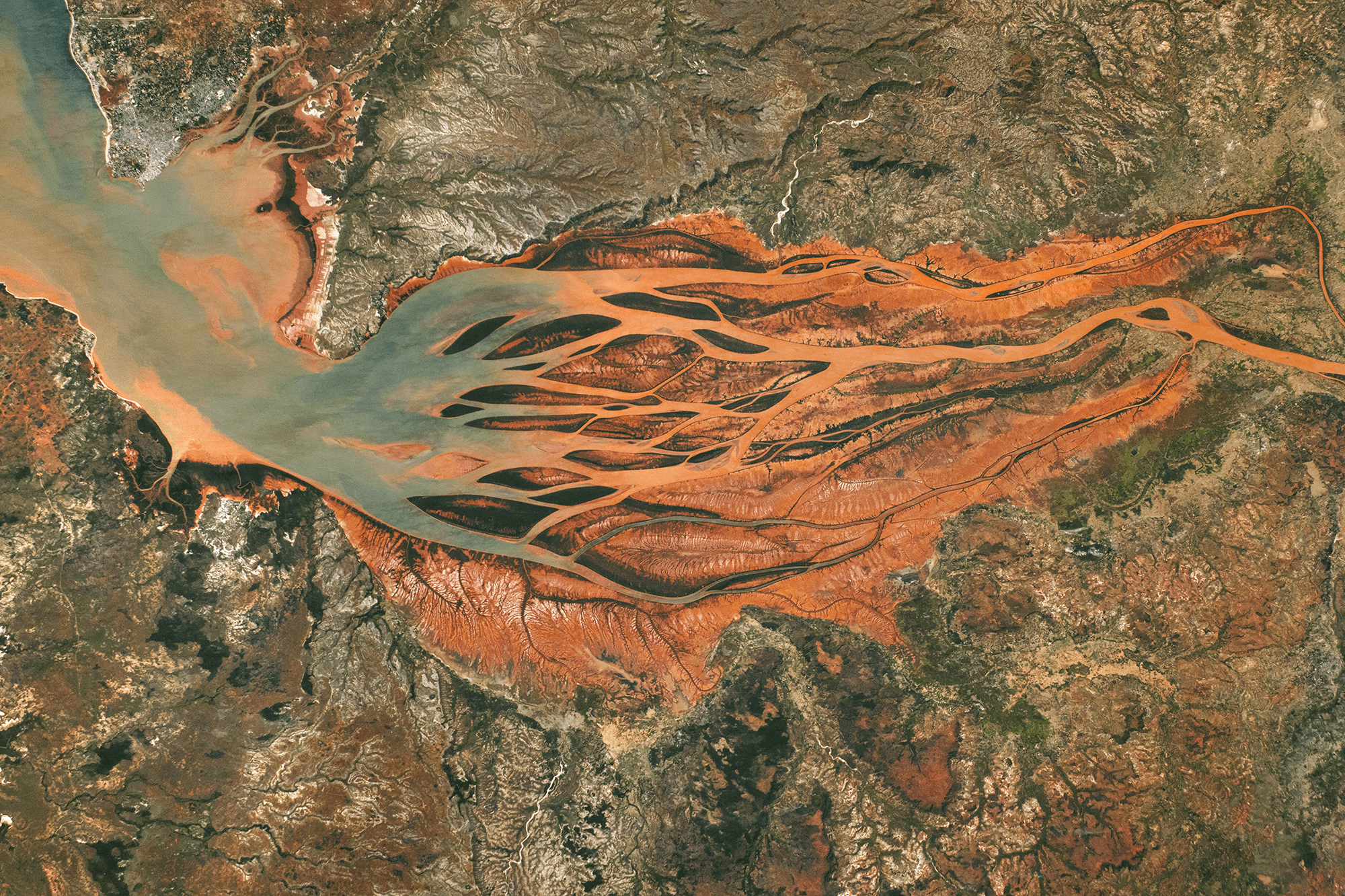
This astronaut photo shows Madagascar’s largest estuary, as of 2024. On the right side, the Betsiboka River flows northwest (right to left, in the image). Less than 100 years ago, most of the estuary was navigable by ships, but now more than half of it is taken up by the river delta. Upstream on the river, extensive logging and expansions to farmland have caused severe soil erosion; the river carries that sediment downstream, dyeing the waters reddish-orange. As the river branches and the flow slows, that sediment falls out of suspension, building up islands and seeding new sand bars further downstream.

A difference of 40 years. A 2024 astronaut photo of the Betsiboka River delta compared with one from 1984 (inset). Several islands are labeled in both images. Notice how new islands have formed upstream of the ones seen in 1984. In the image above, you can compare the 2024 delta to the way it looked in 1984. Letters A, B, C, and D mark the downstream-most islands from 1984. Today newer islands and sand bars sit even further downstream. (Image credit: NASA; via NASA Earth Observatory)

Waves Lap on Titan’s Shores
Titan, one of Saturn’s moons, is the only other planetary body known to have liquid lakes, rivers, and seas at its surface. Whether those bodies — made up of hydrocarbons rather than water, like here on Earth — have waves is a matter of ongoing debate. What data we have from visiting spacecraft is inconclusive. So a group of researchers decided to look for the effects of wave action instead.
Beginning with a model of flooded areas similar to Titan’s, the team simulated a coastline’s erosion assuming three different situations: 1) no coastal erosion, 2) erosion from waves, and 3) uniform erosion through dissolution. Each set of conditions resulted in a very different final coastline. But, of the three, the wave-eroded coast was most similar to those seen on Titan. That’s a good indicator that, even if our spacecraft couldn’t see waves on Titan, they’re likely there. (Image credit: ESA; research credit: R. Palermo et al.; via Gizmodo)
“Serenity”


Peering from directly above, landscapes take on a whole different aspect. That idea is the heart of Vadim Sherbakov’s “Serenity,” filmed by drone. From seething waters and meandering rivers to eroded landscapes and twisting ice, there’s lots of fluid dynamics on display here. (Video and image credit: V. Sherbakov)
Fediverse Reactions
-