Mike Olbinski’s “Vorticity 3” is a stunning view of storm chasing in the American West. I’ve learned after years in Colorado to always look up because dramatic skies are common here, as is seeing rain falling miles away. Olbinski’s film captures all of that grandeur and more, giving all of us a glimpse inside the incredible storms that mark the summer months in this region. You’ll see spinning supercell thunderstorms, bulbous mammatus clouds, towering cumulus clouds, and more. (Video and image credit: M. Olbinski)
Frightening as they can be in the moment, storms have a power and majesty all their own. I’ve never seen a better way to capture that than through timelapse, and photographer Nicolaus Wegner offers a great one in “Stormscapes 4″. I particularly like how his frame captures the motion of storms and how they shear, rotate, and billow as they evolve. With a quick glance upward, it’s easy to miss that motion, even if it is fundamental to these storms. Sit back and enjoy. (Video and image credit: N. Wegner)
Where cold and warm air meet, our atmosphere churns with energy. From the turbulence of supercell thunderclouds to the immense electrical discharge of lightning, there’s much that’s breathtaking about stormy skies. Photographer Dustin Farrell explores them, with a special emphasis on lightning, in his short film, “Transient 2″.
As seen in high-speed video, lightning strikes begin with tree-like leaders that split and spread, searching out the path of least resistance. Once that line from cloud to ground is discovered, electrons flow along a plasma channel that arcs from sky to earth. The estimated temperatures in the core of this plasma reach 50,000 Kelvin, far hotter than the Sun’s surface. It’s this heating that generates the blue-white glow of a lightning bolt. The heating also expands the air nearby explosively, producing the shock wave we hear as a crash of thunder. (Images and video credit: D. Farrell et al.; via Colossal)
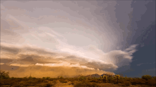
Mike Olbinski’s latest storm chasing timelapse, “Monsoon V,” is once again spectacular. Although I do think the name could have been “Haboob” instead, given how many sweeping dust clouds encroach on the viewer. These towering wall clouds of dust can form from downdrafts at the leading edge of a cold front, or from the fading remains of a thunderstorm. In dry, dusty regions like Arizona, the strong downward winds spread outward as they near the ground, picking up dust and sand. Below you can see two examples of haboobs racing ahead of fronts.
The middle image shows a microburst, where a sudden, localized downdraft falls out of the storm. Notice how the wind and rain sweep outward as they near the ground. This is typical of any flow heading straight toward a wall! Check out the full video for lots more gorgeous fluid dynamics in action. (Video and image credit: M. Olbinski)
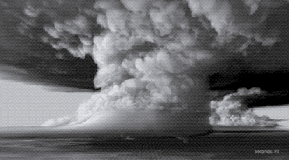
In black and white, the towering power of a thunderstorm looks almost apocalyptic. Photographer Mike Olbinski’s latest storm timelapse, “Breathe,” features roiling turbulence, distant downpours, and eerie mammatus clouds. Supercell thunderstorms churn and rotate over empty horizons. Billowing cumulus clouds condense from bright skies. Flashes of lightning reveal the outlines of massive thunderheads. It’s a beautiful glimpse of atmospheric fluid dynamics in action, with every texture magnified and enhanced by the stark black and white palette. (Video and image credit: M. Olbinski; via Gizmodo)
It’s a cliché to claim that the sky is bigger in the American West, but the wide, open views in that region do offer a very different perspective on weather. Photographer Mike Olbinski’s works give viewers a taste of that perspective of far-off thunderstorms, towering anvil clouds, and massive downpours in the distance. At the same time, many of his sequences illustrate the birth and death of these massive storms. As warm, moist air rises, a puffy cumulus cloud (below) swells upward as fresh moisture condenses. When it reaches a thermal cap and can rise no further, precipitation begins to fall, dragging surrounding air with it. This is the mature stage of a storm, when both updrafts and downdrafts exist simultaneously.
Eventually, the storm’s power begins to wane as the downdrafts cut off the updrafts that feed the storm. Sometimes this occurs in a massive downdraft where cool air sinks straight down and, upon encountering the ground, spreads radially outward. In dry regions, this outward burst of ground-level winds can pick up dirt, dust, and sand, forming a wall-like haboob (below) that advances past the remains of the storm. Watch the entire video to see some examples in their full glory! (Video and image credit: M. Olbinski, source; via Rex W.)
Photographer Mike Olbinski has released yet another breathtaking timelapse film of weather over the Great Plains. This one has a little bit of everything: storms, tornadoes, incrediblecloud formations, and even sunny days. Olbinski’s work is a reminder that there’s a constant beautiful drama playing out over our heads if we just take the time to watch. Under blue skies, condensation and turbulence are building towering mountains, and even when the sky is gray, it can be churning like the ocean just over your head. The U.S. Great Plains may be home to particularly dramatic examples of this behavior (thanks largely to the atmospheric influence of the Rocky Mountains), but these same phenomena are going on all the time overhead. (Video and image credits: M. Olbinski)
With today’s supercomputing power, it’s possible to simulate entire thunderstorms to study how and why some of them can spawn deadly tornadoes. The animation above comes from a computer simulation of a supercell thunderstorm. The simulation uses initial conditions from a 2011 storm that produced an EF-5 tornado – the highest category of tornado, based on its wind speeds. To see more of the simulation, check out the video below. One thing that might surprise you is just how enormous the towering supercell clouds are compared to the tornado produced in the simulation. Often what we can see of a storm from the ground is only the tiniest part of what goes into producing it. (Image credit: L. Orf et al., source; GIF via @popsci; video credit: UWSSEC)
Photographer Mike Olbinski returns with another incredible storm-chasing timelapse video, this time all in black-and-white. To me, that choice helps “Pulse” emphasize the ominous majesty of these supercells and tornadoes by highlighting the textures that make up the clouds. Watching clouds in timelapse, they seem to materialize from nowhere as moisture drawn up from the land cools and condenses. Sped up, suddenly the convective rotation and the roiling turbulence inside clouds is perfectly clear. I especially love the sequence beginning at 2:25, where a distant black line slowly transforms into an incredible landscape marked with successive waves of rolling, turbulent clouds. Watch this one on a large screen at a high resolution, if you can. You won’t regret it! (Video credit: M. Olbinski)
Earlier this week a Columbus, OH TV station tower camera caught this awesome timelapse footage of several microbursts in a thunderstorm. A microburst is a sudden, localized downdraft inside the storm. You can see a clear microburst starting at about 0:30 seconds. Note how it flares up and out as it hits the ground, eventually settling around the time a rainbow appears on the left edge of the frame. These strong winds moving down then curling out can be dangerous, both to structures on the ground and to any aircraft unfortunate enough to be taking off or landing in the storm. (Video credit: WCMH; submitted by
A. Bcstractor)