Photographer Mike Olbinski is back with another storm-chasing timelapse entitled “Vorticity”. Like his previous work, this film is a breath-taking example of physics in action. It is well worth taking a few minutes to watch in fullscreen, at high resolution, and with headphones. Olbinski’s timelapses beautifully capture the incredible dynamic motion of our atmosphere. Fittingly, “Vorticity” is all about the swirling, roiling motion of supercell thunderstorms and the tornadoes they can spawn, but the film also captures many other great phenomena from the convection that builds clouds to unusual formations like undulatus asperatus and mammatus clouds. (Video credit: M. Olbinski; submitted by Paul vdB)
Tag: thunderstorm

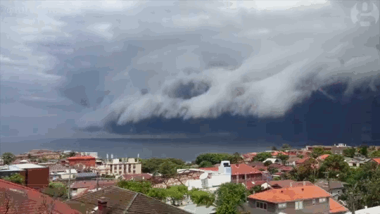
Shelf Cloud
Sydney, Australia was treated to a spectacular meteorological show over the weekend when an impressive shelf cloud swept over the city. These timelapses show the dramatic leading edge of the incoming thunderstorm. Notice how the cloud streams upward along the shelf. The storm is driven by this updraft of warm moist air, which rises until it is capped by the troposphere. At this point, the air spreads, creating an anvil-like shape, and cools. The moisture drawn up at the storm’s front will condense, freeze, and fall as rain or hail. When the updraft weakens, the storm will be dominated by the downdraft of the falling precipitation and eventually peter out. (Image credit: W. Reed and H. Vann, source; via J. Hertzberg)

“The Chase”
Sometimes it takes timelapse photography to truly appreciate the dynamic behavior of our atmosphere. In “The Chase” Mike Olbinski, whose work we’ve featured previously, has captured some of the most incredible and stunning weather timelapse footage I have ever seen. Despite watching it repeatedly, I continue to be awed to the point that I have no words. Seriously, just watch it. Be amazed by the drama of our sky. (Video credit: M. Olbinski)
Supercell Timelapse
The storm chasing group Basehunters captured this stunning timelapse of a supercell thunderstorm forming in Wyoming. This class of storm is characterized by the presence of a mesocyclone, seen here as a large, rotating cloud. These rotating features form when horizontal wind shear is redirected upright by an updraft. This requires a strong updraft, which is often formed by a capping inversion, where a layer of warm air traps colder air beneath it. Supercells can be very dangerous in their own right, releasing torrential rains and large hail, but they are also capable of spawning violent tornadoes. (Video credit: Basehunters; via Bad Astronomy; submitted by jshoer)
Supercell Thunderstorm
Photographer Mike Olbinski has captured a spectacular timelapse of a supercell thunderstorm over the plains of Texas. Supercells are characterized by a strong, rotating updraft known as a mesocyclone, seen clearly in the video. These storms are commonly isolated occurrences, forming when horizontal vorticity in the form of wind shear is redirected upwards by an updraft. Such a strong updraft is typically created by a capping inversion, a situation where a layer of warmer air traps the colder air beneath it. (This is why one sees a distinctive cut-off at the top of some clouds.) As warm air rises from the surface, either the air above the cap will cool or the air below the cap will warm. Either situation results in an instability with cooler air on top of warmer air, providing a catalyst for the kind of dramatic weather seen here. (Video credit: M. Olbinski; via io9)