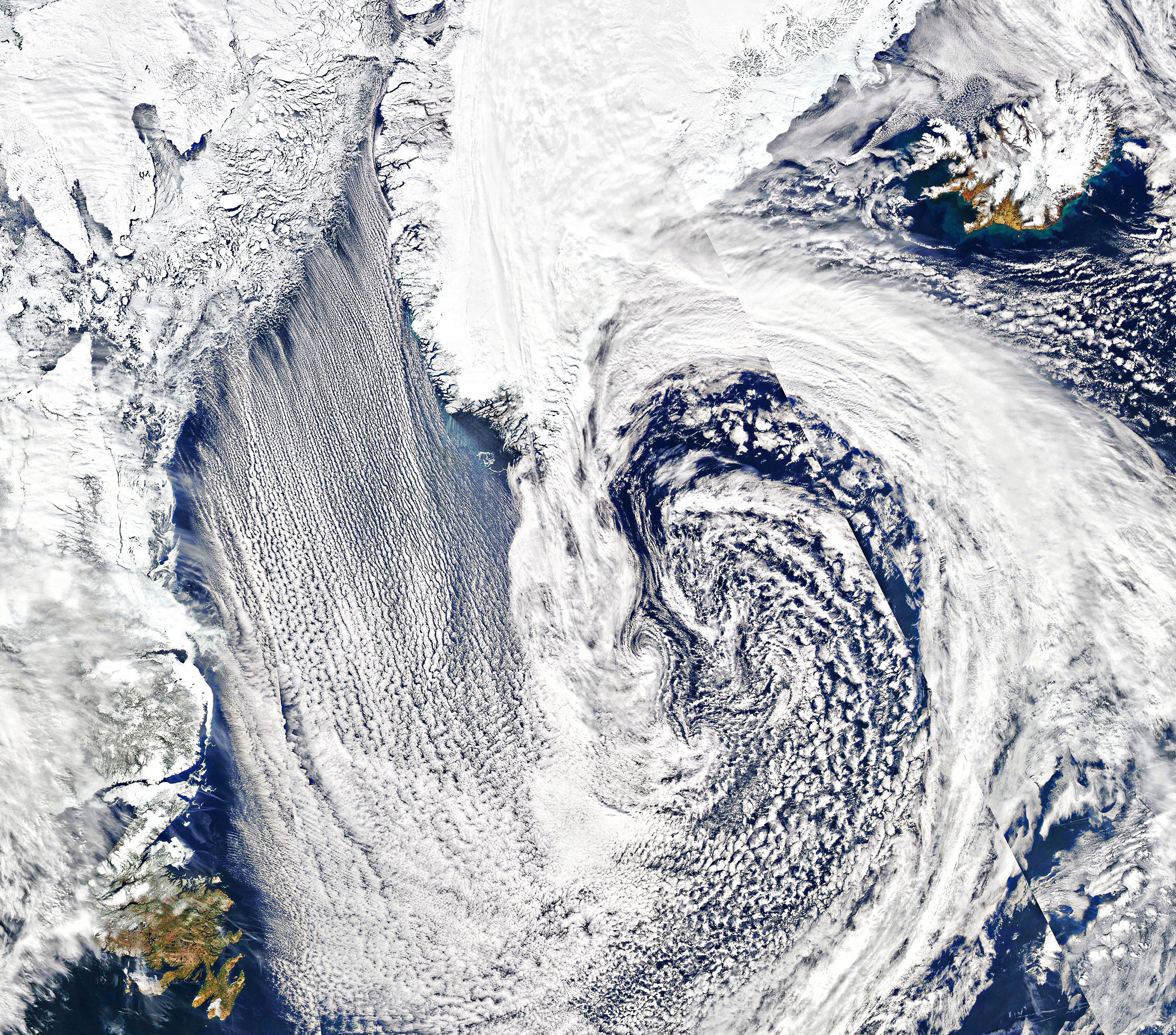
Parallel lines of cumulus clouds stream over the Labrador Sea in this satellite image. These cloud streets are formed when cold, dry winds blow across comparatively warm waters. As the air warms and moistens over the open water, it rises until it hits a temperature inversion, which forces it to roll to the side, forming parallel cylinders of rotating air. On the rising side of the cylinder, clouds form while skies remain clear where the air is sinking. The result are these long, parallel cloud bands. (Image credit: J. Stevens; via NASA Earth Observatory)
Tag: meteorology

Making Hurricanes


With oceans warming, there’s more energy available to intensify hurricanes. And while our weather models have gotten better at predicting where hurricanes will go, they’re less good at predicting hurricane intensity, largely because capturing real data from storms is so difficult and dangerous. To address that shortfall, engineers build facilities like the one seen here, which simulates hurricane wind and water conditions so that scientists can study their interaction and better understand storm physics. Check out the full Be Smart video for a tour of the facility and a look at their work. (Image and video credit: Be Smart)

Asperitas Formation
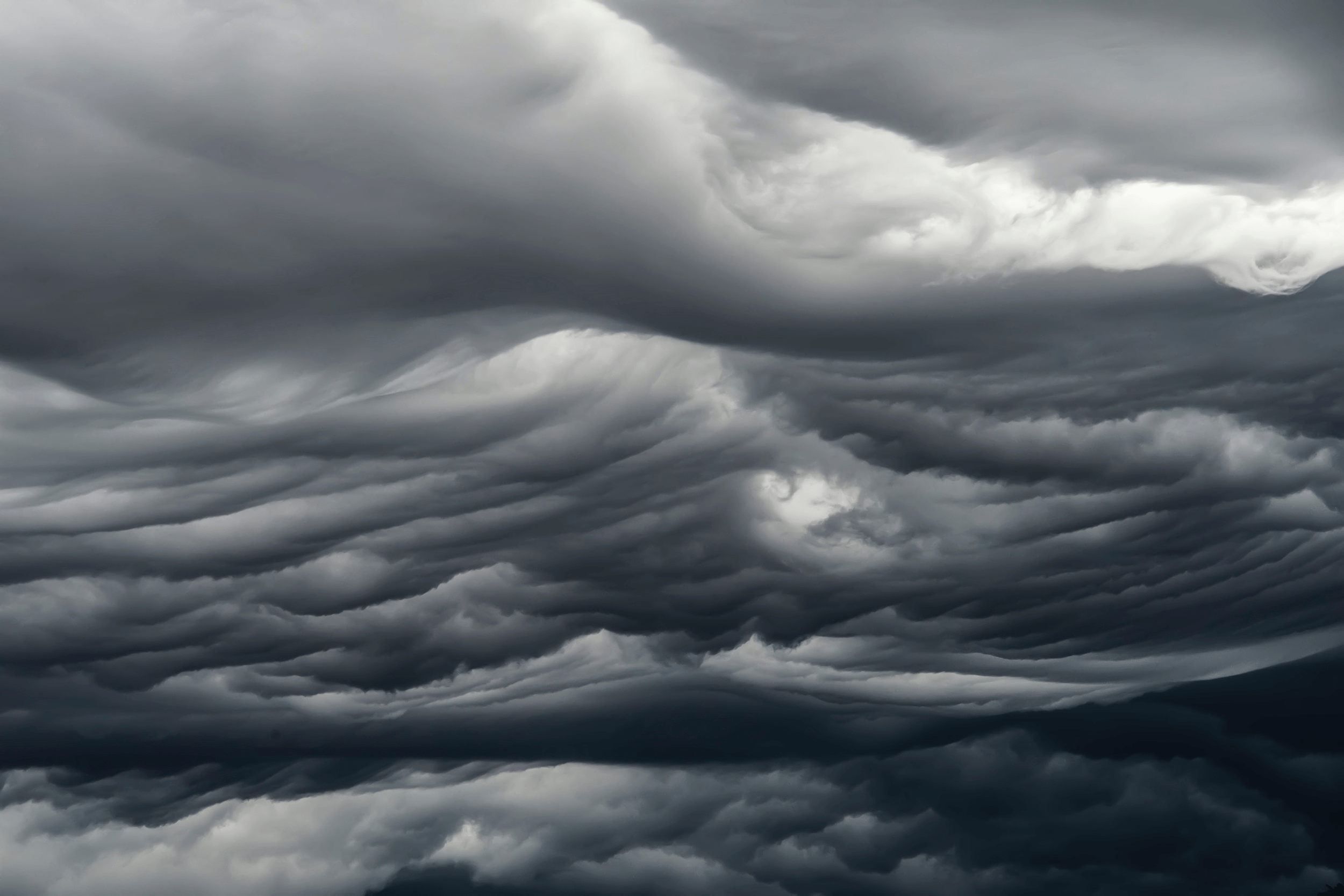
In 2017, the World Meteorological Organization named a new cloud type: the wave-like asperitas cloud. How these rare and distinctive clouds form is still a matter of debate, but this new study suggests that they need conditions similar to those that produce mammatus clouds, plus some added shear.
Using direct numerical simulations, the authors studied a moisture-filled cloud layer sitting above drier ambient air. Without shear, large droplets in this cloud layer slowly settle downward. As the droplets evaporate, they cool the area just below the cloud, changing the density and creating a Rayleigh-Taylor-like instability. This is one proposed mechanism for mammatus clouds, which have bulbous shapes that sink down from the cloud.
When they added shear to the simulation, the authors found that instead of mammatus clouds, they observed asperitas ones. But the amount of shear had to be just right. Too little shear produced mammatus clouds; too much and the shear smeared out the sinking lobes before they could form asperitas waves. (Image credit: A. Beatson; research credit: S. Ravichandran and R. Govindarajan)
“Haboob: A Decade of Dust”


From the right vantage point, an approaching dust storm — known as a haboob — can look downright apocalyptic. In this compilation of clips a decade in the making, photographer Mike Olbinski shows these storms in all their terrifying majesty. I love seeing how the cloud front overhead densifies as the dust below advances. Without these wide perspectives, it’s hard to appreciate an approaching haboob. When one blew through Denver a few years ago, I never saw it coming. My first clue was the tree in front of my office window whipping wildly back and forth just before the sky turned brown! I much prefer Olbinski’s versions. Congratulations, Mike, on a decade of haboob-chasing! (Image and video credit: M. Olbinski; submitted by jpshoer)

Stormy Skies


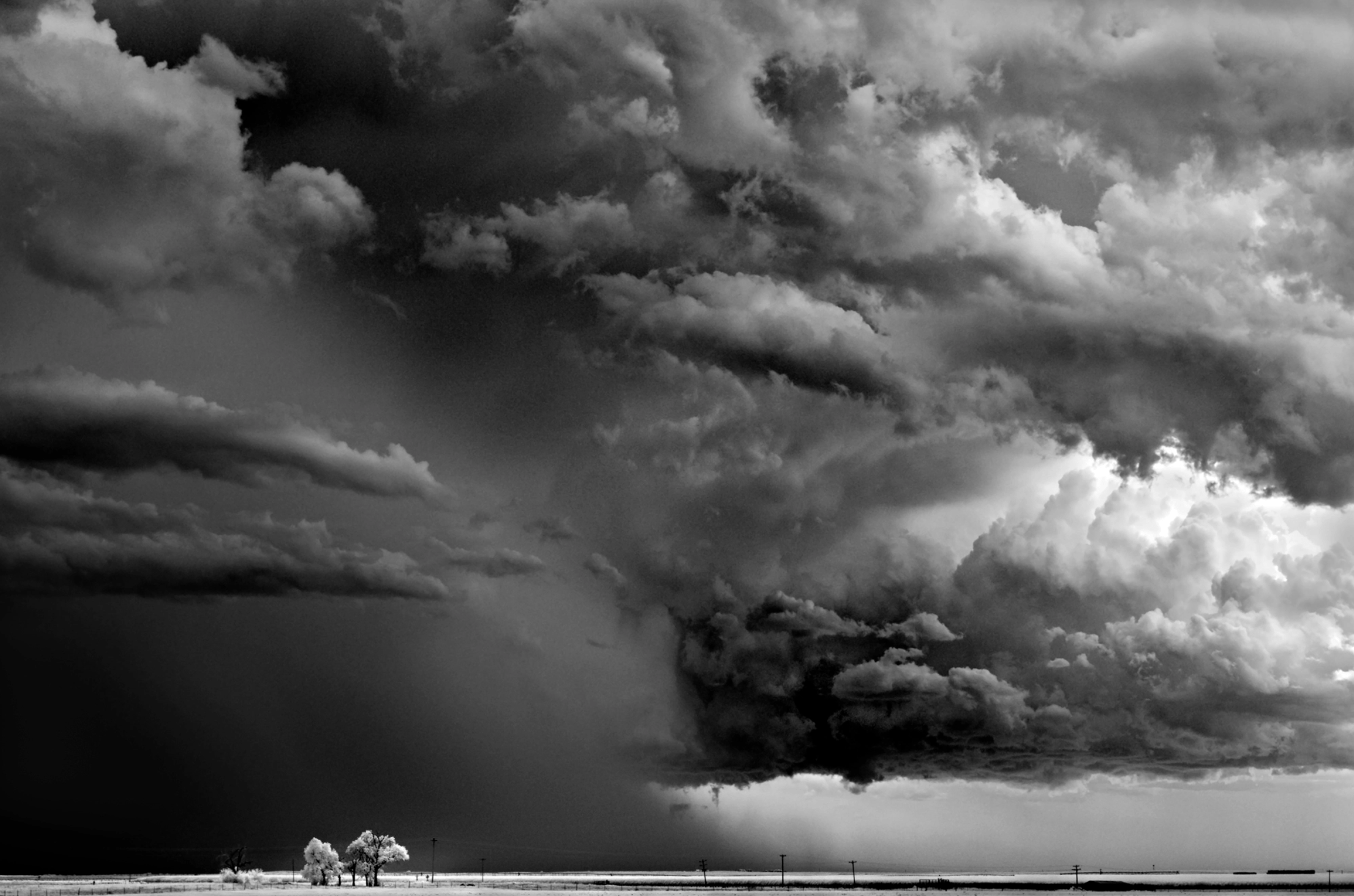


Photographer Mitch Dobrowner captures the majestic and terrifying power of storms in his black and white images. Towering turbulence, swirling vortices, and convective clouds abound. See more of his work at his website and Instagram. (Image credit: M. Dobrowner; via Colossal)
“Reverent”


Today, enjoy this moody black-and-white short film of storm timelapses. Photographer Mike Olbinski is a master of this subject. I never tire of watching his towering convective supercell thunderstorms or his picturesque microbursts. The lightning-lit clouds in the latter half of the film are particularly spectacular (assuming you do not have sensitivities to flashing lights). And there are a few haboobs and a tornado in there for good measure, too. (Image and video credit: M. Olbinski)

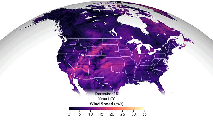
December’s Derecho
I confess I’d never heard the term derecho before moving to Colorado, but I’ve experienced a few of these wind storms now. They’re intense! Last December’s derecho formed when a high-pressure system in the western United States met a strong low-pressure system over the northern plains. In fluids, flow moves preferentially from areas of high pressure to those with low pressure, and that’s no different when it comes to weather. The strong pressure gradient drove high winds from the Rocky Mountains to Minnesota. The animation above shows the strongest winds in in yellow-white but even the “weaker” pink areas saw winds comparable to a fast-moving car in speed. The visualization is constructed from data reported by ships, buoys, aircraft, satellites, and other sources, all processed through a NASA weather algorithm. (Image credit: J. Stevens/NASA; via NASA Earth Observatory)
“Shadows in the Sky”


This moody music video features storm chasing footage from photographer Mike Olbinski. As always, his captures are stunningly majestic. Watch closely and you’ll see everything from bulbous mammatus clouds to powerful microbursts, from horizon-obscuring haboobs to sky-splitting lightning. And if this video isn’t enough, there’s plenty more to enjoy. (Video and image credit: M. Olbinski)

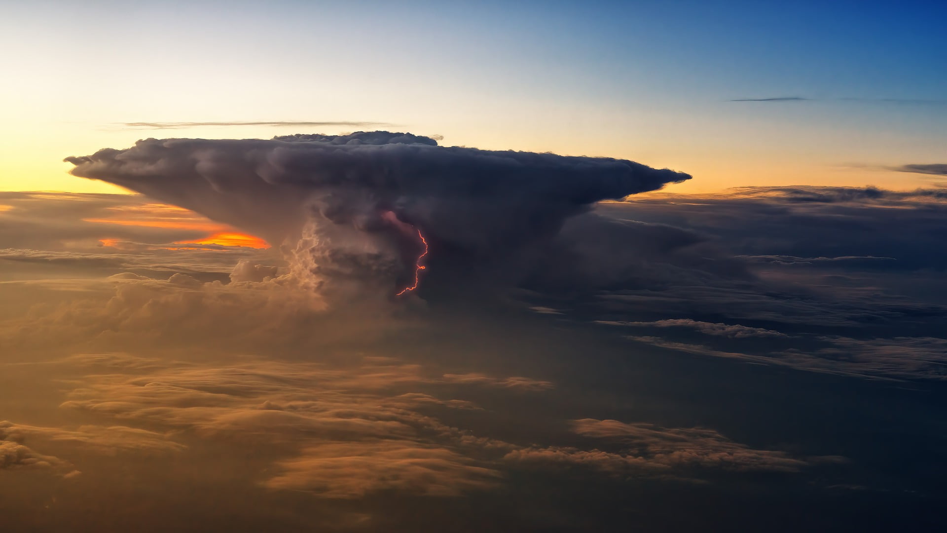
Mountains in the Sky
Our skies can sometimes presage the weather to come. In thunderstorms, a cirrus plume above an anvil cloud will often appear (visible by satellite) about half an hour before severe conditions are reported on the ground. A new study delves into the origins of these plumes and finds that they result from an internal hydraulic jump in the storm that acts a bit like an artificial mountain, driving air — and the moisture it contains — higher in the stratosphere than normal. Once the jump is established, the authors found it could drive 7 tonnes per second of water vapor into the stratosphere! (Image credit: jplenio; research credit: M. O’Neill et al.; via Science)

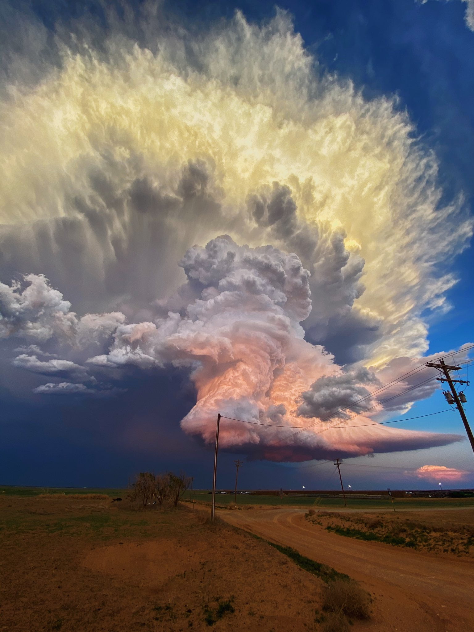
Candy Clouds Mid-Storm
There’s nothing quite like a towering storm cloud to showcase nature’s power. This gorgeous photo by Laura Rowe shows pastel clouds over West Texas in the middle of a thunderstorm. Despite the dusk at ground level, the height of the cloud keeps it lit by direct sunlight, giving its turbulent convection that colorful glow. Rowe, as it happens, is not a professional photographer, which is a good reminder to us all: it’s always worth looking up! You never know what beauty you’ll miss if you don’t. (Image credit: L. Rowe; via Colossal)