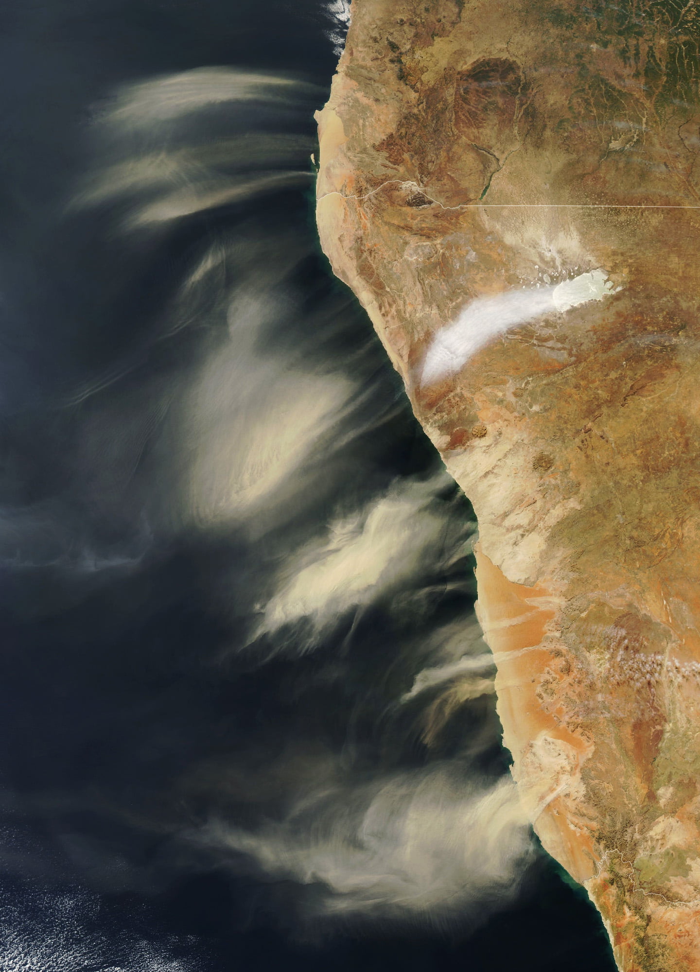
Hot, dry berg winds swept down from the Namibian highlands and sent these plumes of dust flying out to the Atlantic coast. Another plume — white instead of brown — marks salt dust from the Etosha Pan salt flat. The dust and salt become aerosol particles in the atmosphere — seeds for raindrops to form. Coastal towns sometimes need construction equipment to deal with the drifting sand from these storms, but these storms are small compared to Saharan dust storms. Those storms are so large that their dust influences the weather on the other side of the Atlantic. (Image credit: W. Liang; via NASA Earth Observatory)
Tag: meteorology

Rolling Over Wisconsin
Although they may look sinister, roll clouds like this one are no tornado. These unusual clouds form near advancing cold fronts when downdrafts cause warm, moist air to rise, cool below the dew point, and condense into a cloud. Air in the cloud can circulate around its long horizontal axis, but the clouds won’t transform into a tornado. Roll clouds are also known as Morning Glory clouds because they often form early in the day along the Queensland coast, where springtime breezes off the water promote their growth. The clouds do form elsewhere, though; this example is from Wisconsin in 2007. (Image credit: M. Hanrahan; via APOD)

Clouds Down Under
This large and unusual cloud formation was captured one July morning over western Australia. Stretching over 1,000 kilometers, the clouds have interesting features at both the large and small scale. The small-scale ripples within the clouds are gravity waves triggered by the terrain below. The larger, arced features are tougher to explain, though they may also be related to gravity waves and terrain, just on a much larger scale. They also resemble fallstreak clouds where supercooled droplets evaporate from the inside of the cloud out. (Image credit: W. Liang; via NASA Earth Observatory)

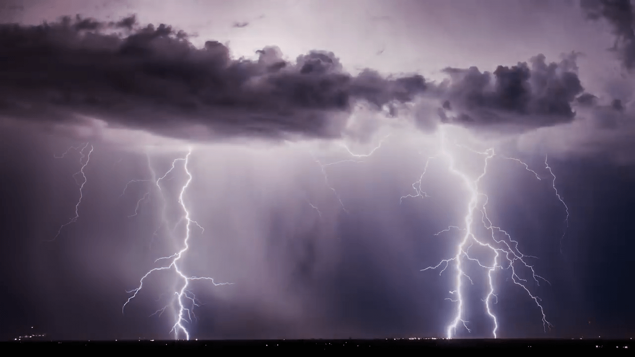
“Vorticity 5”


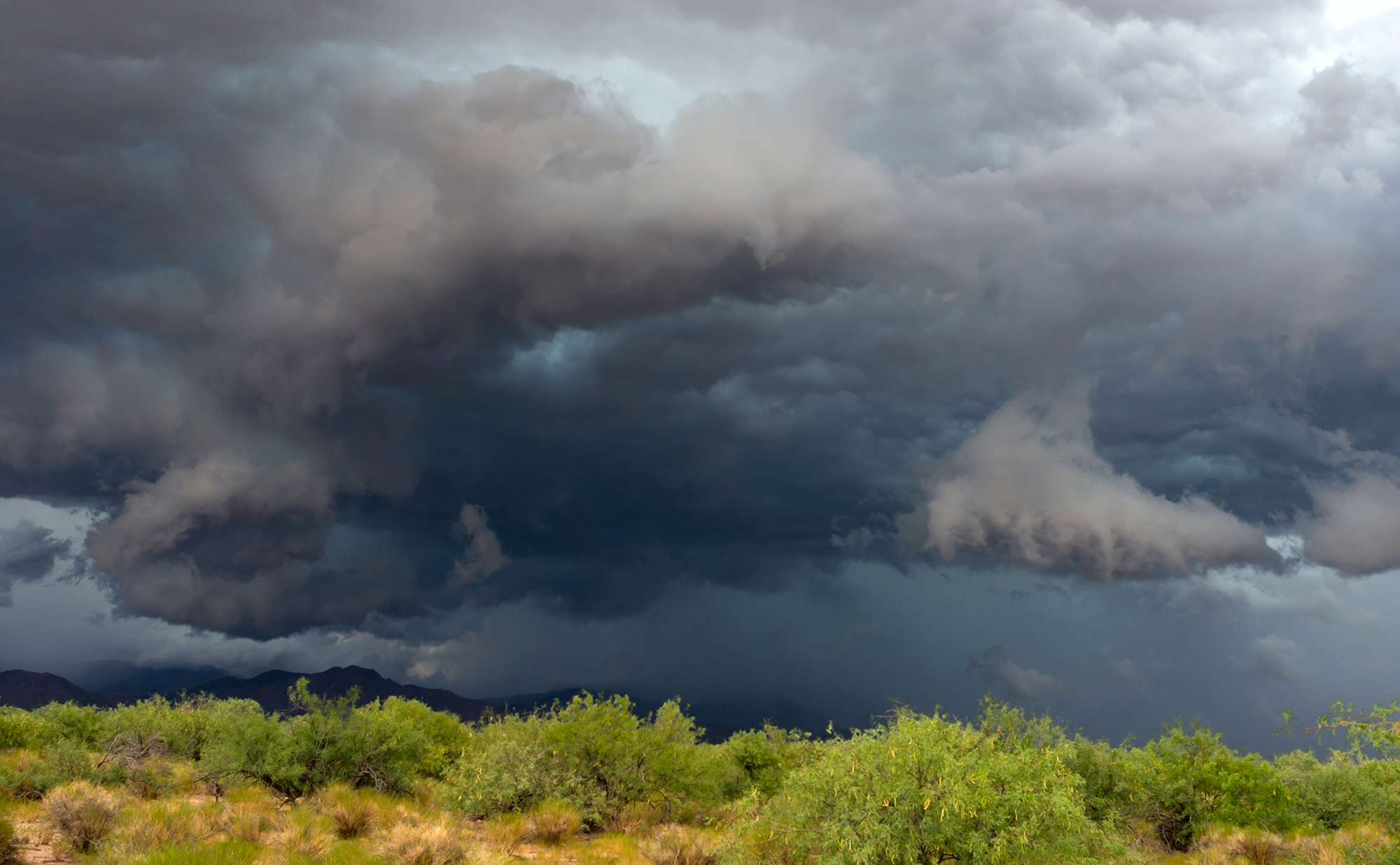
Photographer and stormchaser extraordinaire Mike Olbinski is back with the fifth volume in his “Vorticity” series. Shot over the 2022 and 2023 tornado seasons in the U.S. Central Plains, this edition has virtually everything: supercells, microbursts, lightning, tornadoes, and haboobs. There’s towering convection and churning, swirling turbulence. It’s a spectacular look at the power and grandeur of our atmosphere. (Video and image credit: M. Olbinski)

How Squall Lines Form
Summertime in the middle U.S. means thunderstorms, many of which can form long lines of storms known as squall lines. Complex convective dynamics feed such storms. Here is an illustration of one part of a squall’s lifecycle:

As rain falls and evaporates, it fuels the formation of a cold pool of air below the cloud. Incoming wind (gray arrows) blocks the cold pool from spreading. In turn, the cold pool acts as a ramp that redirects this warm, moist air upward. The vertical variation in wind speed (wind shear, shown with pink arrows) creates a positive vorticity. Together with the negative vorticity in the cold pool, this induces a vorticity dipole that lifts air and moisture, feeding the growing line of storms. As it falls, rain evaporates, cooling air near the ground and forming a cold pool. If incoming winds block the cold pool from spreading, the pool will act instead as a ramp that redirects the wind upward, carrying any warmth and moisture up into the storm cloud. Wind shear — a vertical variation in wind strength with altitude — creates positve vorticity that opposes the negative vorticity inherent to the cold pool. Together these two regions of opposing vorticity lift more air and moisture into the squall, generating more clouds and more rainfall. (Image credit: top – J. Witkowski, illustration – C. Muller and S. Abramian; see also C. Muller and S. Abramian)
“Níłtsą́”


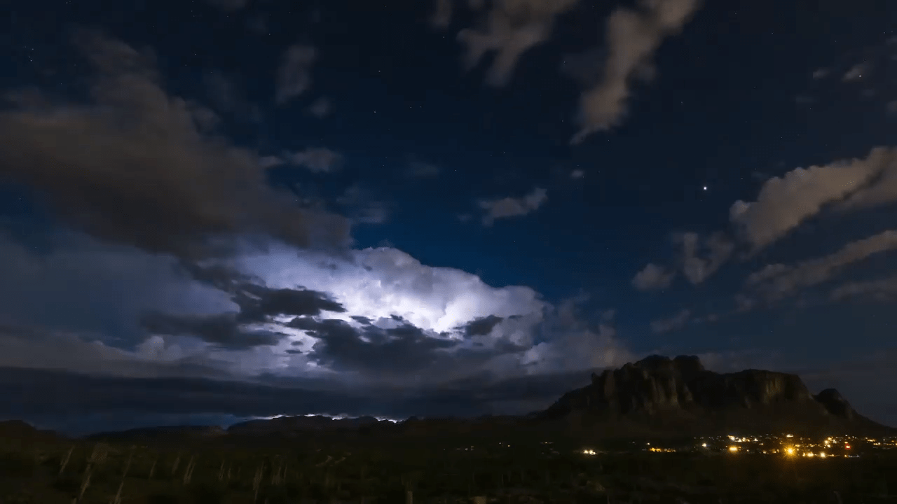
Living in the central and western United States, it’s easy to dismiss summer weather as just another storm, but the truth is that this region sees some of the most majestic and spectacular thunderstorms in the world. And no one captures that grandeur better than storm-chasing photographer Mike Olbinski. His latest film is named for the Navajo word for rain and features over 12 minutes of the best storms from 2021 and 2022. Towering turbulent clouds grow by convection, lightning splits the night sky, and microbursts pour down from above. As always, it’s a stunning depiction of the power of atmospheric fluid dynamics. (Image and video credit: M. Olbinski)
Predicting Heat Waves
The United States, Europe, and Russia have all seen deadly, record-breaking heat waves in recent years, largely in areas that are ill-equipped for sustained high temperatures. A new paper presents a theory that predicts how hot these heat waves can get and what mechanism ultimately breaks the hot streak.
Heat waves start when an area of high-pressure air forms over land, with an anticyclone circulating around it. Air at the center of the zone warms and rises, and if the anticylone can’t move, temperatures will just keep rising. Despite the heat, there is still moisture in the rising air of a heat wave. The authors found that if that moist air can reach an altitude where the atmospheric pressure is 500 hPa (a typical altitude of 5-7 km), then the maximum daily temperature will stop rising. At that altitude, the moist air can condense into rain, and, even if that rain evaporates before reaching the ground, it is enough to cool temperatures.
The key variable in the theory is the atmospheric temperature at 500 hPa, something that meteorological models are able to predict well up to three weeks in advance. That means this theory should enable meteorologists to give advanced warning of high temperatures, helping communities prepare. (Image credit: T. Baginski; research credit: Y. Zhang and W. Boos; via APS Physics)

Ominous Mammatus
Mammatus clouds are fairly unusual and often look quite dramatic. Most clouds have flat bottoms, caused by the specific height and temperature at which their droplets condense. But mammatus clouds have bubble-like bottoms that are thought to form when large droplets of water or ice sink as they evaporate. Although they can occur in the turbulence caused by a thunderstorm, mammatus clouds themselves are not a storm cloud. They appear in non-stormy skies, too. The clouds are particularly striking when they’re lit from the side, as in the image above. (Image credit: J. Olson; via APOD)

Nacreous Clouds
Iridescent clouds shine bright over this Finnish sunset. These colorful clouds are nacreous clouds, also known as mother-of-pearl clouds. Formed from ice crystals during frigid conditions in the lower stratosphere, these clouds are most visible before dawn and after sunset, when their high altitude catches sunlight while the lower atmosphere doesn’t. These rare clouds form mostly in high latitudes during winter. While they appear similar to other iridescent clouds that occur all over the world, nacreous clouds are far brighter and more vivid. (Image credit: D. Lehtonen; via APOD)

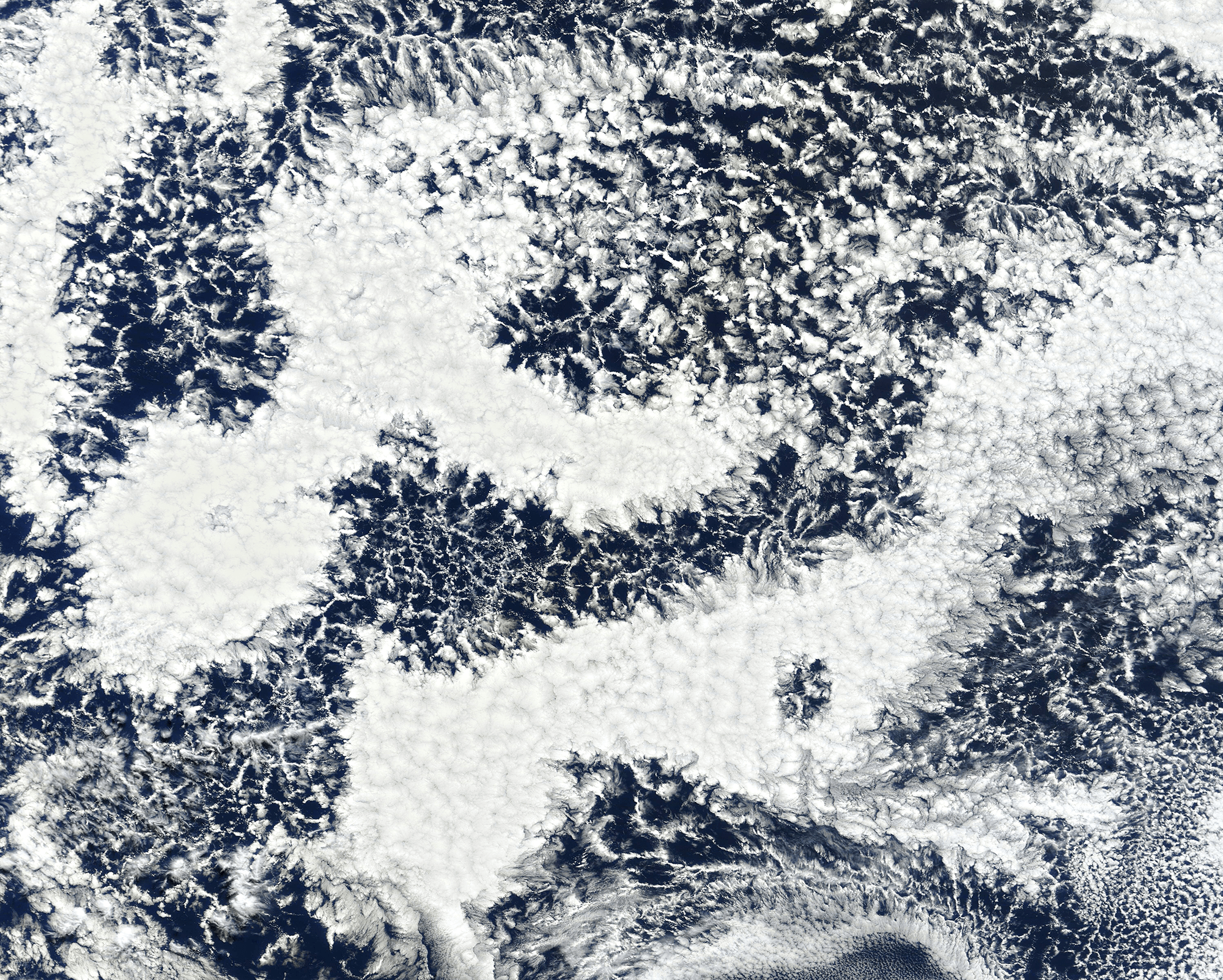
Cellular Clouds
Though tough to make out from the surface, our oceans are often covered by cell-shaped clouds stretching thousands of kilometers. This satellite image shows off two such types of marine stratocumulus cloud. Open-celled clouds appear as thin wisps of vapor around an empty middle; in these clouds, cool air sinks through the center while warm air rises along the edges. Open-celled clouds are good rain producers.
On the flip side, closed-cell clouds have a vapor-filled center and breaks in the cloud cover along each cell’s edge. These clouds don’t produce much rain, but they do lift warm, moist air through their middles and let cool air sink along their edges. Closed-cell clouds tend to last much longer than their open-celled counterparts; they can stick around for half a day, whereas open-celled clouds break up in only a couple hours. (Image credit: J. Stevens; via NASA Earth Observatory)