Tag: erosion

  • Eroding Grains

    Eroding Grains

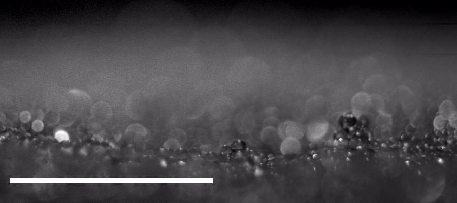
    When a spacecraft comes in for a landing (or a tag similar to what OSIRIS-REx did), there’s a turbulent jet that points straight into a bed of particles. How those particles react — how they erode and the crater that forms — depends on many factors, including the cohesion between particles. In these experiments, researchers investigated such a jet (in air) and its impact on particles with differing amounts of cohesion.

    When there is little cohesion between particles, erosion takes place a single particle at a time (Image 1). Once there’s some cohesion, the jet’s velocity has to be higher to trigger erosion (Image 2). Once erosion does begin, it includes both singular and clumped particles. In highly cohesive beds, velocities must be even higher to create erosion, which takes place with large clusters of particles flying off together (Image 3). (Image and research credit: R. Sharma et al.)

  • Frozen Wind-Sculpted Sands

    Frozen Wind-Sculpted Sands

    On the cold, wind-swept beaches of Lake Michigan, the sands sometimes turn into a landscape of miniature hoodoos. Strong winds erode the frozen sand into these shapes, which last only days before wearing away or falling over. This photographic series by Joshua Nowicki immortalizes the ephemeral winter sculptures. You can see more of his photography on his Instagram. (Image credit: J. Nowicki; via Colossal; see also)

  • “Ruin of the Tides”

    “Ruin of the Tides”

    As tides and waves flow back and forth over a beach, they erode the sandy shore. Here photographer Michael Shainblum captures the streaks and rivulets left by a falling tide. These “ruins” resemble an extensive river delta viewed from above. I love the complicated branches carved by the water’s retreat. (Image credit: M. Shainblum)

  • Featured Video Play Icon

    How Sinkholes Form

    Growing up in the Ozarks, I explored my fair share of caves and sinkholes. These geological features form when flowing groundwater erodes soil, sand, and even rock underground. The Ozark Plateau consists largely of limestone, which is water soluble, making it very prone to this internal erosion. As bedrock dissolves away, it is eventually unable to hold up the weight of ground above it, causing a catastrophic collapse into a sinkhole. Although my childhood sinkholes were naturally occurring, they can also form in spots where leaking pipes and infrastructure help wash underlying soil away. Unfortunately for engineers, this internal erosion can take place for years without any visible sign above ground. (Image and video credit: Practical Engineering)

  • Martian Polar Troughs

    Martian Polar Troughs

    Mars‘s northern pole is capped by a spiral-like pattern of deep troughs that are covered by carbon dioxide ice in winter but visible from orbit in summer. A new study posits that the spiral formed by wind erosion, exposing layer after layer of Martian geology.

    The center of Mars’s polar cap is higher in the center than toward the edges, so katabatic winds — cold, dense flows beginning at high elevation — rush down from the pole. But because Mars spins, the Coriolis force causes those winds to flow in an anti-clockwise spiral. As those winds encounter depressions perpendicular to their path, they generate vortices that erode the depression. Eventually, a depression deepens, merges with other depressions, and forms a trough. According to this theory, the clockwise spiral of the troughs is a direct result of the katabatic winds flowing across them. Head over to Bad Astronomy or check out the original paper for more. (Image credit: ESA/DLR/FU Berlin/J. Cowart; research credit: J. Rodriguez et al.; via Bad Astronomy; submitted by Kam-Yung Soh)

  • A Macro View of Weathering

    A Macro View of Weathering

    Water constantly weathers sedimentary rock, both physically — through abrasion — and chemically — through dissolution and recrystallization. Now researchers have gotten their first view of this weathering at the Ångstrom level by observing porous rocks with environmental transmission electron microscopy as they interact with both water vapor and liquid water.

    As expected, the experiments with liquid water showed that water dissolved the rocks and substantially changed the geometry of the rock’s pores. But the experiments also showed significant weathering from water vapor alone. The researchers found that water vapor formed a film on the surface of the rock’s pores in a process known as adsorption. This film substantially decreased the size of each pore and created strain in the rock. Once the water vapor was removed, the rock’s pores were notably altered, supporting the idea that this adsorption was, itself, a form of weathering. (Image credit: M. Kosloski; research credit: E. Barsotti et al.; via AGU EOS; submitted by Kam-Yung Soh)

  • Featured Video Play Icon

    Coastal Erosion

    The same dynamic forces that make coastlines fascinating create perennial headaches for engineers trying to maintain coastlines against erosion. This Practical Engineering video discusses some of the challenges of coastal erosion and how engineers counter them.

    In a completely undeveloped coastline, waves and storms erode the shoreline while rivers and currents replenish sand through sedimentation. Manmade structures tend to strengthen erosion processes while disrupting the sedimentation that would normally counter it. Beach nourishment — where sand gets dredged up and deposited on a beach — is an engineered attempt to replace natural sedimentation.

    Dunes, mangrove forests, and wetlands are all nature’s way of protecting and maintaining coastlines. We engineers are still learning how to both utilize and protect shorelines. (Image and video credit: Practical Engineering)

  • Uncovering Erosion Patterns

    Uncovering Erosion Patterns

    Gypsum and limestone cliffs sometimes form patterns of long, parallel grooves known as rillenkarren. Recent research shows that these patterns form when a thin layer of water flows over a dissolvable surface. As the running water picks up solute, its concentration increases, causing changes in the local hydrodynamics. What begins as a small perturbation in an otherwise flat surface grows into a groove with walls that eventually rise out of the water layer. At that point, the growth mechanism shifts because the flow is restricted to channels in the rock. (Image credit: Ymaup/Wikimedia Commons; research credit: A. Guérin et al.; via APS Physics; submitted by Kam-Yung Soh)

  • Dissolving Caramel

    Dissolving Caramel

    In nature, erosion patterns are driven by the interactions of flow and topography. Here, researchers study that process in the lab by placing an inclined block of caramel in quiescent syrup and watching as it dissolves. Initially, the bottom surface of the block develops regularly-spaced plumes — the dark lines seen in the first image. But because the caramel-laden plumes are heavier than the surrounding fluid, the flow quickly becomes unstable. The plumes cross one another and begin to carve chevrons into the caramel.

    The chevrons appear to march their way upward in the video. They slowly grow and change into a distinctly scalloped pattern. Scallops like these are often seen by geologists in caves and icebergs, and the authors argue that their results and modeling indicate the importance of buoyant flow effects on such natural formations. (Image and research credit: C. Cohen et al.)

  • Colorful Tides

    Colorful Tides

    This false-color satellite image — the recent winner of NASA Earth Observatory’s Tournament Earth 2020 — shows sands and seaweed off the coast of the Bahamas. Ocean currents and tides eroded these elaborate fluted designs in much the same way that winds sculpt desert dunes. The overlap in form is no accident; as seen in recent work, researchers are finding that both air and water move granular materials like sand according to the same rules. (Image credit: S. Andrefouet; via NASA Earth Observatory)