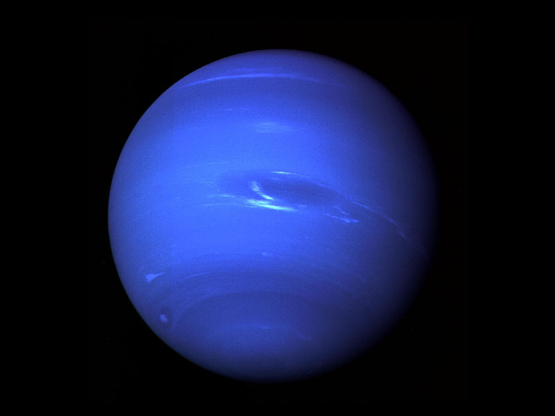
Ice giant Neptune orbits our sun once every 165 years, meaning that each season on the planet lasts about 41 years here on Earth. Currently, the side of Neptune facing us is entering early summer, but a recent survey of atmospheric measurements show that Neptune’s stratosphere is experiencing some unexpected changes. Between 2003 and 2018, the team found that global stratospheric temperatures actually decreased by 8 degrees Celsius. Even more dramatically, Neptune’s southern pole warmed by a full 11 degrees Celsius between 2018 and 2020. Both results hint that atmospheric patterns on the planet may be far more complex than current models assume. (Image credit: NASA/JPL; research credit: M. Roman et al.; via Physics World)
Tag: atmospheric science

Making Hurricanes


With oceans warming, there’s more energy available to intensify hurricanes. And while our weather models have gotten better at predicting where hurricanes will go, they’re less good at predicting hurricane intensity, largely because capturing real data from storms is so difficult and dangerous. To address that shortfall, engineers build facilities like the one seen here, which simulates hurricane wind and water conditions so that scientists can study their interaction and better understand storm physics. Check out the full Be Smart video for a tour of the facility and a look at their work. (Image and video credit: Be Smart)

Deciphering Krakatau
In 1883, the eruption of Krakatau (also called Krakatoa) shook the world, sending shock waves and tsunamis ricocheting across the globe. Some of the smaller waves hit shorelines in the Atlantic and Pacific that were entire continents and ocean basins away from the original explosion. At the time, scientists were so perplexed by the phenomenon that they blamed coincidental earthquakes for the wave action.
Only when Tonga experienced a similarly devastating volcanic eruption earlier this year were scientists able to verify what they’d long suspected: these smaller tsunamis were not caused by solid material displacing water; instead they are the result of atmospheric pressure waves coupling to the ocean. Follow the full story over at Quanta. (Image credit: M. Barlow; via Quanta; submitted by Kam-Yung Soh)
“Shadows in the Sky”


This moody music video features storm chasing footage from photographer Mike Olbinski. As always, his captures are stunningly majestic. Watch closely and you’ll see everything from bulbous mammatus clouds to powerful microbursts, from horizon-obscuring haboobs to sky-splitting lightning. And if this video isn’t enough, there’s plenty more to enjoy. (Video and image credit: M. Olbinski)

Jovian Circulation
Jupiter‘s atmosphere remains quite mysterious, due to our limited ability to measure the depths of the gas giant’s clouds. But measurements from the Juno spacecraft are continuing to shape researchers’ understanding of our massive neighbor. By tracking ammonia distributions in Jupiter’s belts and zones, a team has found a series of circulation cells similar to the Ferrel cells of Earth’s midlatitudes.
Unlike the stronger Hadley cells and polar cells, Earth’s Ferrel cells are relatively weak. They’re driven by turbulence and the motion of the circulation cells to the north and south. The Northern and Southern hemispheres each have one Ferrel cell. In contrast, Jupiter — with its larger size and higher rotation rate — boasts eight Ferrel-like cells in each hemisphere! (Image and research credit: K. Duer et al.; via Universe Today; submitted by Kam-Yung Soh)

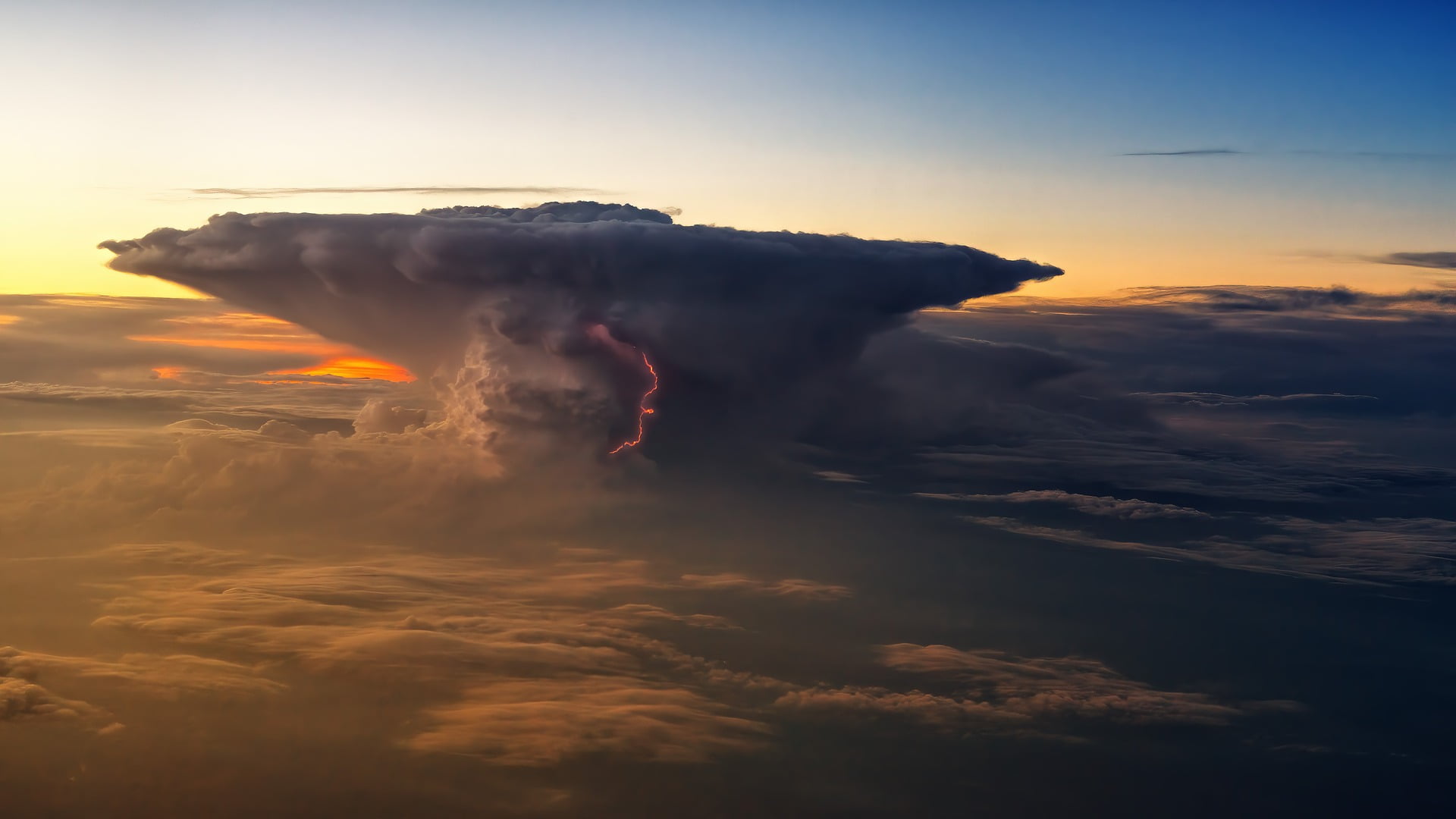
Mountains in the Sky
Our skies can sometimes presage the weather to come. In thunderstorms, a cirrus plume above an anvil cloud will often appear (visible by satellite) about half an hour before severe conditions are reported on the ground. A new study delves into the origins of these plumes and finds that they result from an internal hydraulic jump in the storm that acts a bit like an artificial mountain, driving air — and the moisture it contains — higher in the stratosphere than normal. Once the jump is established, the authors found it could drive 7 tonnes per second of water vapor into the stratosphere! (Image credit: jplenio; research credit: M. O’Neill et al.; via Science)

Bullseye
The Cumbre Vieja volcano in the Canary Islands began erupting in mid-September 2021. This satellite image, captured October 1st, shows a peculiar bullseye-like cloud over the volcano. Hot water vapor and exhaust gases rose rapidly from the erupting volcano until colliding with a drier, warmer air layer at an altitude of 5.3 kilometers. The warm upper layer, known as a temperature inversion, prevented the volcanic gases from rising any further, so they instead spread horizontally. The outflow from the volcano varies and is non-uniform, and its fluctuations generated gravity waves that are visible here as the expanding rings of clouds. (Image credit: L. Dauphin; via NASA Earth Observatory)

Noctilucent Clouds
Noctilucent clouds are the “highest, driest, coldest, and rarest clouds on Earth.” Formed in the mesosphere at altitudes over 80 kilometers, these clouds typically form at polar latitudes where they can catch sunlight hours after sunset, hence their night-shining name. The clouds take shape when water vapor in cold mesospheric air layers freezes onto dust left behind by meteors.
Fun fact: because of their high altitude and particle size and density, noctilucent clouds were considered a hazard for space shuttle reentry, and planners explicitly avoided trajectories that would take the spacecraft near potential clouds. (Image credit: top – N. Fewings, other – J. Stevens/NASA Earth Observatory)


Rainfall Beyond Earth
Rain is not unique to our planet: Titan has methane rain and exoplanet WASP 78b is home to iron rain (ouch). A new study examines rainfall across planets from the perspective of individual rain drops. The authors examine raindrop shape, terminal velocity, and evaporation rate as a function of droplet size for a wide range of known and speculated atmospheres.
They found that raindrops are surprisingly universal. Although planets with higher gravity tend to produce smaller raindrops, they found a remarkably narrow range for maximum drop size. That’s a pretty wild result, all things considered! The idea that iron, ammonia, methane, and countless other fluids falling through vastly different atmospheres all share very common characteristics is fascinating. (Image credit: NASA/JPL-Caltech/SwRI/MSSS/Brian Swift; research credit: K. Loftus and R. Wordsworth; via Science News; submitted by Kam-Yung Soh)

Predicting Meteotsunamis
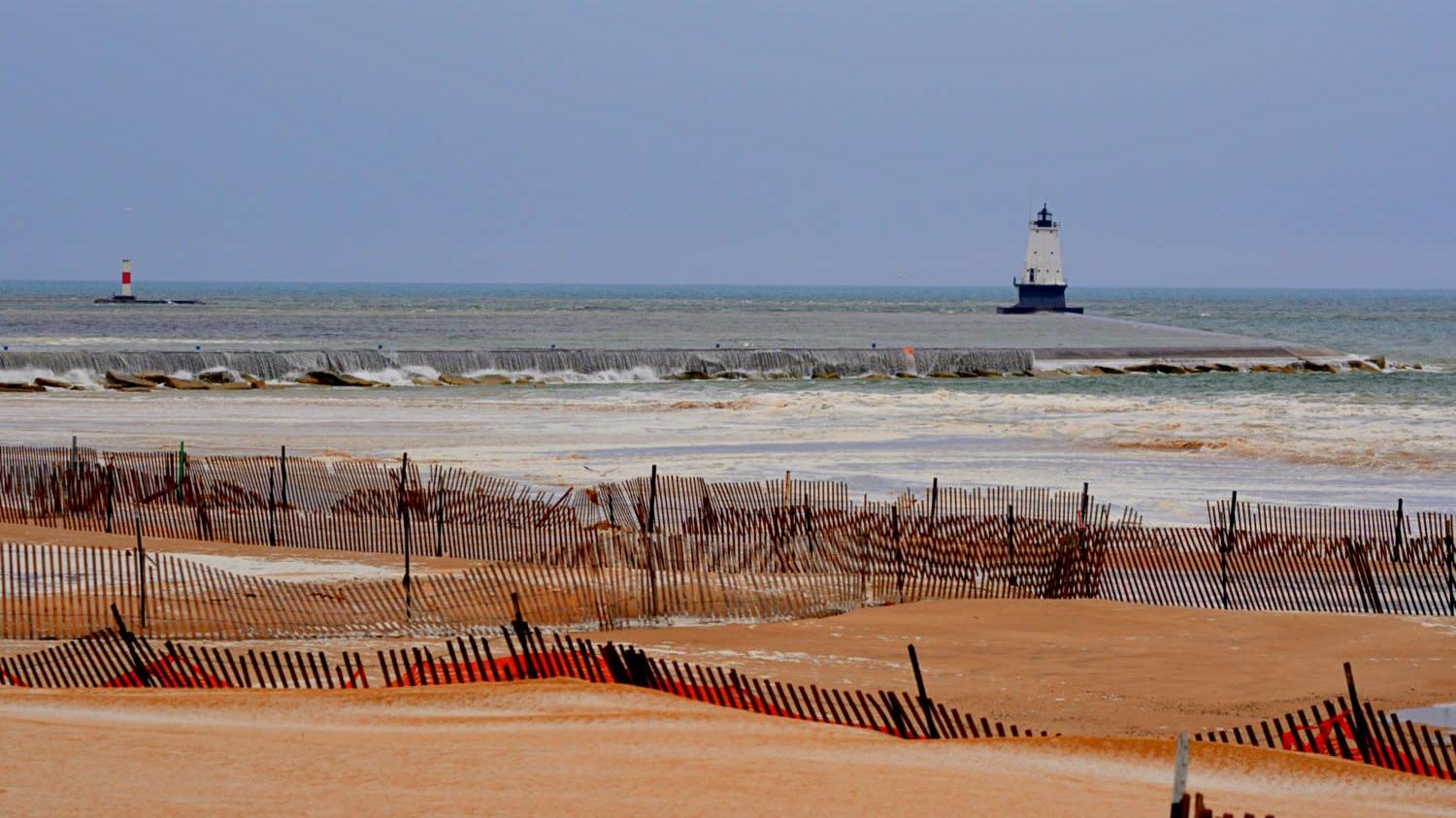


Meteotsunamis, or meteorological tsunamis, are large waves driven by weather rather than seismic energy. Although they occur along shorelines throughout the world, forecasters have very little infrastructure in place to predict or detect them. But a new study of an April 2018 meteotsunami on Lake Michigan (pictured above) has provided evidence that existing models may be able to forecast these events.
The Lake Michigan meteotsunami was driven by an atmospheric gravity wave, which carried with it a substantial pressure drop. Most of the time such waves travel faster or slower than water waves, and there is little to no interaction. But on this day, the atmospheric wave and the water waves were traveling at the same speed in the same direction, creating a resonance that strengthened the water wave.
Using existing National Oceanic and Atmospheric Administration (NOAA) models, researchers were able to reconstruct the event digitally, with results that agreed well with observations. That success means that forecasters may be able to predict the events ahead of time, potentially saving lives. (Image credit: D. Maglothin; research credit: E. Anderson and G. Mann; via Gizmodo)