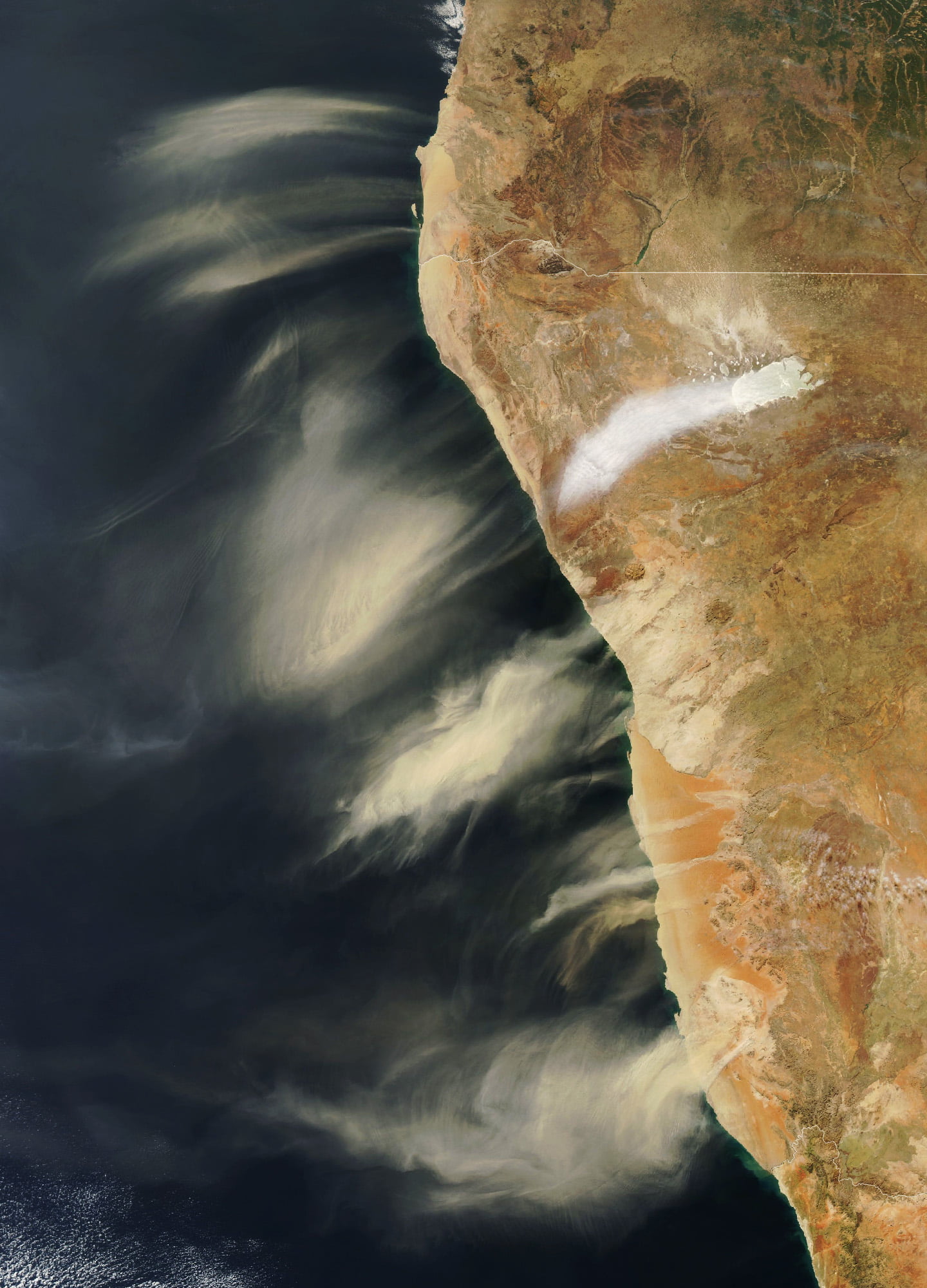
Hot, dry berg winds swept down from the Namibian highlands and sent these plumes of dust flying out to the Atlantic coast. Another plume — white instead of brown — marks salt dust from the Etosha Pan salt flat. The dust and salt become aerosol particles in the atmosphere — seeds for raindrops to form. Coastal towns sometimes need construction equipment to deal with the drifting sand from these storms, but these storms are small compared to Saharan dust storms. Those storms are so large that their dust influences the weather on the other side of the Atlantic. (Image credit: W. Liang; via NASA Earth Observatory)
Tag: atmospheric science

Rolling Over Wisconsin
Although they may look sinister, roll clouds like this one are no tornado. These unusual clouds form near advancing cold fronts when downdrafts cause warm, moist air to rise, cool below the dew point, and condense into a cloud. Air in the cloud can circulate around its long horizontal axis, but the clouds won’t transform into a tornado. Roll clouds are also known as Morning Glory clouds because they often form early in the day along the Queensland coast, where springtime breezes off the water promote their growth. The clouds do form elsewhere, though; this example is from Wisconsin in 2007. (Image credit: M. Hanrahan; via APOD)

Clouds Down Under
This large and unusual cloud formation was captured one July morning over western Australia. Stretching over 1,000 kilometers, the clouds have interesting features at both the large and small scale. The small-scale ripples within the clouds are gravity waves triggered by the terrain below. The larger, arced features are tougher to explain, though they may also be related to gravity waves and terrain, just on a much larger scale. They also resemble fallstreak clouds where supercooled droplets evaporate from the inside of the cloud out. (Image credit: W. Liang; via NASA Earth Observatory)

“Vorticity 5”


Photographer and stormchaser extraordinaire Mike Olbinski is back with the fifth volume in his “Vorticity” series. Shot over the 2022 and 2023 tornado seasons in the U.S. Central Plains, this edition has virtually everything: supercells, microbursts, lightning, tornadoes, and haboobs. There’s towering convection and churning, swirling turbulence. It’s a spectacular look at the power and grandeur of our atmosphere. (Video and image credit: M. Olbinski)

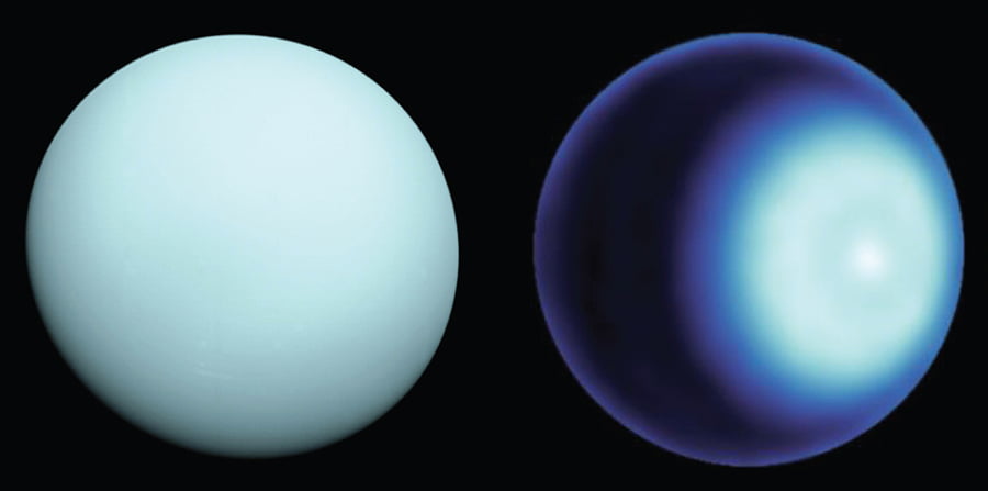
Uranus’s Polar Cyclone
Uranus is an oddity among the planets of our solar system. Where other planets spin around an axis roughly in line with their orbital axis, Uranus spins on its side, placing its poles in line with the sun. On Earth, the polar regions are naturally colder the equator, but that doesn’t hold true for Uranus. Yet new observations of the ice giant show that it, like the other planets with atmospheres in our solar system, has a polar cyclone.
Those observations are thanks to improvements in radio astronomy over the past couple decades. Uranus’s odd orbital geometry means that each of its poles are hidden from Earth for 42 years at a time; the current northern-hemisphere spring marks our first view of Uranus’s northern pole since 1965. In the recent observations, researchers saw a bright spot on the pole, surrounded by a faint darker ring. The team modeled the temperature and gas composition necessary to match their observations and found that those patterns were consistent with a cyclone sitting at the northern pole. (Image credit: NASA/JPL-Caltech/VLA; research credit: A. Akins et al.; via Physics Today)

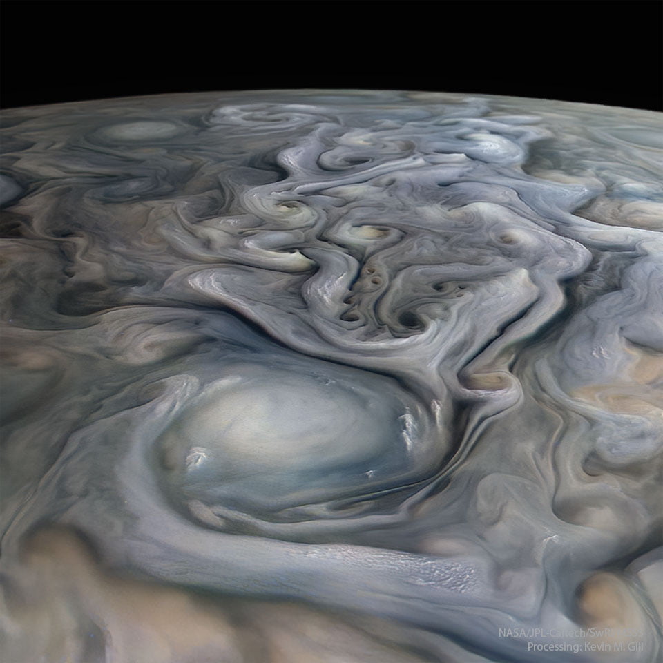
Jovian Swirls
Jupiter, our solar system’s stormiest planet, shares many similarities with Earth. But where Earth’s strongest storms are cyclones centered on low-pressure regions, Jupiter’s longest and strongest storms are anti-cyclones, driven by areas of high pressure. They’re often massive — larger than the entire Earth — and persist for weeks, months, or years. This processed image comes from the JunoCam instrument and shows some of the incredible cloud structure in Jupiter’s atmosphere. Jupiter’s highest altitude clouds tend to be the lightest, while darker clouds remain lower. (Image credit: NASA/JPL-Caltech/SwRI/MSSS/K. Gill; via APOD)

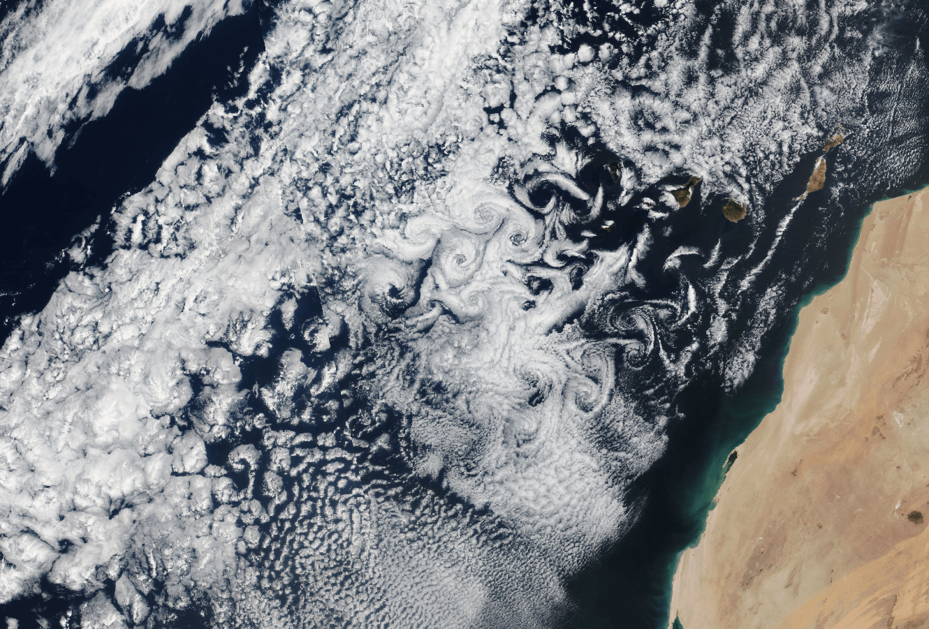
Swirls Over the Canaries
Rocky, isolated islands disturb the atmosphere, sending air swirling off one side of the island and then the other. The effects are not always visible to the naked eye, but, as they do here, they can show up in satellite imagery as whirling von Karman vortex streets. The eddies of this image are due to the Canary Islands, and if you follow the line of swirls backward, you’ll find their originating islands. Note that the cloudy swirls don’t appear immediately behind the islands. That’s because there wasn’t enough moisture in the air for clouds to condense yet; the same swirls that you see in the downstream clouds exist in the clear air closer to the islands. (Image credit: A. Nussbaum; via NASA Earth Observatory)

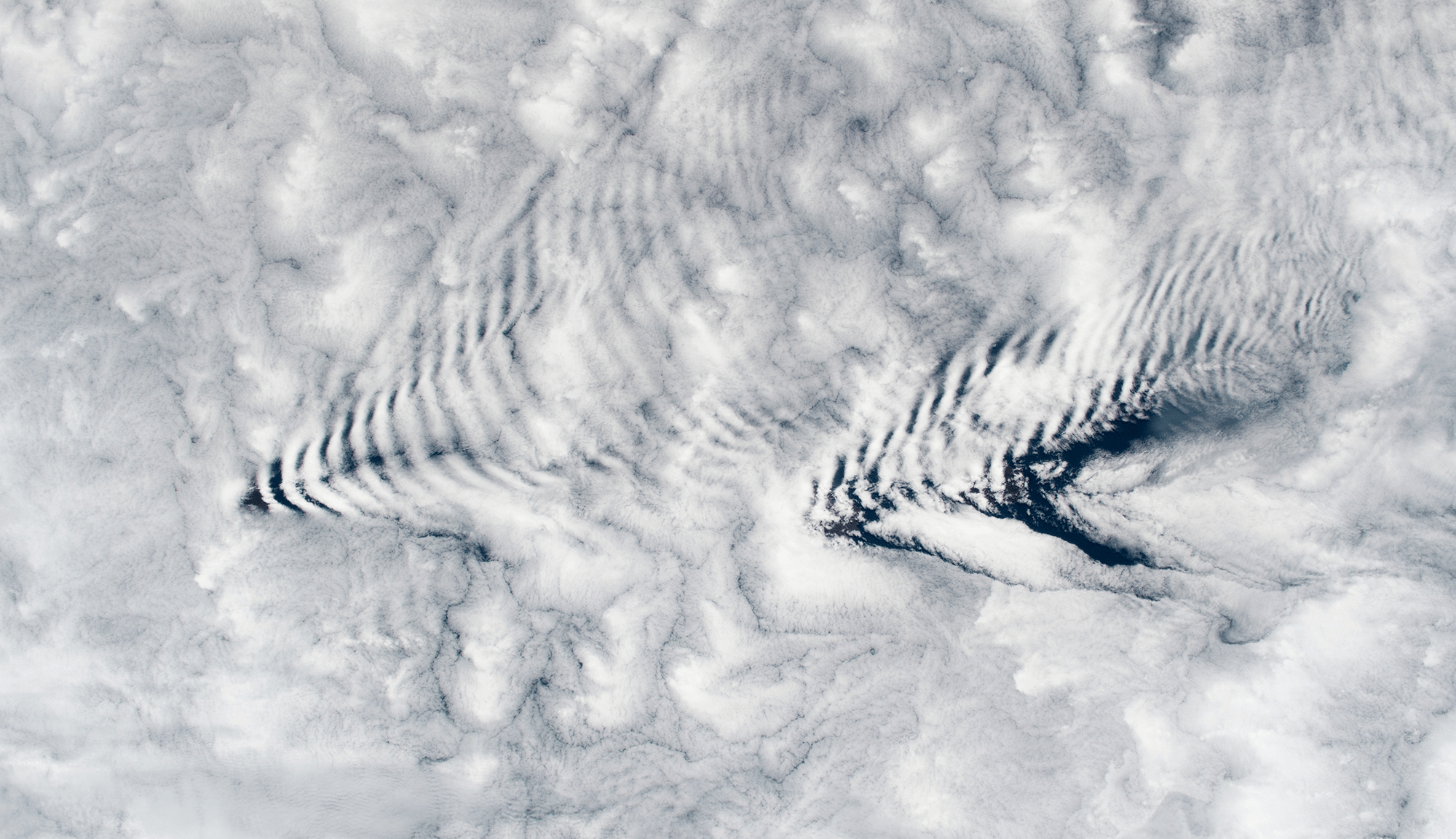
Wave Clouds From Space
An astronaut snapped this image of wave clouds formed around the Crozet Islands, which lie between South Africa and Antarctica. Clouds like these form when warm, moist air gets pushed up and over a mountain. As it rises, the air cools and its pressure decreases, causing condensation. Pushed out of equilibrium, gravity then pulls the air back downward in the wake of the mountain. That warms the air, causing evaporation. Like a mass bouncing on a spring, the air continues to yo-yo up and down, forming cloudy stripes and clear ones until the energy from its mountain climb is spent. (Image credit: NASA; via NASA Earth Observatory)

How Squall Lines Form
Summertime in the middle U.S. means thunderstorms, many of which can form long lines of storms known as squall lines. Complex convective dynamics feed such storms. Here is an illustration of one part of a squall’s lifecycle:

As rain falls and evaporates, it fuels the formation of a cold pool of air below the cloud. Incoming wind (gray arrows) blocks the cold pool from spreading. In turn, the cold pool acts as a ramp that redirects this warm, moist air upward. The vertical variation in wind speed (wind shear, shown with pink arrows) creates a positive vorticity. Together with the negative vorticity in the cold pool, this induces a vorticity dipole that lifts air and moisture, feeding the growing line of storms. As it falls, rain evaporates, cooling air near the ground and forming a cold pool. If incoming winds block the cold pool from spreading, the pool will act instead as a ramp that redirects the wind upward, carrying any warmth and moisture up into the storm cloud. Wind shear — a vertical variation in wind strength with altitude — creates positve vorticity that opposes the negative vorticity inherent to the cold pool. Together these two regions of opposing vorticity lift more air and moisture into the squall, generating more clouds and more rainfall. (Image credit: top – J. Witkowski, illustration – C. Muller and S. Abramian; see also C. Muller and S. Abramian)

Glowing Skies
Not every experiment turns out as expected. Photographer Julien Looten expected to capture the Milky Way arching across the sky above this French chateau. But the photo’s most striking feature is instead the airglow suffusing the sky. The psychedelic colors result from air high in Earth’s atmosphere getting excited by sunlight and producing a faint glow of its own. Such airglow is common, though not always easily seen. If you watch videos from the ISS, you may notice the orange arc of airglow over the atmosphere. (Image credit: J. Looten; via APOD)