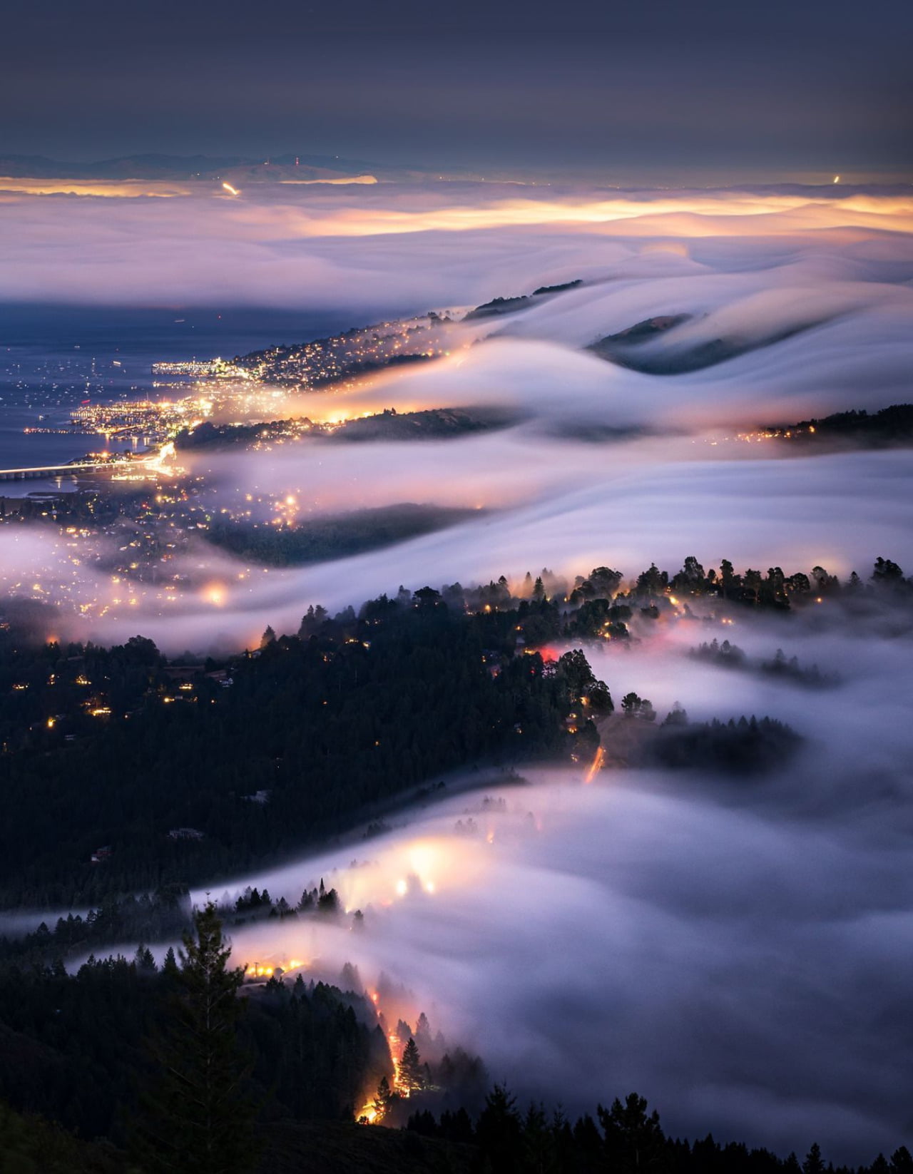
Although we talk about fog rolling in, it’s rare for us to have a perspective where we can truly appreciate that flow. But this photograph from Tanmay Sapkal provides just that for the low summer fogs sweeping over Marin, CA. When hot summer temperatures make inland air rise, cold, moist air from the ocean sweeps in to replace it. Once the moisture condenses, it forms thick, low clouds of fog that surge past the Golden Gate Bridge and into San Francisco Bay. (Image credit: T. Sapkal; via NatGeo)
Tag: atmospheric science

Shedding Light on Martian Dust Storms


In 2018, Mars was enveloped by a global dust storm that lasted for months. Although such storms had been seen before, the 2018 storm offered an unprecedented opportunity for observation from five orbiting spacecraft and two operating landers. As researchers comb through that data, they’re gaining new insights into the mechanisms that drive these extreme events.
At NASA Ames, a team of researchers used observations of dust columns as input to a simulation of Mars’ global climate, then watched as the digital storm unfolded. Simulations like these have an important advantage over observations: the simulations allow scientists to track the transport of dust from one region to another.
That dust tracking is critical for some of the team’s results. They found feedback patterns between dust lifting and deposition in different regions. For example, early in the storm dust was largely supplied from the Arabia/Sabaea regions, but once that dust was deposited in the Tharsis region, it kicked off a massive lifting event from Tharsis that put twice as much dust into the atmosphere as had landed there. Later, dust deposited back in Arabia by the Tharsis lofting generated new dust uplifts. As long as more dust got lifted than deposited, the intense storms continued. (Image credits: NASA, T. Bertrand/A. Kling/NASA Ames; research credit: T. Bertrand et al.; see also JGR Planets and AGU; submitted by Kam-Yung Soh)

The Tolling of the Atmosphere
Strum a musical instrument and you create a host of vibrations at many different frequencies. The same is true of our atmosphere, which rings at frequencies far too low for us to hear. The first theoretical descriptions of this atmospheric ringing date back two centuries to Pierre-Simon Laplace. A new study provides the first experimental evidence of this atmospheric ringing by analyzing 38 years’ worth of hourly atmospheric data.
The authors found good agreement with the structures predicted by classical theory, but they point out that understanding the mechanisms that drive the ringing requires more research. Since studies of vibrations in the Earth and sun have revealed new dynamics in those systems, it’s likely analyses like these can teach us much more about how our atmosphere functions. (Image credit: NASA; research credit: T. Sakazaki and K. Hamilton; submitted by K. Hamilton)

Mammatus Clouds
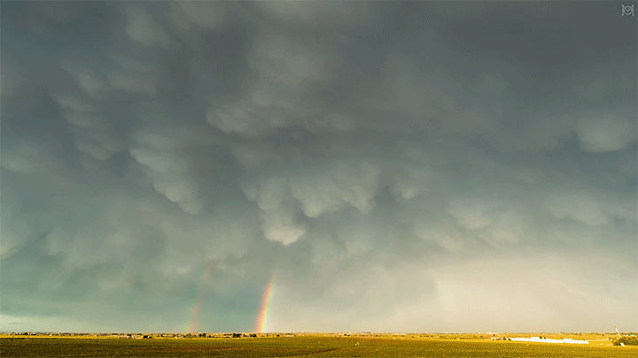

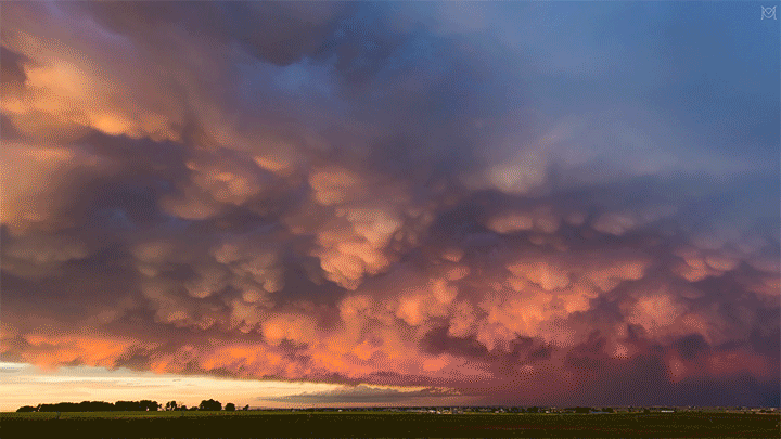
Mammatus clouds are a relatively rare and dramatic variety. One advantage of living in Colorado is that I see them somewhat often, especially during our stormy springs and summers. This video by Mike Olbinski features a dramatic skyscape of mammatus clouds (here in Colorado, natch) at sunset.
Although they’re often associated with stormy weather, there’s no widely accepted theory as to how mammatus clouds form. Their lobe-like protrusions form from cold, sinking air, but this is about as far as theories agree. It’s even unclear what their relation to extreme weather may be since these short-lived cloud formations can appear around, before, or even after such weather. (Image and video credit: M. Olbinski)

Jupiter in Infrared


This stunning new image of Jupiter in infrared is part of a data set combining measurements from ground- and space-based observatories. The glowing Jovian orb seen here is a composite of some of the sharpest images captured by the Gemini North Telescope’s Near-Infrared Imager from its perch on Mauna Kea. The brightest areas correspond to warmer temperatures over thinner, hazier clouds, whereas the dark areas mark towering, thick clouds.
The ground-based images — and observations from Hubble — were timed to coincide with passes from the Juno spacecraft. This combination of infrared, visible light, and radio wave observations gives scientists an unprecedented look at Jovian atmospheric processes. It revealed, for example, that lightning measured by Juno deep inside Jupiter’s atmosphere corresponded to convective storm cores visible to the other imagers. The combination of observations allowed the researchers to reconstruct the structure of these Jovian storms in a way that no single instrument could reveal. No doubt planetary scientists will learn lots more about Jovian convection from the data set. (Image credit: Jupiter – International Gemini Observatory/NOIRLab/NSF/AURA, M.H. Wong (UC Berkeley)/Gizmodo, illustration – NASA, ESA, M.H. Wong (UC Berkeley), and A. James and M.W. Carruthers (STScI); research credit: M. Wong et al.; via Gizmodo)
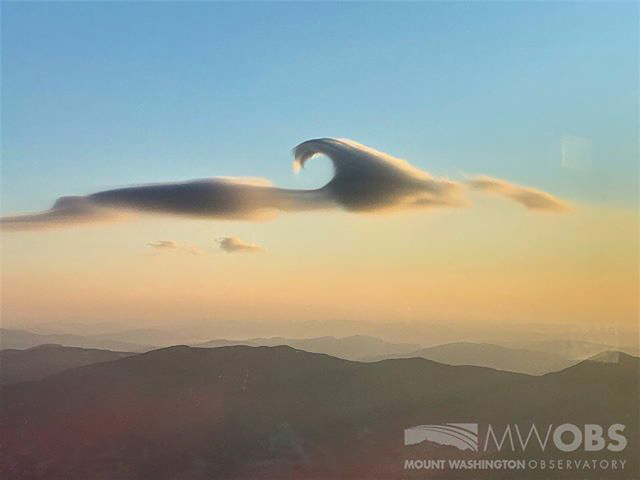
A Lenticular Cloud With a Curl
Lens-shaped lenticular clouds are not terribly rare in mountainous areas, but observers at Mount Washington caught a very unusual cloud near sunrise in late February. This lenticular cloud had an added curl on top thanks to the Kelvin-Helmholtz instability!
Lenticular clouds form when air is forced to flow up over a mountain in such a way that its temperature and pressure drop and water vapor in the air condenses. The resulting water droplets form a cloud that appears stationary over the mountain, even though the air continues to flow.
To get that added wave-like curl, there needs to be another, faster-moving layer of air just above the cloud. As that air flows past, it shears the cloud layer, causing the interface to curl. Neither of these cloud types is long-lived — Kelvin-Helmholtz formations often last only a few minutes — so catching such a great dual example is lucky, indeed! (Image credit: Mount Washington Observatory; via Smithsonian Magazine; submitted by Kam-Yung Soh)
A Year From Geostationary Orbit

Our planet is a complex fluid dynamical system, and one of the best ways to watch nature at work is through timelapse. This short film takes us through an entire year, from December 2015 to December 2016, as viewed from a geostationary weather satellite centered over Oceania.
The imagery is rather hypnotic, with clouds swirling day and night across the full field of view. Watch closely, though, and you’ll see a lot of neat phenomena from typhoons forming in the Pacific to wave clouds streaming from the islands of Japan. You can also see clouds blossoming (especially during the day) over the humid rainforests of Oceania.
There are neat non-fluids phenomena, too, like a total solar eclipse and the permanent sunlight of Arctic and Antarctic summers. What do you notice? (Image and video credit: F. Dierich)

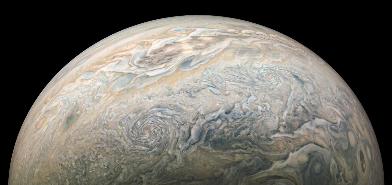
Jovian Vortices


Jupiter continues to mesmerize in the images from JunoCam. With enhanced contrast, the planet’s eddies look like swirls you could just lean forward and fall into. The complexity of the Jovian atmosphere’s mixing is just astounding. It’s like an ever-changing Impressionist painting brought to life. Check out full-size versions of these stunning images here and here. (Image credit: NASA/JPL-Caltech/SwRI/MSSS/Kevin M. Gill, 1, 2; via Planetary Society; submitted by jpshoer)
“Vorticity 2”


There’s no better way to appreciate our atmosphere than through timelapse, and photographer Mike Olbinski is a master at capturing the beauty and power of nature at work through this medium. In “Vorticity 2″, he highlights two full seasons of storm chasing in an incredible seven-and-a-half minutes. Prepare yourself for dramatic cloudscapes, torrential rains, and even twin tornadoes. This one deserves a watch on the biggest screen you have available. (Image and video credit: M. Olbinski; via Colossal)

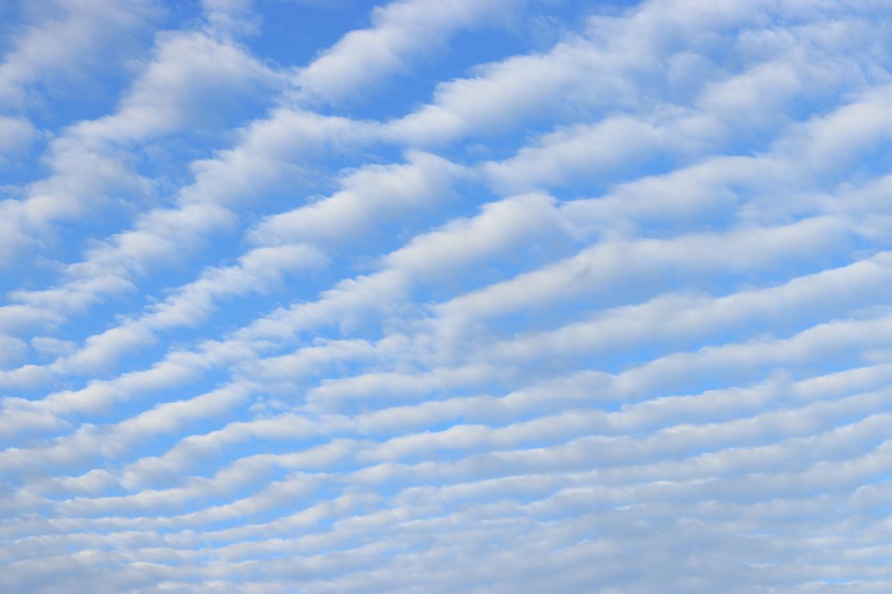
Striped Clouds
Living near the Rocky Mountains, it’s not unusual to look up and find the sky striped with lines of clouds. Such wave clouds are often formed on the lee side of mountains and other topography. But even in the flattest plains, you can find clouds like these at times. That’s because the internal waves necessary to create the clouds can be generated by weather fronts, too.
Imagine a bit of atmosphere sitting between a low-pressure zone and a high-pressure zone. This will be an area of convergence, where winds flow inward and squeeze the fluid parcel in one direction before turning 90 degrees and stretching it in the perpendicular direction. The result is a sharpening of any temperature gradient along the interface. This is the weather front that moves in and causes massive and sudden shifts in temperature.
On one side of the front, warm air rises. Then, as it loses heat and cools, it sinks down the cold side of the front. The sharper the temperature differences become, the stronger this circulation gets. If the air is vertically displaced quickly enough, it will spontaneously generate waves in the atmosphere. With the right moisture conditions, those waves create visible clouds at their crests, as seen here. For more on the process, check out this article over at Physics Today. (Image credit: W. Velasquez; via Physics Today)
