In January 2022, the Hunga Tonga-Hunga Ha’apai volcano erupted spectacularly, sending waves around the world through the air, water, and ground. In many ways, it was unlike any eruption scientists have observed, though they think it bears similarities to the 1883 eruption at Krakatoa. This video summarizes some of the research to come out of the eruption, looking at how waves propagated, what aerosols the volcano pushed high into the atmosphere, and what the long-term effects of the eruption may be. (Video credit: Science)
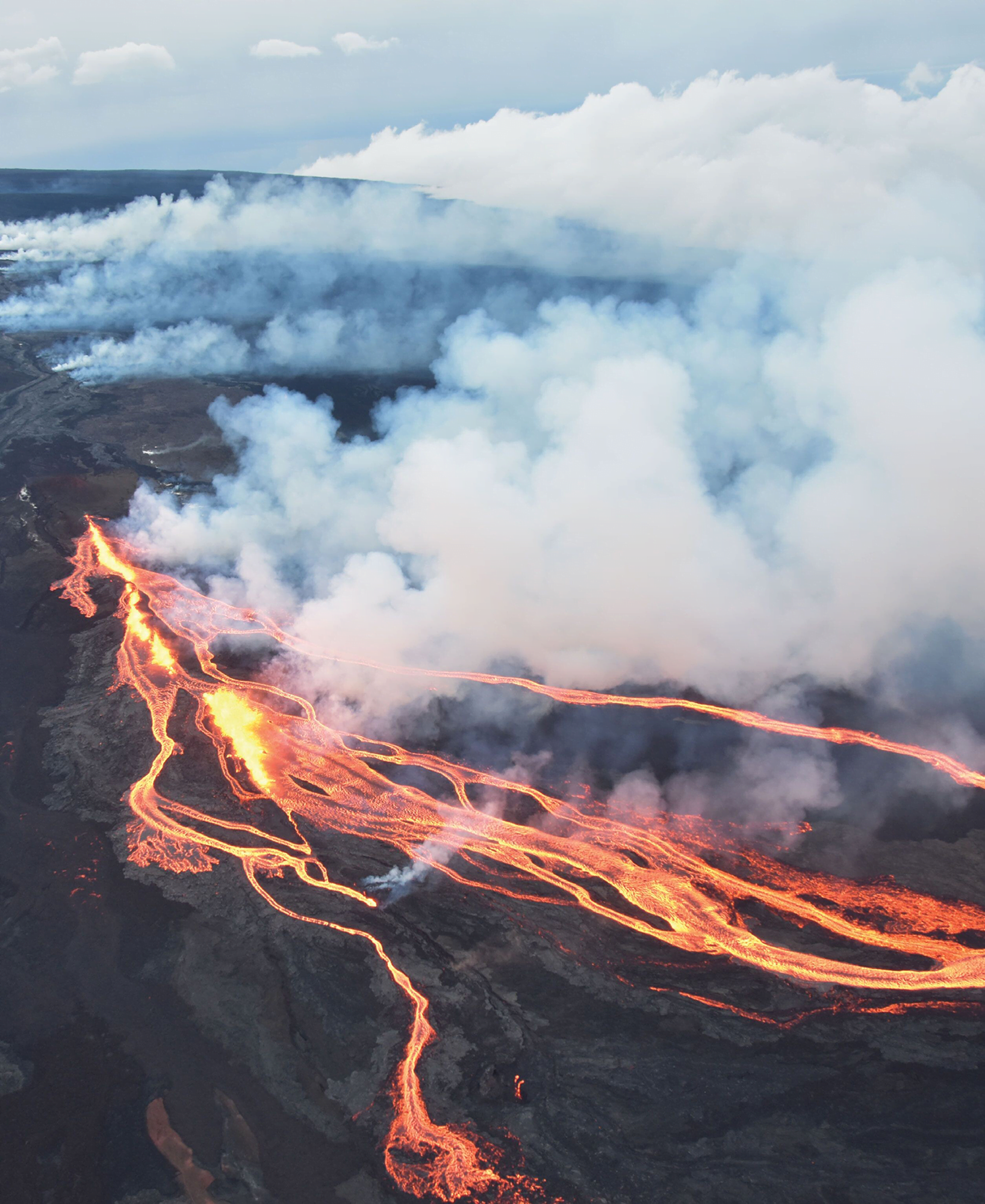
Volcanoes are endlessly fascinating to watch, especially in this era of drone photography. Joey Helms’s short film “The Beauty in Creation” shows the Fagradalsfjall eruption in Iceland. Sail over rivers of lava, watch fountains spurting, and even see lava dripping back into the caldera. They’re views that no human gets to witness directly, but they certainly do highlight the peculiar collision of destruction and creation inherent in volcanic eruption. (Video credit: J. Helms)
Few volcanoes are as well-studied as those of the Big Island of Hawai’i. With a host of seismic monitors and frequent eruptions, scientists know the near-surface region of Hawai’i well. But a recent study looked at nearly 200,000 seismic events after the 2018 collapse of Kilauea’s crater and found hints of what goes on much deeper.
Mapping out earthquakes beneath the island revealed a cluster of activity near a village named Pahala. These earthquakes took place 36 to 43 kilometers below the surface and seem to be connected to magma filling a sill complex there. From that deep reservoir, the team was also able to map seismic activity leading upwards to both Kilauea and Mauna Loa volcanoes. Despite the 34 kilometers between those two volcanoes, they appear to be fed through the same web of magma! (Image credit: top – USGS, illustration – J. Wilding et al.; research credit: J. Wilding et al.; via Physics Today)
This cartoon illustrates the web of magma linking Kilauea and Mauna Loa deep underground.
Lava spurts from the Fagradalsfjall volcano in Iceland in this award-winning photo by Riten Dharia. It’s always bizarre to see molten rock flowing in fountains and rivers because it’s so unlike our daily experiences. Some deeply buried areas of the Earth, including the outer part of the core, are often described as liquid rock, which brings to mind lava. But that’s not, in fact, what those regions are like. If you were to visit Earth’s outer core in some super-submersible, you would not find a sea of lava. Instead, you would find yourself surrounded by what seemed to be solid rock. That’s not to say that the outer core is solid — just that it flows on geological timescales that are far longer than any human’s lifetime! (Image credit: R. Dharia; via Gizmodo)
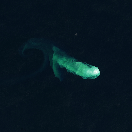
This pale green plume signals the activities of Kaitoku, an underwater seamount near Japan. Periodic activity picked up there in August 2022 and continued into the new year. The rising plume likely consists of superheated acidic seawater mixed with particulates, sulfur, and rock fragments. Underwater volcanoes like this one are thought to account for up to 80 percent of our planet’s volcanic activity. (Image credit: L. Dauphin; via NASA Earth Observatory)
Lots of beverage-inspired posts this time around! It’s a good reminder that there’s always interesting science around us all the time. Also, a special shout out to Steve Mould, whose videos appear in three of the top ten posts of the year – wow! Congrats, Steve!
If you enjoy FYFD, please remember that it’s a reader-supported website. I don’t run ads and it’s been years since my last sponsored post. You can help support the site by becoming a patron, making a one-time donation, buying some merch, or simply by sharing on social media. And if you find yourself struggling to remember to check the website, remember you can get FYFD in your inbox every two weeks with our newsletter. Happy New Year!
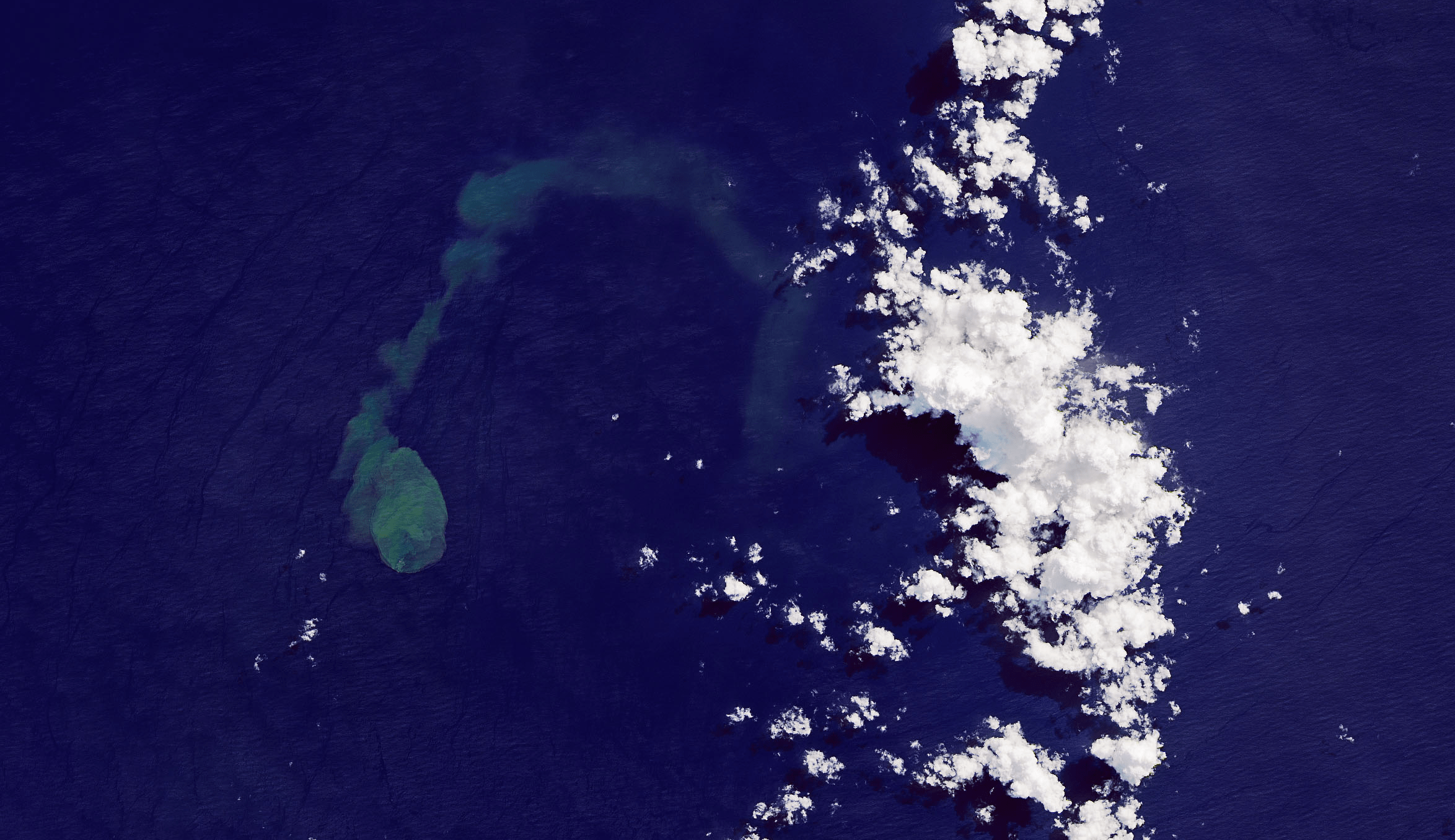
The green-blue plume on the left of this satellite image is an eruption from Kavachi, an underwater volcano in the Solomon Islands. Kavachi’s crest is currently estimated to lie 20 meters below the surface, with its base at a depth of 1.2 kilometers. Eruptions are quite common at the volcano, but that doesn’t stop wildlife — like hammerhead sharks! — from making the crater their home. Over the last century, Kavachi’s eruptions have repeatedly formed small islands at the surface, but they were quickly eroded away by wave action. (Image credit: J. Stevens/NASA/USGS; via NASA Earth Observatory)
Yellowstone National Park is filled with geysers, hot springs, and mudpots — all geophysical features driven by the underground movement of water heated by the underlying volcano. But what does that underground plumbing look like? To find out, a team of researchers flew a 25-m diameter electromagnetic loop over portions of the park; they used the electromagnetic feedback induced in the loop to roughly map the subsurface features of the park.
To their surprise, they found that deep hydrothermal vents in Yellowstone lie in discrete locations; previously, geologists assumed the vents were more widespread. With a better sense of what lies beneath, park officials will be able to build new infrastructure in areas better protected from one of the park’s biggest hazards: hydrothermal explosions caused by a buildup of pressure underground. (Image credits: top – I. Shturma, map – C. Finn et al.; research credit: C. Finn et al.; via Physics World)
Editor’s Note: This article was written and scheduled prior to the historic flooding in Yellowstone in June 2022.
Geophysical map of Yellowstone’s Upper Geyser Basin, including Old Faithful.
Today’s video is something a little different. Rather than looking at fluids and their physics directly, we’ll take a step back and think about how people relate to the subject. This short film, “Volcano Pilot,” follows Haraldur Unason Diego as he reflects on his life’s work. It’s a beautiful and moving glimpse of the life and philosophy of a small aircraft pilot. Many people never have the opportunity to see the world from cockpit of a Cessna or similar small aircraft, and I think there are few experiences that can better connect someone to the fluids-in-action that is aviation. (Image and video credit: M. Aberra et al.)
In 1883, the eruption of Krakatau (also called Krakatoa) shook the world, sending shock waves and tsunamis ricocheting across the globe. Some of the smaller waves hit shorelines in the Atlantic and Pacific that were entire continents and ocean basins away from the original explosion. At the time, scientists were so perplexed by the phenomenon that they blamed coincidental earthquakes for the wave action.
Only when Tonga experienced a similarly devastating volcanic eruption earlier this year were scientists able to verify what they’d long suspected: these smaller tsunamis were not caused by solid material displacing water; instead they are the result of atmospheric pressure waves coupling to the ocean. Follow the full story over at Quanta. (Image credit: M. Barlow; via Quanta; submitted by Kam-Yung Soh)


 and its spike proteins (blue), surrounded by mucins (red), surfactants (green), and deep lung fluid (orange).")