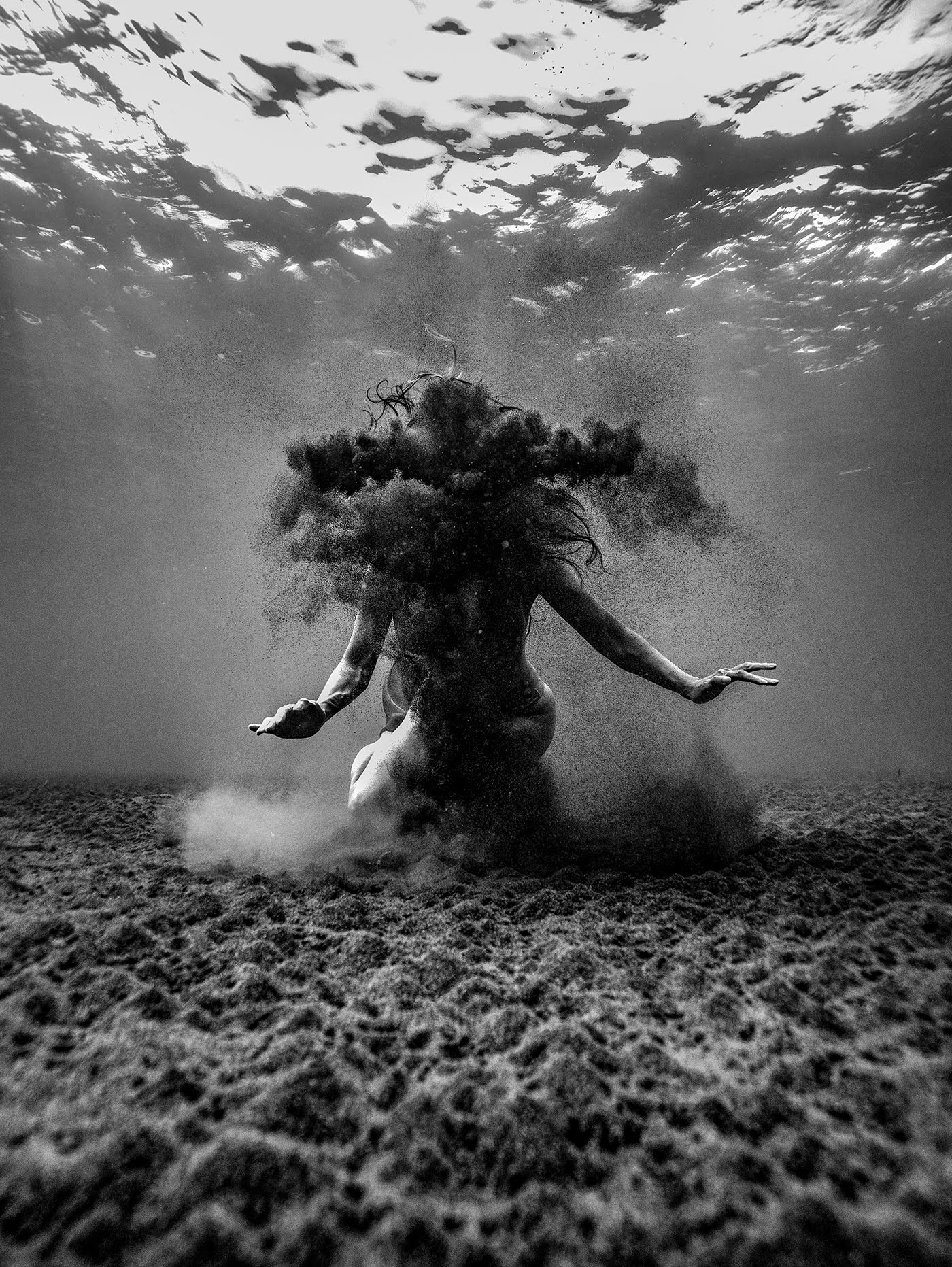
A woman hides in silt and sediment in this award-winning underwater photo by Lee Jongkee. The motion of her plunge sends water spinning downward, where it picks up particles from the ground. Slow to settle, the sediment forms an ethereal mask for the swimmer. See more of the 2023 Sony World Photography winners here. (Image credit: Lee Jongkee)
Tag: sedimentation

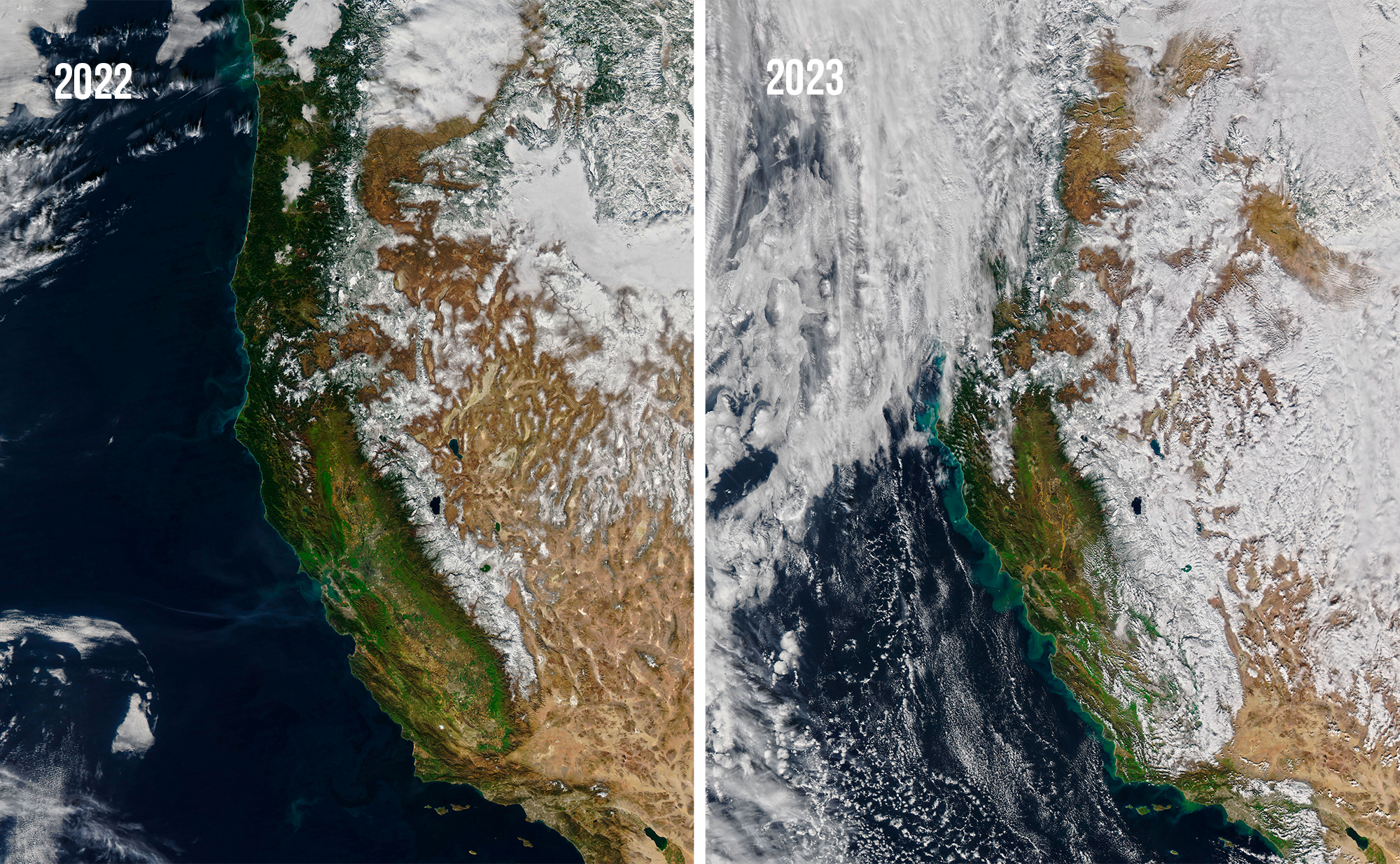
Sedimentation After Flooding
The new year brought California a series of atmospheric rivers that poured record amounts of water onto drought-stricken lands. While the precipitation refreshed snowpacks and reservoirs, much of it washed away as soils oversaturated. Those flows carried sediment with them, creating swirls of brown and green along the coastline.
Compare the two satellite images above to see how different January 2022 looked from January 2023, post-deluge. The snow levels in January 2023 were about 248 percent of their average level for that part of the season. But the sediment levels in the ocean are also drastically increased, indicating high levels of erosion. (Image credit: J. Stevens; via NASA Earth Observatory)

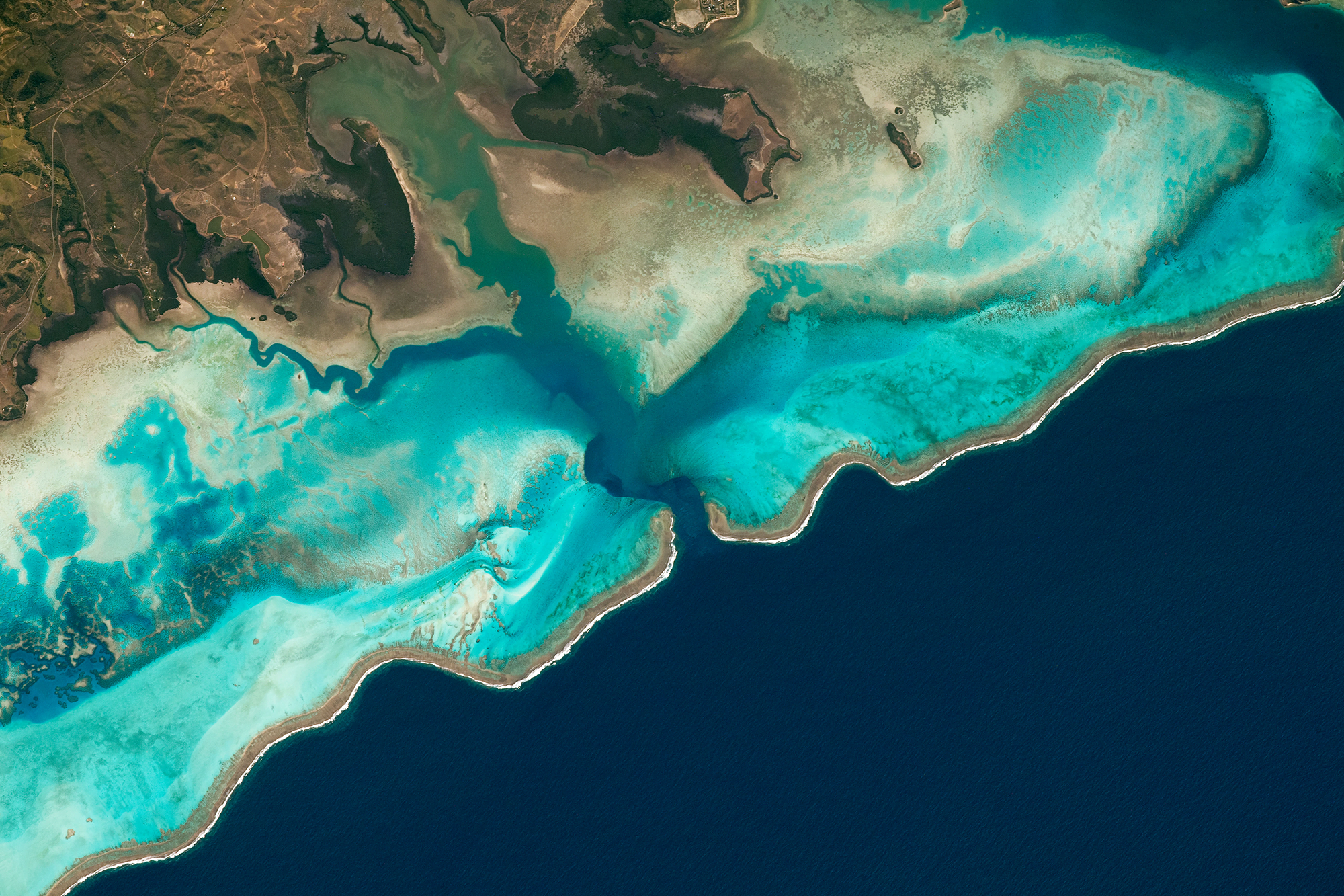
Reefs Along New Caledonia
Brown reefs edge a turquoise lagoon in this astronaut snapshot of the New Caledonian coastline. Reefs like these form a natural barrier that protects coastlines from storms by breaking up waves (seen here as those white edges) before they reach the shore. The lagoon is streaked with lines of tan where sediment flows from the uplands into the water. Similarly, the color variations from green to blue in water hint at changes in depth, organic content, and more. (Image credit: NASA; via NASA Earth Observatory)

Ingenuity’s Dust Cloud


Mars is quite dusty. It periodically gets swallowed by planet-spanning dust storms, but it’s also home to regular dust devils whose size can put Earth’s to shame. Exactly how so much dust gets picked up by Mars’ incredibly thin atmosphere — only 1% of Earth’s — is still something of a mystery. So scientists were excited after the Ingenuity helicopter’s fourth flight, where cameras on the Perseverance rover caught a billowing dust cloud following Ingenuity as it flew. Knowing how the helicopter flies, they may be able to unravel just how its wake picks up and carries dust. Since Ingenuity’s only purpose was to demonstrate flight on another planet, this would be a big scientific bonus for an already successful mission! (Image credit: NASA/JPL-Caltech/ASU/MSSS/SSI; via Nature; submitted by Kam-Yung Soh and jpshoer)

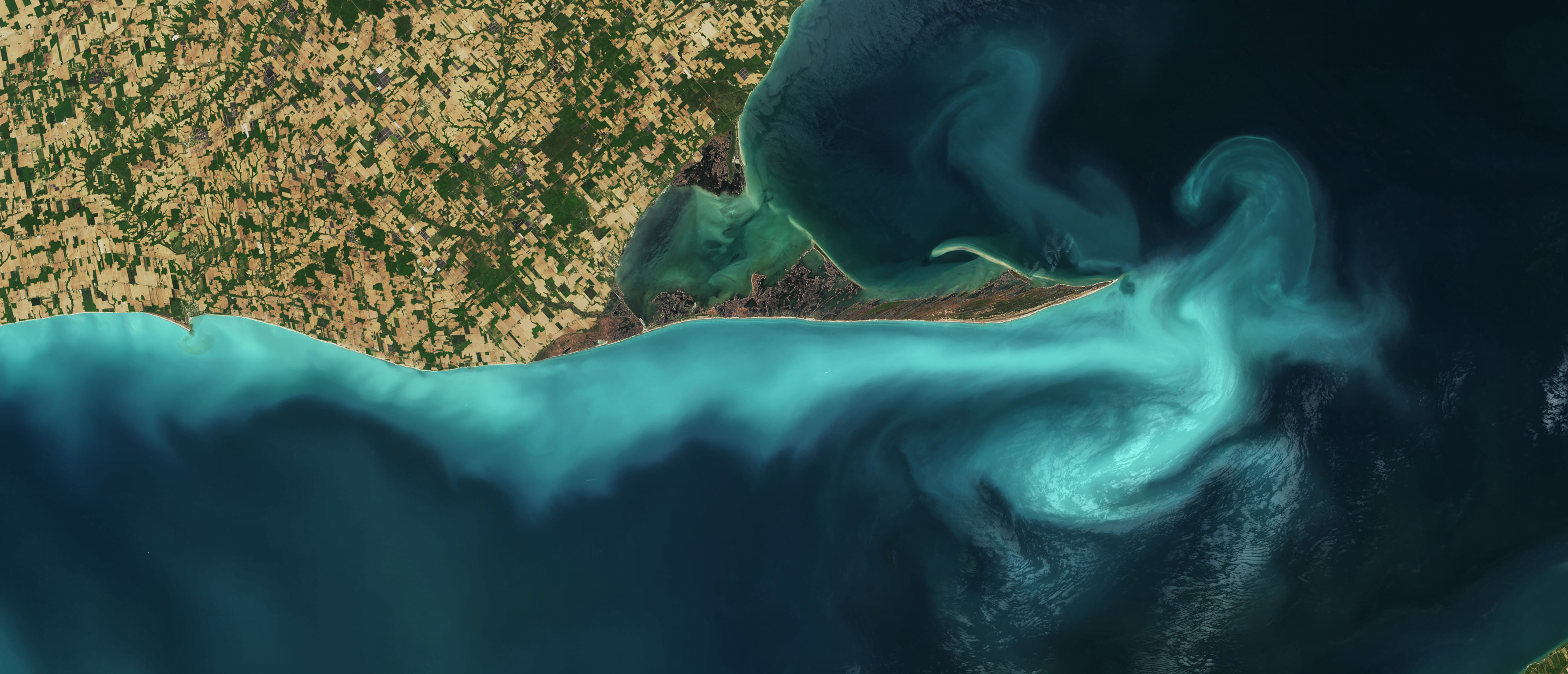
Suspended Sediments in Lake Erie
Lake Erie’s Long Point is outlined in turquoise in this natural-color satellite image. The pale color is likely due to limestone sediments in the shallow waters getting resuspended by a seiche or other disturbance. A seiche is a standing wave that forms in a partially- or fully-bounded body of water; in Lake Erie they are typically wind- and weather-driven. (Image credit: J. Stevens/USGS; via NASA Earth Observatory)

When Rivers Break Their Banks


Rivers often change their course, but they do not always do so gradually. River avulsions are a bit like earthquakes — they happen suddenly and with disastrous potential. Researchers find that these sudden course changes happen when silt builds up in a river and reduces the amount of water it can carry. Eventually, the resistance to flow is large enough that the river bursts its banks in search of an easier route to the sea. That’s a deadly problem for the communities that live nearby and rely on the river’s sedimentation for their fertile farmland. But using small-scale models, scientists are beginning to unravel the physics behind avulsions, bringing hope that they can be predicted or even sustainably averted. (Video and image credit: Science)

Blue Dunes
This false-color image shows a Martian dune field near the northern polar cap. The image itself covers an area 30 kilometers wide, but the dune field stretches over an area the size of Texas. In the photo cooler areas have been rendered in bluer tints, while warm areas are shown in yellow and orange. The sun warms the wind-sculpted dunes more than in the valleys that lie between. Complex dune networks like these build up over time as consistent winds push sand and create interactions between individual dunes. (Image credit: NASA/JPL-Caltech/ASU; via Colossal)
Coastal Erosion


The same dynamic forces that make coastlines fascinating create perennial headaches for engineers trying to maintain coastlines against erosion. This Practical Engineering video discusses some of the challenges of coastal erosion and how engineers counter them.
In a completely undeveloped coastline, waves and storms erode the shoreline while rivers and currents replenish sand through sedimentation. Manmade structures tend to strengthen erosion processes while disrupting the sedimentation that would normally counter it. Beach nourishment — where sand gets dredged up and deposited on a beach — is an engineered attempt to replace natural sedimentation.
Dunes, mangrove forests, and wetlands are all nature’s way of protecting and maintaining coastlines. We engineers are still learning how to both utilize and protect shorelines. (Image and video credit: Practical Engineering)

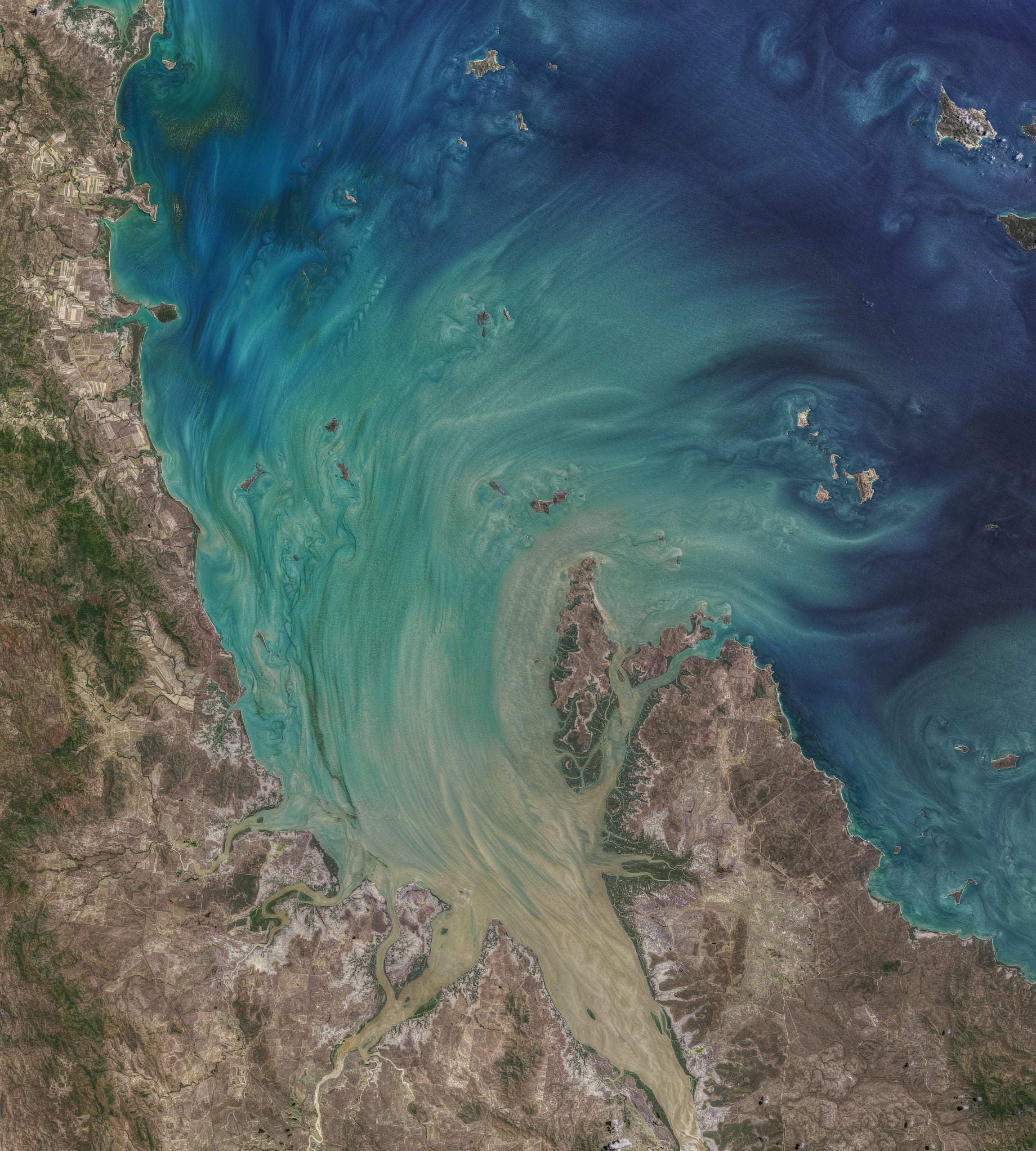
High Tide
Broad Sound, in eastern Australia, is home to some of the most extreme tidal swings in the world, with more than ten meters difference between high and low tides. The bay’s peculiar geography, along with the topography of nearby reefs, combine to cause the large tides. This color-enhanced satellite image shows the bay at high tide, as phytoplankton and suspended sediments are swept into the bay and around its many islands. The level of detail is just stunning. I particularly love all the von Karman vortex streets visible in the wakes of islands. I count more than a dozen of them! (Image credit: N. Kuring/NASA/USGS; via NASA Earth Observatory)

A Colorful Portrait of Flow
This gorgeous, natural-color image shows Lake Balkhash in southeastern Kazakhstan. In early March, the ice on the lake was beginning to break up, revealing glimpses of swirling sediment below the water’s surface. In contrast, the smaller lakes and ponds of the surrounding area remained frozen amidst the wintery browns of the nearby desert and wetlands. (Image credit: J. Stevens/USGS; via NASA Earth Observatory)