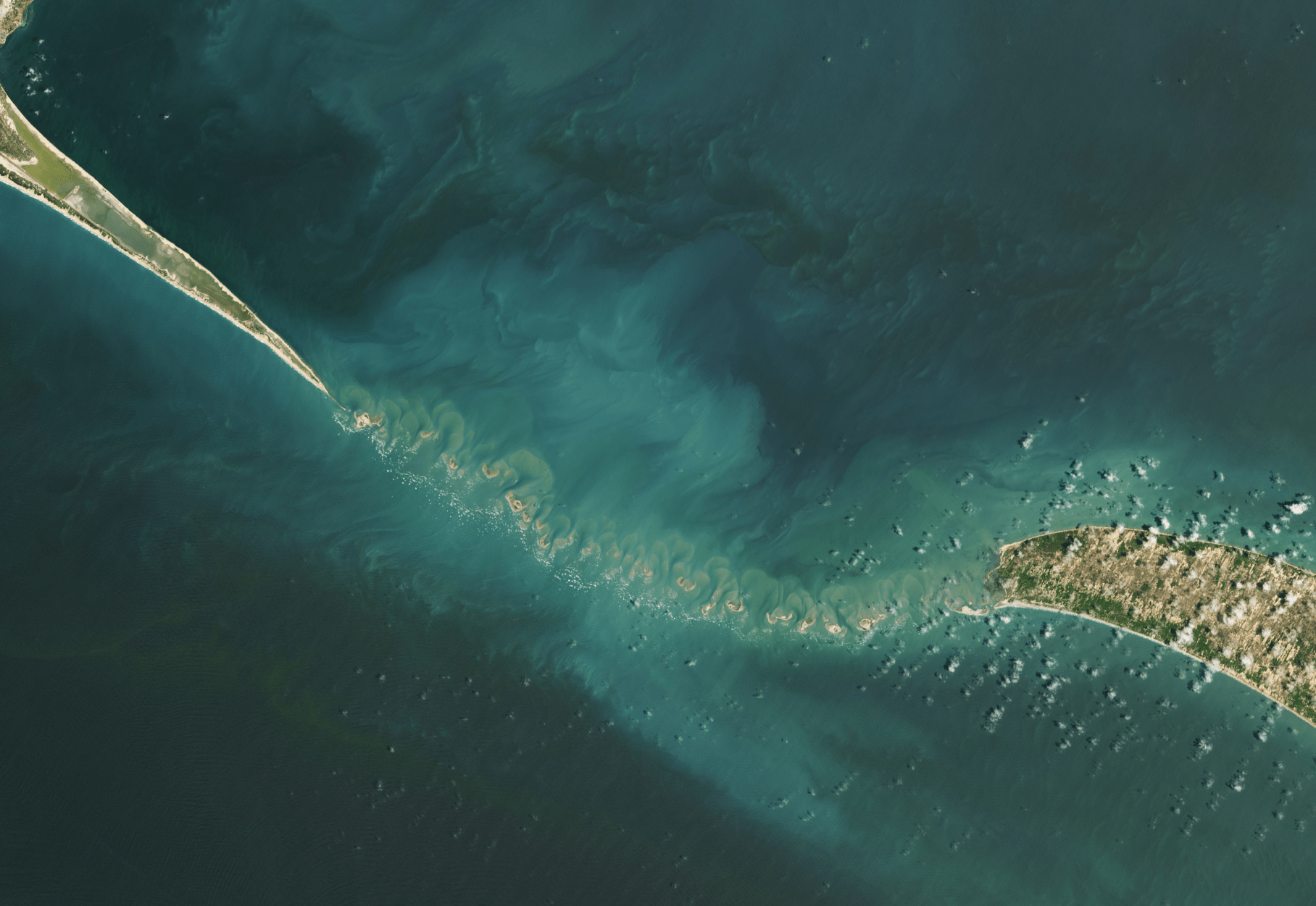
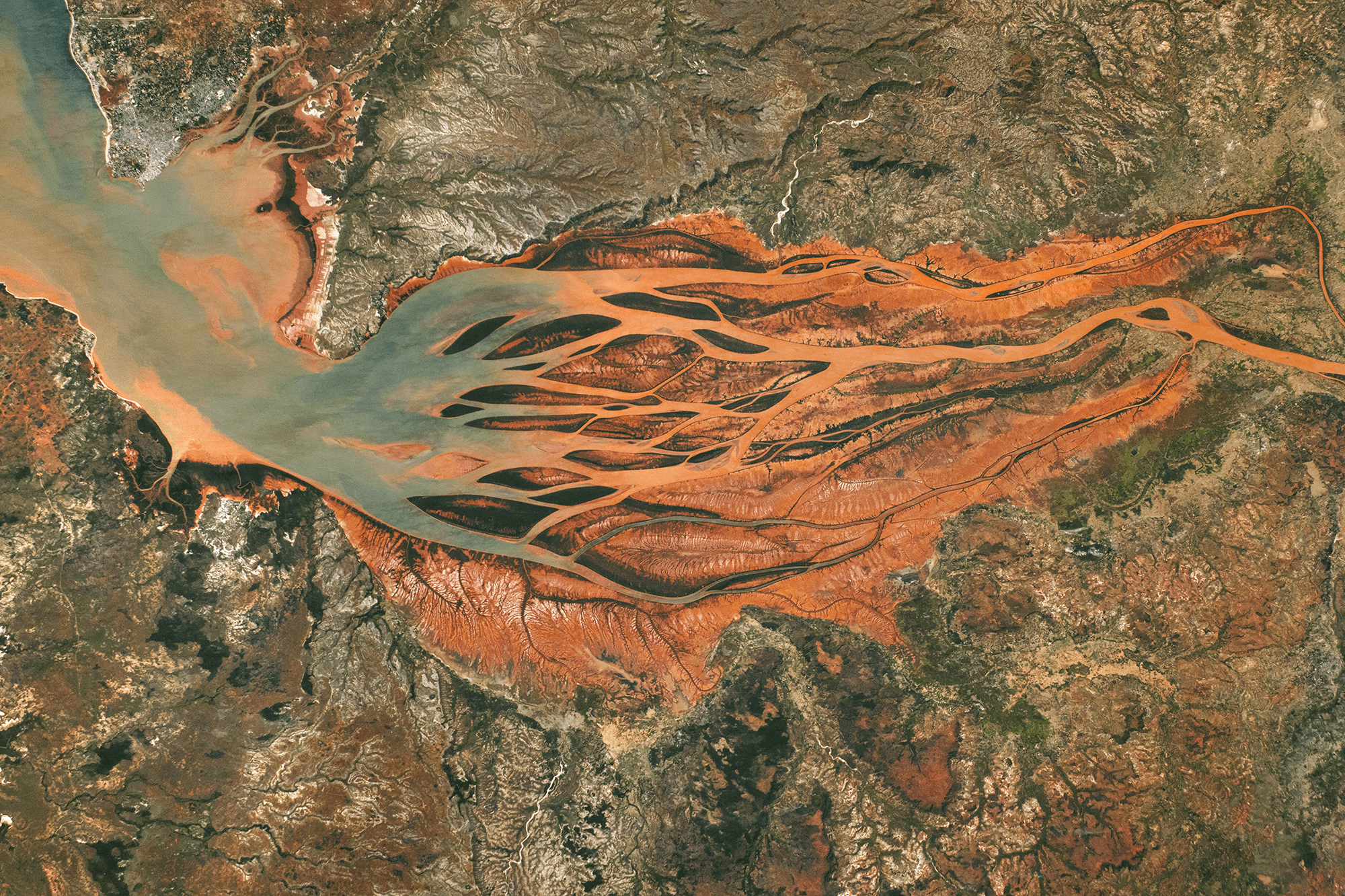
As glaciers flow, they grind down rock, creating fine sediment that dyes waterways a milky color. In Jan Erik Waider’s aerial film, we get a bird’s eye view of the result, watching pockets of sediment move downstream in pulsating waves and swirls. Along the coast, ocean waves pass over the internal ones, creating a mesmerizing crisscrossed wavescape. You can also compare Waider’s aerial footage to Roman De Giuli’s tabletop-scale films and be amazed by their similarities. (Image and video credit: J. Waider; via Colossal)
Tag: sedimentation

Waves Lap on Titan’s Shores
Titan, one of Saturn’s moons, is the only other planetary body known to have liquid lakes, rivers, and seas at its surface. Whether those bodies — made up of hydrocarbons rather than water, like here on Earth — have waves is a matter of ongoing debate. What data we have from visiting spacecraft is inconclusive. So a group of researchers decided to look for the effects of wave action instead.
Beginning with a model of flooded areas similar to Titan’s, the team simulated a coastline’s erosion assuming three different situations: 1) no coastal erosion, 2) erosion from waves, and 3) uniform erosion through dissolution. Each set of conditions resulted in a very different final coastline. But, of the three, the wave-eroded coast was most similar to those seen on Titan. That’s a good indicator that, even if our spacecraft couldn’t see waves on Titan, they’re likely there. (Image credit: ESA; research credit: R. Palermo et al.; via Gizmodo)

Sediment Swirls
Turbulent flows feature swirling eddies over a range of sizes — the larger the size range, the higher the Reynolds number. In this satellite image, sediment highlights these eddies in shades of turquoise, showing off the complexity of the flows created where rivers, ocean, and tides meet. The eddies we see here stretch from kilometers in width down to a handful of meters, but the flow’s turbulence persists down to millimeter-scales before viscosity damps it out. (Image credit: L. Dauphin; via NASA Earth Observatory)

Mardi Gras Pass
The mighty Mississippi River has long been bound by humanity’s efforts. To keep the river in place and control its flooding, engineers have built levees, canals, and other structures. But those efforts have come with costs. Where the wild Mississippi used to deposit sediment and build new land, the bound river sends its sediment out to sea, contributing to wetland erosion. But sometimes the river still exerts its own control.
In 2012, around the time of Mardi Gras, the river broke through its eastern bank (near an existing canal) and created a new channel to the Gulf of Mexico. Known as Mardi Gras Pass, this distributary waterway now contributes fresh sediment, nutrients, and water to the Louisiana wetlands. Despite its small size, observations indicate that the Mardi Gras Pass is, indeed, helping to build new land in the area. (Image credit: J. Stevens; via NASA Earth Observatory)

Ancient River Branch Discovered Near Giza Pyramids
Today the pyramid complex at Giza sits kilometers from the Nile River, raising longstanding questions about how ancient builders moved the enormous stones that make up each structure. A new study using radar satellite imagery, geophysical data, and deep soil coring identified a previously unknown ancient branch of the Nile that ran alongside the Giza Pyramids as well as pyramids at sites to the south. The team’s data indicate that, during the era of the pyramids’ construction, the river would have flowed for over 60 kilometers with a maximum width of nearly 700 meters. Having such a substantial waterway right next to the pyramid sites would have drastically simplified the logistics of moving stones and workers during construction. (Image credit: A. Bichler; research credit: E. Ghoneim et al.; via My Modern Met)

Painting in Sediment
Pale plumes of sediment flow off these islands in the Gulf of Mannar between India and Sri Lanka. As waves erode the land, currents and tides carry the sediment outward, shaping it into swirls and eddies. I rarely tire of satellite images like these because there are always subtle new details of flow to notice. The photos are much like paintings, with layer after layer to decipher the closer you look. (Image credit: A. Nussbaum; via NASA Earth Observatory)

Stirring Up Sediment
In early February, Tropical Cyclone Gabrielle passed over the Bellona Plateau in the Coral Sea, stirring up sediment from the shallow reefs there. Once the storm cleared, large swirls of carbonate sediment mixed into the deeper waters around the plateau. As the sediment sinks to depths of kilometers, it will dissolve into the deep ocean waters, eventually getting captured as part of sedimentary rocks. This is a critical step in the ocean’s carbon capture cycle.
Unfortunately, climate change is disrupting the ocean’s ability to capture carbon. An excess of carbon dioxide acidifies ocean waters, making it harder for creatures like corals and crabs to incorporate carbon into their bodies. That reduces sources for carbonate sediments like those seen here. Changes in ocean chemistry also affect where and how much carbonate can get dissolved. In short, ocean carbon capture has been an important process for Earth’s carbon cycle in the past, but the process is a slow one, and human activity has overloaded the ocean’s system in ways we don’t fully understand. (Image credit: A. Nussbaum; via NASA Earth Observatory)

Why We Can’t Control Rivers
Rivers are systems in a constant state of change, balancing flow speeds, path length, sediment deposition, and erosion, as seen in this previous Practical Engineering video. The next video in this mini-series considers what human interventions do to rivers. As convenient as it is for humanity to force a river into a straight and constant course, the long-term effects can be incredibly destructive both upstream and downstream.
In this video, Grady takes a look at several types of interventions: stream straightening, dams, river crossings, and more. With the help of a stream table, he demonstrates just how these efforts shift the river’s balance and what effects — in terms of erosion, deposition, and flooding — each can cause. These disadvantages, along with habitat destruction, are part of why stream remediation projects are on the rise. (Video and image credit: Practical Engineering)

Why Rivers Shift
In their natural state, rivers are variable in their course, shifting and meandering. Sometimes they deposit sediment, and sometimes they erode it. In this video, Grady from Practical Engineering digs into the principles behind these changes. With help from Emriver‘s stream tables, which demonstrate years of changes in a river over minutes, Grady shows how changing the sediment load, flow rate, and other factors in a river affect its course. (Video credit: Practical Engineering)

Wreathed
A woman hides in silt and sediment in this award-winning underwater photo by Lee Jongkee. The motion of her plunge sends water spinning downward, where it picks up particles from the ground. Slow to settle, the sediment forms an ethereal mask for the swimmer. See more of the 2023 Sony World Photography winners here. (Image credit: Lee Jongkee)


