
This natural-color satellite image shows crisscrossing cloud patterns off coastal Africa. These distinctive lines in the sky are gravity waves, and they form when air masses get displaced upward by terrain or other conditions. In this case, dry air cooled overnight on land before moving out over the ocean. That displaced warm, humid air above the water and forced it upward, where it eventually cooled and condensed into clouds. Gravity created the ripple-like waves; as the moist air cooled, gravity again pulled it downward – leaving behind a clear sky. Once the humid air sank, the dry air pushed it up again, creating another line of clouds and continuing the cycle. (Image credit: NASA; via NASA Earth Observatory)
Tag: clouds

“Vorticity”
Photographer Mike Olbinski is back with another storm-chasing timelapse entitled “Vorticity”. Like his previous work, this film is a breath-taking example of physics in action. It is well worth taking a few minutes to watch in fullscreen, at high resolution, and with headphones. Olbinski’s timelapses beautifully capture the incredible dynamic motion of our atmosphere. Fittingly, “Vorticity” is all about the swirling, roiling motion of supercell thunderstorms and the tornadoes they can spawn, but the film also captures many other great phenomena from the convection that builds clouds to unusual formations like undulatus asperatus and mammatus clouds. (Video credit: M. Olbinski; submitted by Paul vdB)

Vortices in the Wind
Heard Island, a remote patch of rock in the southwestern Indian Ocean, peeks its head above the marine cloud layer. The volcanic island disrupts the atmosphere enough to generate a von Karman vortex street, a line of alternating vortices shedding from either side of the island. Usually these vortices would march in a straight line downstream from their source. But here strong winds from the south have blown a bunch of its vortices northward, creating an unusual kink in the island’s wake. (Image credit: J. Schmaltz/LANCE EOSDIS Rapid Response; via NASA Earth Observatory)

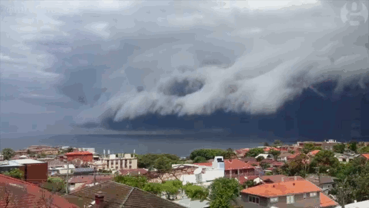
Shelf Cloud
Sydney, Australia was treated to a spectacular meteorological show over the weekend when an impressive shelf cloud swept over the city. These timelapses show the dramatic leading edge of the incoming thunderstorm. Notice how the cloud streams upward along the shelf. The storm is driven by this updraft of warm moist air, which rises until it is capped by the troposphere. At this point, the air spreads, creating an anvil-like shape, and cools. The moisture drawn up at the storm’s front will condense, freeze, and fall as rain or hail. When the updraft weakens, the storm will be dominated by the downdraft of the falling precipitation and eventually peter out. (Image credit: W. Reed and H. Vann, source; via J. Hertzberg)

Foggy Flows
The transparency of air makes it easy to overlook its fluid nature. In this National Geographic Travel Photographer of the Year entry, photographer Thierry Bornier captures the early morning view from China’s Yellow Mountain. Foggy clouds flow around and over nearby mountain peaks, like water flowing over rocks in a stream. To see other, similar effects, check out these timelapse videos of fog in the Grand Canyon and clouds around San Francisco. (Image credit: T. Bornier; via Colossal)

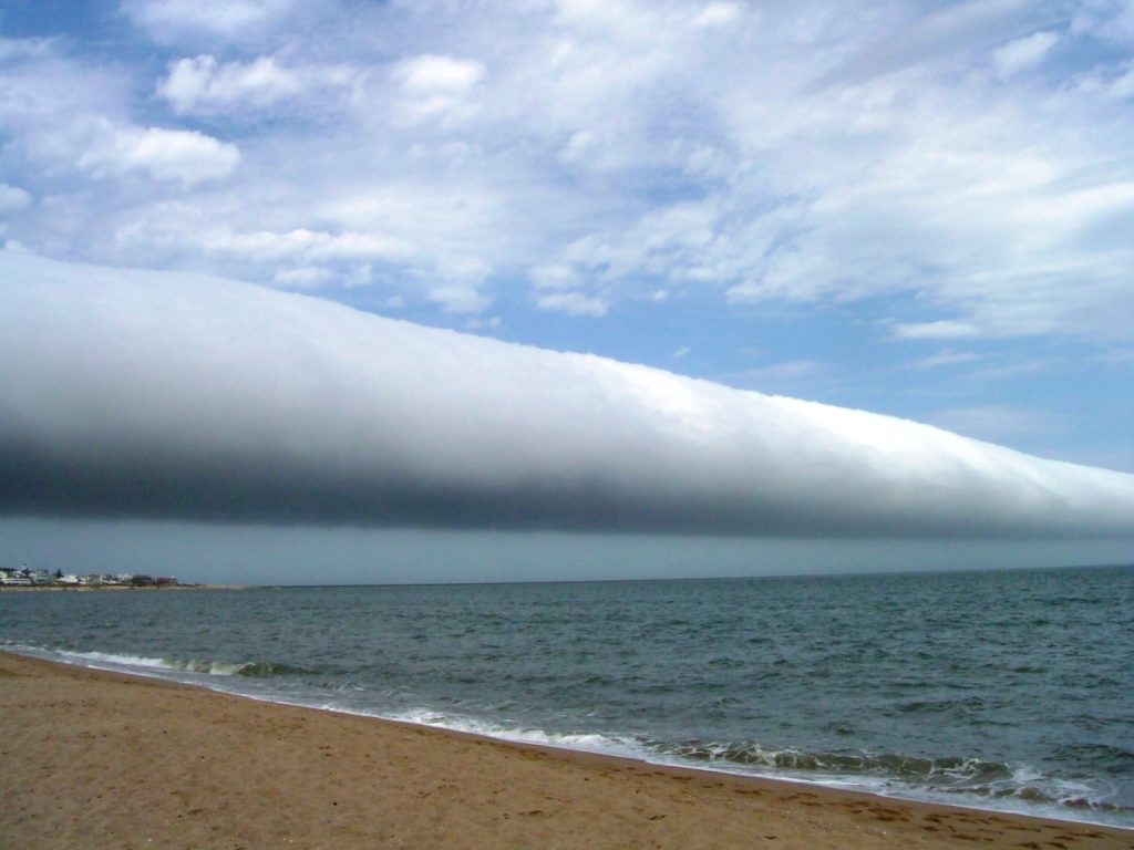
Roll Clouds

The roll cloud, or Morning Glory cloud, is a rare phenomenon that looks rather like a horizontal tornado. In reality, it is part of a soliton wave traveling through the atmosphere. At its leading edge, moist air is forced upward, causing water vapor to condense, and, at the trailing edge, air moves downward, dissipating the cloud. These clouds are most frequently observed in Australia near the Gulf of Carpentaria, where local geography and sea breezes promote their growth during springtime. The clouds do appear elsewhere on occasion; the photos above show rolls clouds in Calgary, Alberta and coastal Uruguay, respectively. (Image credits: G. E. Nyland, D. M. Eberl; see also: Z. Ouazzani)

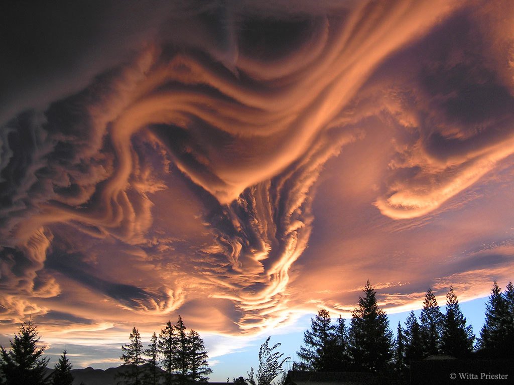
A New Cloud
These unusual and spectacular clouds are known as undulatus asperatus. Though they have been proposed as a new type of cloud, they are as yet officially unrecognized. Despite their dramatic appearance, these clouds are not associated with storms. Instead, they’re thought to form in a process similar to mammatus clouds, where wind shear at the cloud level causes undulations to form. This wave-like structure is especially visible in the photo above thanks to a low sun angle illuminating the underside of the clouds. (Image credit: W. Priester; via APOD)
Wave Clouds
In this video, Sixty Symbols tackles the physics of wave clouds. When air flows over an obstacle like a mountain, the air can begin to oscillate downstream, forming what is known as a lee wave. As the air bobs up and down, it will cool or warm according to its altitude. At cooler conditions, if the air is moist, it can condense into a cloud at the peak of its oscillation. If you observe this behavior over time, you get what appear to be regularly-spaced stripes of clouds. This is actually a pretty common phenomenon to see, depending on where you live. It’s an example of internal waves in the atmosphere. (Video credit: Sixty Symbols)
Do you enjoy FYFD and want to help support it? Then please considering becoming a patron!
Reminder: If you’re at the University of Illinois at Urbana-Champaign, I’m giving a seminar tomorrow afternoon. Not in Illinois? I’ve got other events coming up, too!
“Monsoon II”
Every child learns about the water cycle in school, but an academic description of the process often lacks nature’s grandeur. In “Monsoon II” photographer Mike Olbinski captures the majesty of cloud formation and rainfall in a way that rekindles awe for the scale of the process. It begins with bright clouds popping up, the result of warm moist air rising from the ground and cooling at altitude. As more water vapor evaporates, rises, and condenses, water droplets collide in these clouds, coalescing and growing until they grow too large and heavy to stay aloft. These are the droplets that fall in sheets of rain, blurring the air beneath them. There’s an incredible beauty to watching rain fall from a distance; it looks calm and localized in a way that’s utterly at odds with the experience from inside the storm. (Video credit: M. Olbinski; submitted by jshoer)
Waves Over the Rockies
These spectacular wave-like clouds are the result of the Kelvin-Helmholtz instability. When two layers of air move past one another at different velocities, an unstable shear layer forms at their interface. Disturbances in this shear layer grow exponentially, creating these short-lived overturning waves that quickly turn turbulent. The strong resemblance of these clouds to breaking ocean waves is no coincidence–the Kelvin-Helmholtz instability occurring between the wind and water is what generates many ocean waves. Kelvin-Helmholtz patterns are also common on other planets, like Jupiter, Saturn, and Mars. (Image credit: Breckenridge Resort; submitted by jshoer)


