Severe weather — like thunderstorms, tornadoes, and hurricanes — can push air upward into a higher layer of the atmosphere and trigger gravity waves. Aboard the International Space Station (ISS), the Atmospheric Waves Experiment (AWE) instrument captures these waves by looking for variations in the brightness of Earth’s airglow (above). Recently, when Hurricane Helene hit the southeastern United States, AWE caught a series of gravity waves some 55 miles up, pushed by the storm (below). It’s incredible to see these long-ranging ripples spreading far beyond the heart of the storm. (Video credits: NASA Goddard and Utah State University)
Category: Phenomena

Glacial Tributaries
Just as rivers have tributaries that feed their flow, small glaciers can flow as tributaries into larger ones. This astronaut photo shows Siachen Glacier and four of its tributaries coming together and continuing to flow from the top to the bottom of the image. The dark parallel lines running through the glaciers are moraines, where rocks and debris are carried along by the ice. Those seen here are medial moraines left by the joining of tributaries. When glaciers retreat, moraines are often left behind, strewn with sediment that ranges from the fine powder of glacial flour all the way to enormous boulders. (Image credit: NASA; via NASA Earth Observatory)
Fediverse Reactions
-

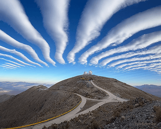
Wave Clouds in the Atacama
Striped clouds appear to converge over a mountaintop in this photo, but that’s an illusion. In reality, these clouds are parallel and periodic; it’s only the camera’s wide-angle lens that makes them appear to converge.
Wave clouds like these form when air gets pushed up and over topography, triggering an up-and-down oscillation (known as an internal wave) in the atmosphere. At the peak of the wave, cool moist air condenses water vapor into droplets that form clouds. As the air bobs back down and warms, the clouds evaporate, leaving behind a series of stripes. You can learn more about the physics behind these clouds here and here. (Image credit: Y. Beletsky; via APOD)
Fediverse Reactions
-

A Mini Jupiter
Astronaut Don Pettit posted this image of a Jupiter-like water globe he created on the International Space Station. In microgravity, surface tension reigns as the water’s supreme force, pulling the mixture of water and food coloring into a perfect sphere. It will be interesting to see a video version of this experiment, so that we can tell what tools Pettit used to swirl the droplet into the eddies we see. Is the full droplet rotating (as a planet would), or are we just seeing the remains of a wire passed through the drop? We’ll have to stay tuned to Pettit’s experiments to find out. (Image credit: NASA/D. Pettit; via space.com; submitted by J. Shoer)
Fediverse Reactions
-

Skydiving Salamanders


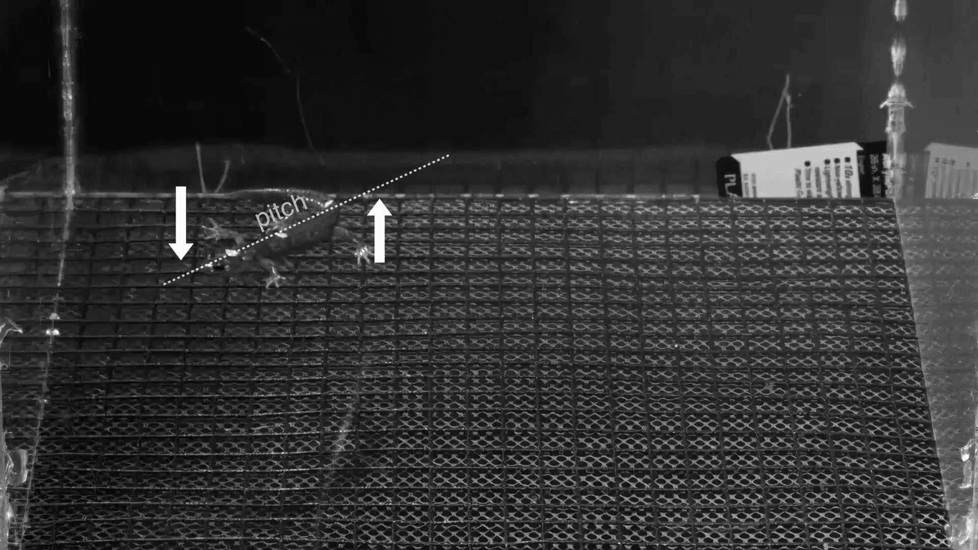

The wandering salamander can spend its entire 20-year lifespan in the canopy of a coast redwood. When predators come calling, they have a special skill that helps them get away: skydiving. These little amphibians have no webbed appendages and no wings, but they’re some of the most skillful skydivers out there. By carefully repositioning its tail and feet, a wandering salamander controls its pitch, yaw, and roll. It’s not only able to orient itself as it falls; it can actually steer itself to a safe landing! Other salamander species, as seen in the video above, do not share this skill. Check out the full Deep Look video to see these incredible gliders in action. (Video and image credit: Deep Look; see also C. Brown)

Predicting Droplet Sizes
Squeeze a bottle of cleaning spray, and the nozzle transforms a liquid jet into a spray of droplets. These droplets come in many sizes, and predicting them is difficult because the droplets’ size distribution depends on the details of how their parent liquid broke up. Shown above is a simplified experimental version of this, beginning with a jet of air striking a spherical water droplet on the far left. In less than 3 milliseconds, the droplet has flattened into a pancake shape. In another 4 milliseconds, the pancake has ballooned into a shape called a bag, made up of a thin, curved water sheet surrounded by a thicker rim. A mere 10 milliseconds after the jet and drop first meet, the liquid is now a spray of smaller droplets.
Researchers have found that the sizes of these final droplets depend on the balance between the airflow and the drop’s surface tension; these two factors determine how the drop breaks up, whether that’s rim first, bag first, or due to a collision between the bag and rim. (Image credit: I. Jackiw et al.; via APS Physics)

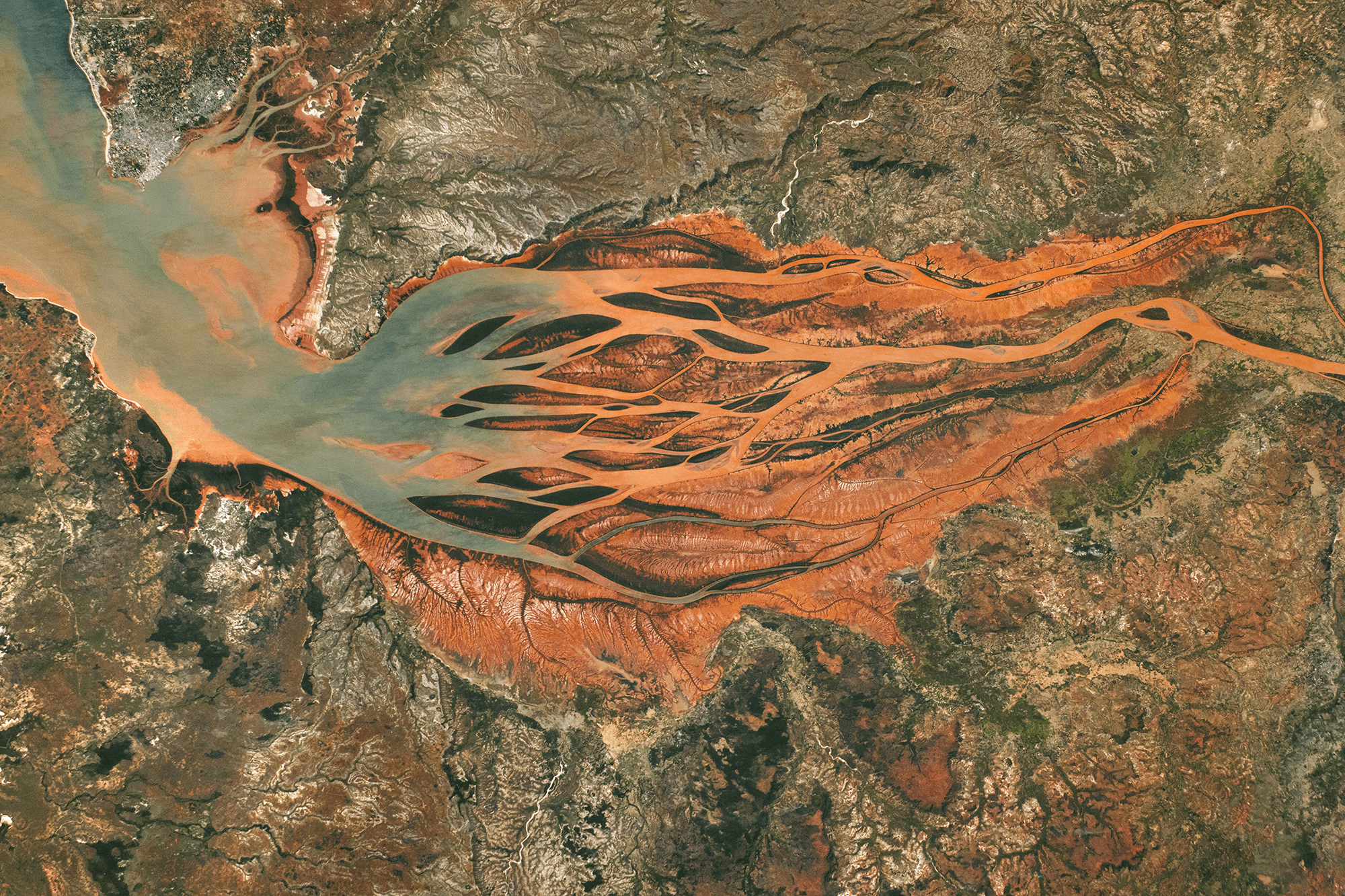
Growing Downstream
This astronaut photo shows Madagascar’s largest estuary, as of 2024. On the right side, the Betsiboka River flows northwest (right to left, in the image). Less than 100 years ago, most of the estuary was navigable by ships, but now more than half of it is taken up by the river delta. Upstream on the river, extensive logging and expansions to farmland have caused severe soil erosion; the river carries that sediment downstream, dyeing the waters reddish-orange. As the river branches and the flow slows, that sediment falls out of suspension, building up islands and seeding new sand bars further downstream.

A difference of 40 years. A 2024 astronaut photo of the Betsiboka River delta compared with one from 1984 (inset). Several islands are labeled in both images. Notice how new islands have formed upstream of the ones seen in 1984. In the image above, you can compare the 2024 delta to the way it looked in 1984. Letters A, B, C, and D mark the downstream-most islands from 1984. Today newer islands and sand bars sit even further downstream. (Image credit: NASA; via NASA Earth Observatory)
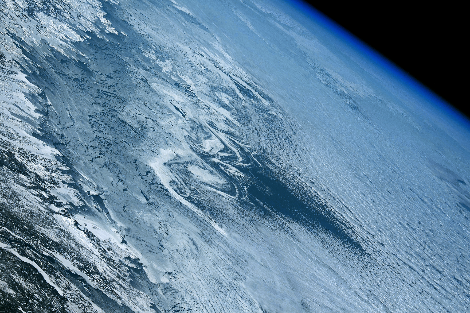
Lines of Ice Eddies
In February 2024, the North Atlantic’s sea ice reached its furthest extent of the season, limning the coastline with tens of kilometers of ice. These images — both capturing the Labrador coast on the same day — show the swirling patterns marking the wispy edges of ice field. In this region, the ice is likely following an eddy in the ocean below. Eddies like these can form along the edges where warm and cold currents meet. An ice eddy is particularly special, though, as the water must be warm enough to fragment the sea ice, but not so warm that it melts the smaller ice pieces. (Image credit: top – NASA, lower – M. Garrison; via NASA Earth Observatory)

This satellite image shows sea ice off the Labrador coast, on the same day in February 2024. Running Out of Sand?


Headlines over the past few years have suggested that the world is running out of sand — specifically, that we’re running out of the angular sand grains preferred for concrete. Grady breaks down this idea in this Practical Engineering video, showing that the issue is more complicated than the shape of a sand grain. Yes, angular sand grains make stronger concrete than rounded ones for the same ingredient ratios. But concrete’s water content is also a major factor for strength, and rounded sand grains need less water to form a spreadable, workable concrete. Using less water also makes for stronger concrete.
And though we may be short on some types of sand in certain places, sand is a manufacturable substance. We have machines and processes capable of breaking rocks into sand. It’s more a matter of choosing between the economics of mining and manufacturing. (Video and image credit: Practical Engineering)
The Taum Sauk Dam Failure and Its Legacy
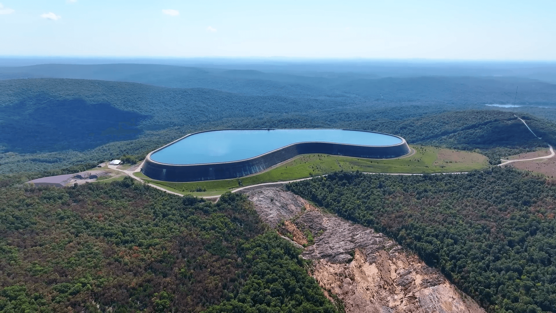


Managing an electrical grid is all about balancing the electricity that plants can supply with the instantaneous demands of consumers. If there’s more power available than people need, it needs to get stored somehow. And for decades, the best way to store that excess supply has been in hydroelectric reservoirs like at the Taum Sauk Dam. These facilities pump water to a reservoir at a higher elevation when there’s extra electrical power available, and, when more power is needed, release that water to run through hydroturbines.
But storing water atop a mountain comes with unusual challenges for dam, and the 2005 failure of the Taum Sauk Dam facility highlights some important lessons for engineers. As Grady lays out in this Practical Engineering video, there was no single mistake that led directly to the dam’s failure. Instead, post-collapse investigations found a series of seemingly minor issues that, together, led to catastrophe. It’s well worth watching, especially for engineers; we could all use an occasional reminder that a “quick stopgap measure” isn’t enough. (Video and image credit: Practical Engineering)