This Colorado supercell thunderstorm features an unusual twist. Notice the sawtooth-like protrusions along the outer cloud wall. These are Kelvin-Helmholtz waves, like these fair-weather clouds we’ve seen before, but instead of occurring vertically, they project horizontally! That implies that the invisible layer of air just outside the cloud wall is moving faster than the wall itself. That creates shear along the outer edge of the cloud wall and causes these waves to form. This is the first time I’ve ever seen this sort of thing. What an awesome photo! (Image credit: M. Charnick; submitted by jpshoer)
Tag: supercell

“Breathe”


In black and white, the towering power of a thunderstorm looks almost apocalyptic. Photographer Mike Olbinski’s latest storm timelapse, “Breathe,” features roiling turbulence, distant downpours, and eerie mammatus clouds. Supercell thunderstorms churn and rotate over empty horizons. Billowing cumulus clouds condense from bright skies. Flashes of lightning reveal the outlines of massive thunderheads. It’s a beautiful glimpse of atmospheric fluid dynamics in action, with every texture magnified and enhanced by the stark black and white palette. (Video and image credit: M. Olbinski; via Gizmodo)
“Pursuit”
Photographer Mike Olbinski has released yet another breathtaking timelapse film of weather over the Great Plains. This one has a little bit of everything: storms, tornadoes, incredible cloud formations, and even sunny days. Olbinski’s work is a reminder that there’s a constant beautiful drama playing out over our heads if we just take the time to watch. Under blue skies, condensation and turbulence are building towering mountains, and even when the sky is gray, it can be churning like the ocean just over your head. The U.S. Great Plains may be home to particularly dramatic examples of this behavior (thanks largely to the atmospheric influence of the Rocky Mountains), but these same phenomena are going on all the time overhead. (Video and image credits: M. Olbinski)

“Fractal”
Timelapses are a wonderful way to capture the power and majesty of storms like the supercell thunderstorms featured in Chad Cowan’s “Fractal”. The video contains snapshots from six years’ worth of storms over the US’s Great Plains. The highlights include some spectacular mammatus clouds (0:30) and excellent billowing cloud formation (1:27) with turbulence every bit as towering as that of a volcanic plume. June is one of the best months for amazing storms in the Great Plains, largely thanks to the atmospheric mixing that occurs over the Rocky Mountains. If you have the opportunity to witness these amazing natural displays, enjoy it, but be safe! (Video credit: C. Cowan; image via Colossal)


Simulating Thunderstorms
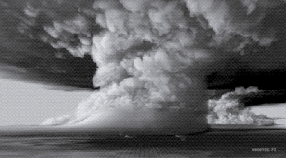
With today’s supercomputing power, it’s possible to simulate entire thunderstorms to study how and why some of them can spawn deadly tornadoes. The animation above comes from a computer simulation of a supercell thunderstorm. The simulation uses initial conditions from a 2011 storm that produced an EF-5 tornado – the highest category of tornado, based on its wind speeds. To see more of the simulation, check out the video below. One thing that might surprise you is just how enormous the towering supercell clouds are compared to the tornado produced in the simulation. Often what we can see of a storm from the ground is only the tiniest part of what goes into producing it. (Image credit: L. Orf et al., source; GIF via @popsci; video credit: UWSSEC)
“Pulse”
Photographer Mike Olbinski returns with another incredible storm-chasing timelapse video, this time all in black-and-white. To me, that choice helps “Pulse” emphasize the ominous majesty of these supercells and tornadoes by highlighting the textures that make up the clouds. Watching clouds in timelapse, they seem to materialize from nowhere as moisture drawn up from the land cools and condenses. Sped up, suddenly the convective rotation and the roiling turbulence inside clouds is perfectly clear. I especially love the sequence beginning at 2:25, where a distant black line slowly transforms into an incredible landscape marked with successive waves of rolling, turbulent clouds. Watch this one on a large screen at a high resolution, if you can. You won’t regret it! (Video credit: M. Olbinski)
“The Chase”
Sometimes it takes timelapse photography to truly appreciate the dynamic behavior of our atmosphere. In “The Chase” Mike Olbinski, whose work we’ve featured previously, has captured some of the most incredible and stunning weather timelapse footage I have ever seen. Despite watching it repeatedly, I continue to be awed to the point that I have no words. Seriously, just watch it. Be amazed by the drama of our sky. (Video credit: M. Olbinski)
Supercell Timelapse
The storm chasing group Basehunters captured this stunning timelapse of a supercell thunderstorm forming in Wyoming. This class of storm is characterized by the presence of a mesocyclone, seen here as a large, rotating cloud. These rotating features form when horizontal wind shear is redirected upright by an updraft. This requires a strong updraft, which is often formed by a capping inversion, where a layer of warm air traps colder air beneath it. Supercells can be very dangerous in their own right, releasing torrential rains and large hail, but they are also capable of spawning violent tornadoes. (Video credit: Basehunters; via Bad Astronomy; submitted by jshoer)
Supercell Thunderstorm
Photographer Mike Olbinski has captured a spectacular timelapse of a supercell thunderstorm over the plains of Texas. Supercells are characterized by a strong, rotating updraft known as a mesocyclone, seen clearly in the video. These storms are commonly isolated occurrences, forming when horizontal vorticity in the form of wind shear is redirected upwards by an updraft. Such a strong updraft is typically created by a capping inversion, a situation where a layer of warmer air traps the colder air beneath it. (This is why one sees a distinctive cut-off at the top of some clouds.) As warm air rises from the surface, either the air above the cap will cool or the air below the cap will warm. Either situation results in an instability with cooler air on top of warmer air, providing a catalyst for the kind of dramatic weather seen here. (Video credit: M. Olbinski; via io9)

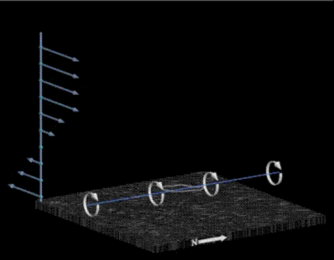
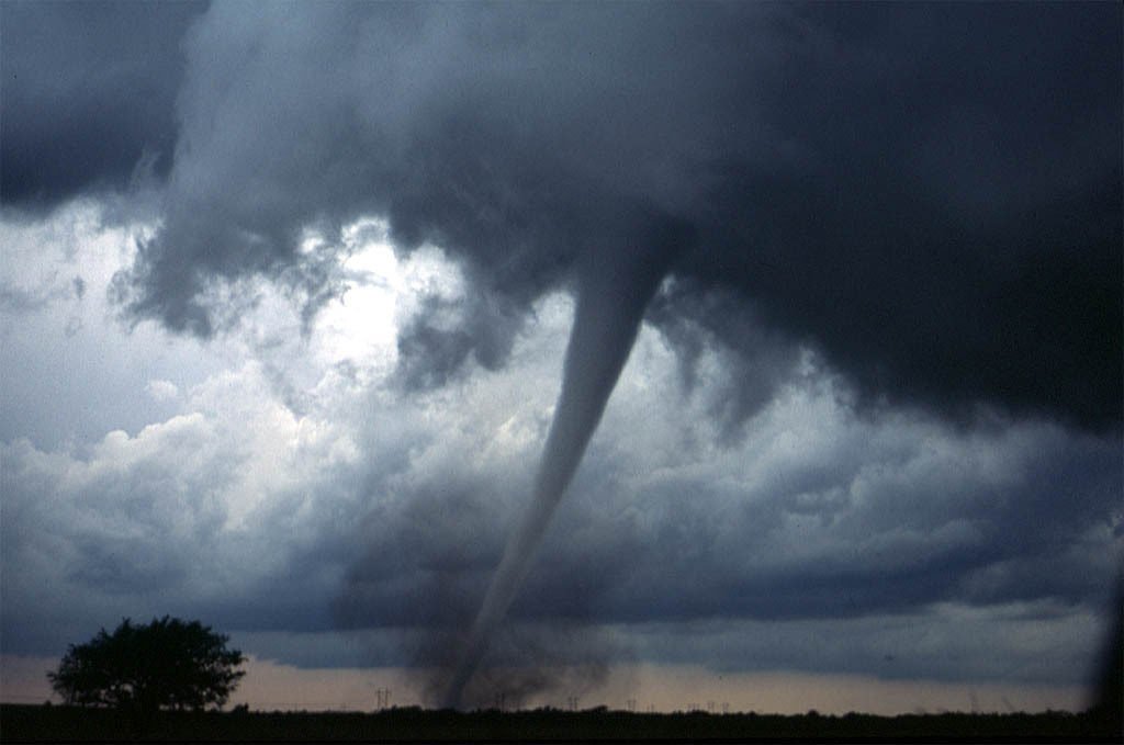
Tornadogenesis

Tornadogenesis–the formation of tornadoes–remains a topic of active research as there is relatively little direct experimental data, owing to the difficulty of prediction as well as measurement. Initially, a variation of wind speed at different altitudes in the atmosphere causes shearing, which can lead to the formation of a horizontal column of rotating air–a vortex line similar to a roll cloud. Beneath a developing storm, the updraft of warm local air can pull this vortex line upwards, creating vertical rotation in the cloud, thereby birthing a supercell. Supercells do not always spawn tornadoes, and the exact causes that result in tornadic or nontornadic supercells are not fully understood. However, the formation of tornadoes within the supercell seems dependent on the downdraft of cool air within the storm as well as stretching of the vortex line, which increases its rate of rotation. For more information, check out this explanatory video and some of the talks by Paul Markowski. (Thanks to mindscrib, aggieastronaut and others for their submissions related to this topic! Photo credits: P. Markowski and D. Zaras)