Tag: rain

  • Featured Video Play Icon

    “Monsoon IV”

    It’s a cliché to claim that the sky is bigger in the American West, but the wide, open views in that region do offer a very different perspective on weather. Photographer Mike Olbinski’s works give viewers a taste of that perspective of far-off thunderstorms, towering anvil clouds, and massive downpours in the distance. At the same time, many of his sequences illustrate the birth and death of these massive storms. As warm, moist air rises, a puffy cumulus cloud (below) swells upward as fresh moisture condenses. When it reaches a thermal cap and can rise no further, precipitation begins to fall, dragging surrounding air with it. This is the mature stage of a storm, when both updrafts and downdrafts exist simultaneously.

    Eventually, the storm’s power begins to wane as the downdrafts cut off the updrafts that feed the storm. Sometimes this occurs in a massive downdraft where cool air sinks straight down and, upon encountering the ground, spreads radially outward. In dry regions, this outward burst of ground-level winds can pick up dirt, dust, and sand, forming a wall-like haboob (below) that advances past the remains of the storm. Watch the entire video to see some examples in their full glory! (Video and image credit: M. Olbinski, source; via Rex W.)

    image
  • Creating Clouds

    Creating Clouds

    Despite their ubiquity and importance, we know surprisingly little about how clouds form. The broad strokes of the process are known, but the details remain somewhat fuzzy. One challenge is understanding how nucleation – the formation of droplets that become clouds or rain – works. A recent laboratory experiment in an analog cloud chamber suggests that falling rain drops may help spawn more rain drops.

    The experiment takes place in a chamber filled with sulfur hexafluoride and helium. The former acts like water in our atmosphere, appearing in both liquid and vapor forms, while the latter takes the place of dry components of our atmosphere, like nitrogen. The bottom of the chamber is heated, forming a liquid layer of sulfur hexafluoride, seen at the bottom of the animation above. The top of the chamber is cooled, encouraging sulfur hexafluoride vapor to condense and form droplets that fall like rain. A top view of the same apparatus during a different experiment is shown in this previous post.

    When droplets fall through the chamber, their wakes mix cold vapor from near the drop with warmer, ambient vapor. This changes the temperature and saturation conditions nearby and kicks off the formation of microdroplets. These are the cloud of tiny black dots seen above. Under the right conditions, these microdroplets grow swiftly as more vapor condenses onto them. In time, they grow heavy enough to fall as rain drops of their own. (Image credits: P. Prabhakaran et al.; via APS Physics; submitted by Kam-Yung Soh)

  • How Rainfall Can Spread Pathogens

    How Rainfall Can Spread Pathogens

    Rainfall may provide a mechanism for soil bacteria to spread. A new study examines how raindrops hitting infected soil can eject bacteria into the air. When drops fall at the rate of a light rainfall, they form tiny bubbles after impact (upper left). Those microbubbles rise to the top of the water and burst, sending extremely tiny droplets – or aerosols – spraying up into the air (upper right). Soil bacteria can hitch a ride on these aerosols, staying alive for up to an hour while the wind transports them to fresh, new soil. The researchers found that the most aerosols were produced when soil temperature was about 86 degrees Fahrenheit (30 degrees Celsius) – the temperature of tropical soils. Depending on the conditions, a single raindrop could aerosolize anything from zero to several thousands of soil bacteria. (Image and research credit: Y. Joung et al.; video credit: MIT News)

  • Creating Clouds

    Creating Clouds

    What you see here is the formation of clouds and rain – but it’s not quite what you’re used to seeing outside. This is an experiment using a mixture of sulfur hexafluoride and helium to create clouds in a laboratory. Everything is contained in a cell between two transparent plates. Liquid sulfur hexafluoride takes up about half of the cell, and when the lower plate is heated, that liquid begins evaporating and rising in the bright regions. When it reaches the cooled top plate, the liquid condenses into droplets inside the dimples on the plate, eventually growing large enough to fall back as rain. The dark wisps you see are areas where cold sulfur hexafluoride is sinking, much like in the water clouds we are used to. Setups like this one allow scientists to study the effects of turbulence on cloud physics and the formation of droplets. (Image credit: E. Bodenschatz et al., source)

    Boston-area folks! I’ll be taking part in the Improbable Research show Saturday evening at 8 pm at the Sheraton Boston. Come hear about the Boston Molasses Flood and other bizarre research!

  • Featured Video Play Icon

    Microburst

    Earlier this week a Columbus, OH TV station tower camera caught this awesome timelapse footage of several microbursts in a thunderstorm. A microburst is a sudden, localized downdraft inside the storm. You can see a clear microburst starting at about 0:30 seconds. Note how it flares up and out as it hits the ground, eventually settling around the time a rainbow appears on the left edge of the frame. These strong winds moving down then curling out can be dangerous, both to structures on the ground and to any aircraft unfortunate enough to be taking off or landing in the storm. (Video credit: WCMH; submitted by
    A. Bcstractor)

  • Featured Video Play Icon

    “Monsoon II”

    Every child learns about the water cycle in school, but an academic description of the process often lacks nature’s grandeur. In “Monsoon II” photographer Mike Olbinski captures the majesty of cloud formation and rainfall in a way that rekindles awe for the scale of the process. It begins with bright clouds popping up, the result of warm moist air rising from the ground and cooling at altitude. As more water vapor evaporates, rises, and condenses, water droplets collide in these clouds, coalescing and growing until they grow too large and heavy to stay aloft. These are the droplets that fall in sheets of rain, blurring the air beneath them. There’s an incredible beauty to watching rain fall from a distance; it looks calm and localized in a way that’s utterly at odds with the experience from inside the storm. (Video credit: M. Olbinski; submitted by jshoer)

  • Reader Question: Rippling Runoff

    Reader Question: Rippling Runoff

    Reader junolivi asks:

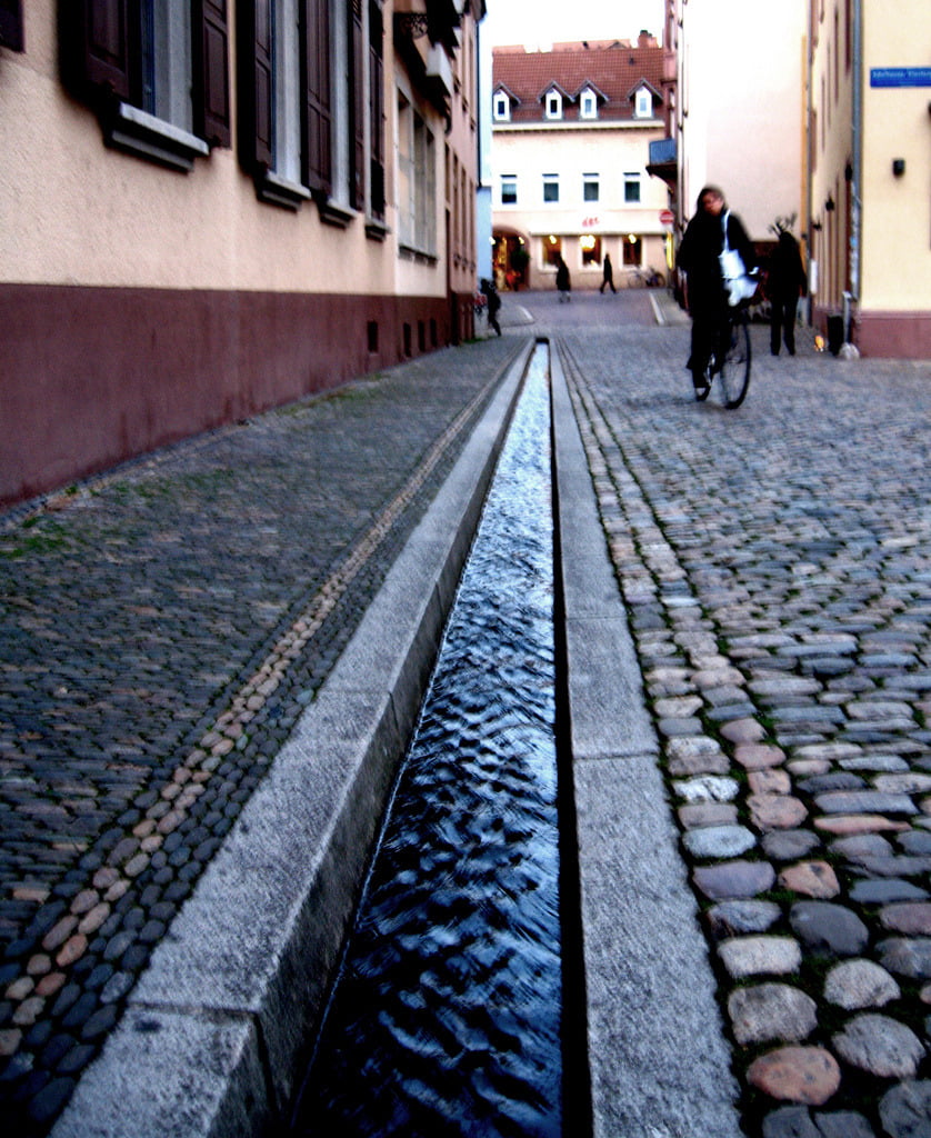
    When shallow water (like runoff from melting snow) flows across pavement, it creates small repeated wave-like ripples. What creates that texture and why isn’t it just a steady flow?

    This is a great question that’s probably crossed the mind of anyone who’s seen water running down the gutter of a street after a storm. The short answer is that this gravity-driven flow is becoming unstable.

    Fluid dynamicists often like to characterize flows into two main types: laminar and turbulent. Most flows in nature are turbulent, like the wild swirls you see behind cars driving in the rain. But there are laminar flows in nature as well. Often flows that begin as laminar will become turbulent. This happens because those laminar flows are unstable to disturbances.

    The classic example of stability is a ball on a hill. If the ball is at the top of the hill and you disturb it, it will roll down the hill because its original position was unstable. If, on the other hand, the ball is in a depression, then you can prod the ball and it will eventually settle back down into its original place because that position was stable. Another way of looking at it is that, in the unstable case, the disturbance–how far the ball is from its original position–grows uncontrollably. In the stable case, on the other hand, the disturbance can be initially large but eventually decays away to nothing.

    There are many ways to disturb a laminar flow–surface roughness, vibrations, curvature, noise, etc., etc. These disturbances enter the flow and they can either grow (and become unstable) or decay (because the flow is stable to the disturbance). Just as one can look at the stability of a pendulum, one can mathematically examine the stability of a fluid flow. When one does this for water flowing down an incline, one finds that the flow is quite unstable, even in the ideal case of a pure, inviscid fluid flowing down a smooth wall.

    The reason that one sees distinctive waves with a particular wavelength (assuming that they aren’t caused by local obstructions) is directly related to this idea of instability. Essentially, the waves are the disturbance, having grown large enough to see. One could imagine that any wavelength disturbance is possible in a flow, but mathematically, what one finds, is that different wavelengths have different growth rates associated with them. The wavelength we observe is the most unstable wavelength in the flow. This is the wavelength that grows so much quicker than the others that it just overwhelms them and trips the flow to turbulence. This is very common. For example, you can see distinctive waves showing up before the flow goes turbulent in both this mixing layer simulation and this boundary layer flow.

    (Image credits: anataman, mo_cosmo; also special thanks to Garth G. who originally asked a similar question via email)

  • Featured Video Play Icon

    How Rain Gets Its Smell

    Light rain after a dry spell often produces a distinctive earthy scent called petrichor that is associated with plant oils and bacteria products. How these chemicals get into the air has been unclear, but new research suggests that the mechanism may come from the rain itself. When water falls on a porous surface like soil, tiny air bubbles get trapped beneath the drop. These bubbles rise rapidly due to buoyancy and, upon reaching the surface, burst and release tiny droplets known as aerosols. Depending on the surface properties and the drop’s impact speed, a single drop can produce a cloud of aerosol droplets. The research team is now investigating how readily bacteria or pathogens in the soil can spread through this mechanism. Other human-focused research has already shown that these tiny aerosol droplets can persist in the air for remarkably long periods and may help spread diseases. (Video credit: Massachusetts Institute of Technology; research credit: Y. Joung and C. Buie; submitted by Daniel B and entropy-perturbation)

  • The Real Shape of Raindrops

    The Real Shape of Raindrops

    We often think of raindrops as spherical or tear-shaped, but, in reality, a falling droplet’s shape can be much more complicated. Large drops are likely to break up into smaller droplets before reaching the ground. This process is shown in the collage above. The initially spherical drops on the left are exposed to a continuous horizontal jet of air, similar to the situation they would experience if falling at terminal velocity. The drops first flatten into a pancake, then billow into a shape called a bag. The bags consists of a thin liquid sheet with a thicker rim of fluid around the edge. Like a soap bubble, a bag’s surface sheet ruptures quickly, producing a spray of fine droplets as surface tension pulls the damaged sheet apart. The thicker rim survives slightly longer until the Plateau-Rayleigh instability breaks it into droplets as well. (Image credit: V. Kulkarni and P. Sojka)

  • The Real Raindrop

    The Real Raindrop

    What is the shape of a falling raindrop? Surface tension keeps only the smallest drops spherical as they fall; larger drops will tend to flatten. The very largest drops stretch and inflate with air as they fall, as shown in the image above. This shape is known as a bag and consists of a thin shell of water with a thicker rim at the bottom. As the bag grows, its shell thins until it ruptures, just like a soap bubble. The rim left behind destabilizes due to the surface-tension-driven Plateau-Rayleigh instability and eventually breaks up into smaller droplets. This bag instability limits the size of raindrops and breaks large drops into a multitude of smaller ones. The initial size of the drop in the image was 12 mm, falling with a velocity of 7.5 m/s. The interval between each image is 1 ms. (Photo credit: E. Reyssat et al.)