Tag: geophysics

  • Bubbles Affect Lava Flow

    Bubbles Affect Lava Flow

    During the 2018 eruption at Kilauea, scientists noticed that the lava flowed very differently depending on how bubbly it was. In this experiment, researchers used corn syrup as a lava analogue and studied how bubbly and particle-filled bubbly flows differed from bubble-free ones. They found that bubble-free syrup flowed fastest, while particle-filled bubbly flows were by far the slowest.

    The bubbles also affected the structure of the flows. Large bubbles gathered near the surface of the flow’s leading edge, allowing faster flow beneath. And in the particle-filled flow, the corn syrup developed channels that flowed at different speeds. The authors hope that their relatively simple experimental set-up will inspire more research on bubbly lava flows. (Image and research credit: A. Namiki et al.; via AGU Eos; submitted by Kam-Yung Soh)

  • Rocking From The Waves

    Rocking From The Waves

    Not all seismic activity stems from earthquakes. In fact, much of Earth’s measured seismic waves come from interactions of the ocean and atmosphere with solid ground. Some of the strongest vibrations come from interactions of ocean waves, which transmit pressure waves that don’t attenuate with depth before passing into the solid Earth.

    How those waves propagate and scatter inside the Earth has been a matter of contention for decades, but recent simulations are beginning to uncover the mechanisms that lead to the waves seismologists measure. (Image credit: I. Mingazova; via Physics Today)

  • Following the Flow

    Following the Flow

    In early December 2020, the world’s largest iceberg — roughly 135 km long by 44 km wide — was heading straight for South Georgia Island. Luckily for the island, iceberg A-68A was being carried by ocean surface currents that approach the island before turning sharply southward. The enormous iceberg followed, rotating nearly 90 degrees and drifting away on faster currents.

    Scientists track these large-scale — 50 to 100 km wide — currents using satellites that measure the ocean height. Currents of this size actually generate a measurable tilt to the ocean surface, which scientists measure and use as input into models that estimate the surface currents’ speed and direction. (Image credit: L. Dauphin and J. Stevens; via NASA Earth Observatory)

  • Uncovering Erosion Patterns

    Uncovering Erosion Patterns

    Gypsum and limestone cliffs sometimes form patterns of long, parallel grooves known as rillenkarren. Recent research shows that these patterns form when a thin layer of water flows over a dissolvable surface. As the running water picks up solute, its concentration increases, causing changes in the local hydrodynamics. What begins as a small perturbation in an otherwise flat surface grows into a groove with walls that eventually rise out of the water layer. At that point, the growth mechanism shifts because the flow is restricted to channels in the rock. (Image credit: Ymaup/Wikimedia Commons; research credit: A. Guérin et al.; via APS Physics; submitted by Kam-Yung Soh)

  • The Undisturbed Waters of Lake Kivu

    The Undisturbed Waters of Lake Kivu

    Deep in Africa lies one of the world’s strangest lakes. Lake Kivu, over 450 meters in depth, is so stratified that its layers never mix. The upper portion of Lake Kivu consists of less-dense fresh water, which sits upon deeper layers of saltier water full of dissolved carbon dioxide and methane pumped into the lake by volcanic activity.

    The lake’s lack of convection means that this deep water simply stays put for thousands of years as it collects gases that remain dissolved only thanks to the immense pressure of the water above. Should that deep water be disturbed — by an earthquake, climate changes, or simply oversaturation — the resulting eruption of carbon dioxide could be deadly for the millions of people living nearby. A similar eruption at smaller Lake Nyos in 1986 asphyxiated about 1,800 people.

    Fortunately, Lake Kivu is well-monitored, so such an upwelling should not catch observers off-guard. Learn more about Lake Kivu’s oddities over at Knowable. (Image and research credit: D. Bouffard and A. Wüest, via Knowable Magazine; submitted by Kam-Yung Soh)

  • A Colorful Portrait of Flow

    A Colorful Portrait of Flow

    This gorgeous, natural-color image shows Lake Balkhash in southeastern Kazakhstan. In early March, the ice on the lake was beginning to break up, revealing glimpses of swirling sediment below the water’s surface. In contrast, the smaller lakes and ponds of the surrounding area remained frozen amidst the wintery browns of the nearby desert and wetlands. (Image credit: J. Stevens/USGS; via NASA Earth Observatory)

  • Stratospheric Effects of Wildfires

    Stratospheric Effects of Wildfires

    Australia’s bushfires from earlier this year are offering new insights into how pyrocumulonimbus clouds can affect our stratosphere. A massive, uncontrolled blaze between December 29th and January 4th generated a towering, turbulent cloud of smoke like the one shown above.

    Using meteorological data, a new study shows this enormous cloud initially rose to 16 km in altitude, then began a months-long trek that circled the globe. The smoke plume ultimately stretched to over 1,000 km wide and reached a record altitude of over 31 km. Inside the plume, concentrations of water vapor and carbon monoxide were several hundred percent higher than normal stratospheric air.

    Researchers found the plume extremely slow to dissipate, possibly due to strong rotational winds surrounding it. This is the first time scientists have observed these shielding winds, and work is still underway to determine how and why they formed. (Image credit: M. Macleod/Wikimedia Commons; research credit: G. Kablick III et al.; via Science News; submitted by Kam-Yung Soh)

  • Featured Video Play Icon

    Centrifugal Instability

    When it comes to geophysics, there are all kinds of phenomena that depend on rotation. In this short video, researchers demonstrate one such phenomena — the centrifugal instability — in a tank on a turn table. The experiment begins once the fluid in the tank is all rotating together, like a solid body would. Then, they reduce the rotation rate of the turn table. Almost immediately, we see rolls encircle the tank.

    The rolls form due to the difference in momentum between fluid in the interior and near the wall. Friction with the wall slows the fluid there down much faster than that in the middle of the tank. As the faster-moving fluid gets centrifuged outward, it forms rolls. As the video demonstrates, these rolls can be relatively uniform and laminar, or, with enough change in rotation rate, they can become turbulent. (Image and video credit: UCLA Spinlab)

  • Internal Waves in the Andaman Sea

    Internal Waves in the Andaman Sea

    Differences in temperature and salinity create distinct layers within the ocean. When combined with flow over submerged topography — underwater canyons, mountains, and reefs — it makes waves. But those waves aren’t always apparent when sitting at the surface. Instead, they travel along those ocean layers as internal waves that can be as tall as hundreds of meters in height.

    When the sun glints just right off the ocean, these massive internal waves can be caught by satellite imagery, as shown in the above image of the Andaman Sea near Thailand and Myanmar. Even seemingly calm waters can roil in the deep. (Image credit: USGS; via NASA Earth Observatory)

  • Unifying Sediment Transport Theory

    Unifying Sediment Transport Theory

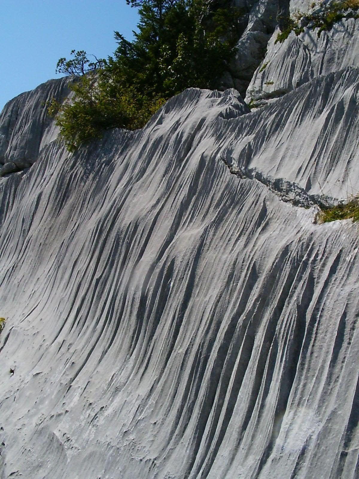
    On windy days, streaks of snowflakes snake in the air above a mountaintop snowfield. And when snorkeling in the surf, you can watch the inbound waves sculpt underwater ripples in the sand. Both are examples of sediment transport, and scientists have struggled to understand why the physics of these grains seems to differ between air and water. We observe certain behaviors, like saltation, in air and very different behaviors for grains underwater.

    One of the key differences is how much erosion occurs for a given amount of shear. In air, the relationship is linear; double the shear stress and you double the sediment transport rate. But in water, the relationship is nonlinear, meaning a small change in the shear stress can have a much larger effect on the rate of transport.

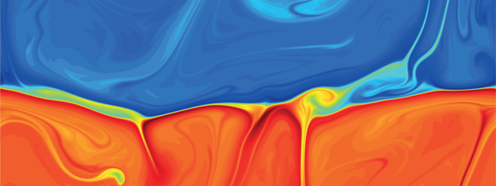
    A new study suggests that these differences are really only skin deep. Through detailed simulations, the researchers showed that what really matters is the energy dissipation caused by collisions between grains. Whether the medium is air or water, there are two important regions in the flow: the bed region where particles experience little movement, and the overlying region where grains are energized and lifted by the flow. In this framework, the researchers found no difference in how energy is dissipated, regardless of the medium.

    So why do measured sediment transport rates vary between air and water? The authors concluded that the relationship between shear and transport rate is, indeed, nonlinear. It’s just that the wind here on Earth is too weak to reach that nonlinearity. (Image credit: snow – wisconsinpictures, sand – J. Chavez; research credit: T. Pähtz and O. Durán; via APS Physics; submitted by Kam-Yung Soh)