Tag: geophysics

  • Internal Waves in the Andaman Sea

    Internal Waves in the Andaman Sea

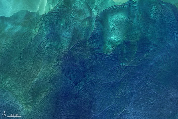
    Differences in temperature and salinity create distinct layers within the ocean. When combined with flow over submerged topography — underwater canyons, mountains, and reefs — it makes waves. But those waves aren’t always apparent when sitting at the surface. Instead, they travel along those ocean layers as internal waves that can be as tall as hundreds of meters in height.

    When the sun glints just right off the ocean, these massive internal waves can be caught by satellite imagery, as shown in the above image of the Andaman Sea near Thailand and Myanmar. Even seemingly calm waters can roil in the deep. (Image credit: USGS; via NASA Earth Observatory)

  • Unifying Sediment Transport Theory

    Unifying Sediment Transport Theory

    On windy days, streaks of snowflakes snake in the air above a mountaintop snowfield. And when snorkeling in the surf, you can watch the inbound waves sculpt underwater ripples in the sand. Both are examples of sediment transport, and scientists have struggled to understand why the physics of these grains seems to differ between air and water. We observe certain behaviors, like saltation, in air and very different behaviors for grains underwater.

    One of the key differences is how much erosion occurs for a given amount of shear. In air, the relationship is linear; double the shear stress and you double the sediment transport rate. But in water, the relationship is nonlinear, meaning a small change in the shear stress can have a much larger effect on the rate of transport.

    A new study suggests that these differences are really only skin deep. Through detailed simulations, the researchers showed that what really matters is the energy dissipation caused by collisions between grains. Whether the medium is air or water, there are two important regions in the flow: the bed region where particles experience little movement, and the overlying region where grains are energized and lifted by the flow. In this framework, the researchers found no difference in how energy is dissipated, regardless of the medium.

    So why do measured sediment transport rates vary between air and water? The authors concluded that the relationship between shear and transport rate is, indeed, nonlinear. It’s just that the wind here on Earth is too weak to reach that nonlinearity. (Image credit: snow – wisconsinpictures, sand – J. Chavez; research credit: T. Pähtz and O. Durán; via APS Physics; submitted by Kam-Yung Soh)
  • Eroding Ice

    Eroding Ice

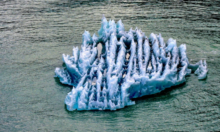
    When glaciers form, they do so in layers, with clear blue ice sandwiched between sediment and air-bubble-filled white ice. Because each of these layers absorbs sunlight differently, they don’t melt evenly. The spikes and ridges seen in this ice formed because of this differential melting between layers. The blue ice is particularly good at absorbing visible wavelengths of light, and so erodes more easily than the other layers.

    Although the results look somewhat similar to the penitente ice seen at high altitudes, the formation mechanisms are a little different. Penitentes rely heavily on sublimation — where their ice and snow change directly into a gas — rather than the melting seen here. That said, both eroded forms depend strongly on how different layers within them absorb and scatter sunlight. (Image credit: J. Van Gundy; via EPOD; submitted by Kam-Yung Soh)

  • Dunes Avoid Collisions

    Dunes Avoid Collisions

    The speed at which a dune migrates depends on its size; smaller dunes move faster than larger ones. That speed differential implies that small dunes should frequently collide into and merge with larger dunes, eventually forming one giant dune rather than a field of smaller separate ones. But that’s not what we observe in nature.

    To figure out why dunes aren’t colliding that often, researchers built a dune field of their own in the form of a rotating water tank. Inside the tank, their two artificial dunes can chase one another indefinitely while the researchers observe their interactions. What they found is that the dunes “communicate” with one another through the flow.

    As flow moves over the upstream dune, it generates turbulence in its wake, which the downstream dune then encounters. All that extra turbulence affects how sediment is picked up and transported for the downstream dune, ultimately changing its migration speed. For two dunes of initially equal size and close spacing, these interactions push the downstream dune further away until the separation between the dunes is large enough that they both migrate at the same speed. Even between dunes of unequal sizes, the researchers found that these repulsive interactions force the dunes away from collision and into migration at the same speed. (Image credit: dune field – G. Montani, others – K. Bacik et al.; research credit: K. Bacik et al.; via Cosmos; submitted by Kam-Yung Soh)

  • Submarine Canyons Focus Waves

    Submarine Canyons Focus Waves

    In winter months Toyama Bay in Japan can get hammered by waves nearly 10 meters in height. These waves, known as YoriMawari-nami, pose dangers to both infrastructure and citizens, and, thus far, are not captured by typical forecasting models.

    A new study indicates that these waves have their origin in the particular topography of Toyama Bay and the physics behind the double-slit experiment. The shape of Toyama Bay is such that only waves from the north-northeast can propagate all the way to shore. That restriction essentially creates a single, coherent source for waves in the bay.

    The bay is also home to submarine canyons that stretch like underwater valleys from the continental shelf down toward the deeper ocean. To the incoming waves, these canyons act much like the slits in the double-slit experiment, creating two sets of waves whose fronts can interfere. In some positions, a wave crest will combine with a wave trough, cancelling one another out. But in other spots, two wave crests will meet and combine, creating the much larger YoriMawari-nami wave.

    Diagram illustrating the similarity of the YM-wave phenomenon to Young's double-slit experiment. By H. Tamura et al.

    Toyama Bay is not the only spot in the world where this phenomenon happens. The same physics is behind some of the most popular surf spots in the world, including Half-Moon Bay in California and Nazaré, Portugal. In all of these cases, properly predicting wave heights requires tracking an extra variable — wave phase — that most models leave out. That’s why forecasters have struggled with Toyama Bay’s waves. (Image credit: wave – M. Kawai, diagram – H. Tamura et al.; research credit: H. Tamura et al.; via AGU Eos; submitted by Kam-Yung Soh)
  • Ice Rings Caused By Underlying Eddies

    Ice Rings Caused By Underlying Eddies

    Observations of strange ice rings on Lake Baikal, the world’s deepest lake, have puzzled scientists for decades. Surveys of satellite imagery have revealed rings on Baikal and two other lakes dating back to the 1960s and some of our earliest satellite images. The rings are roughly 5-7 km in diameter, with a dark layer of thin ice about 1 km wide around a brighter layer of thick ice.

    A new study, buoyed in part by on-the-ground observations during Siberian winter, argues that the ice rings observed on the surface are related to eddies of warmer water circulating below. The researchers were able to capture several eddies in their measurements, including one migratory one. The size, shape, and location of these sub-surface eddies are consistent with ice ring appearance. The kilometers’ wide eddies are several degrees warmer at shallow depths and rotate approximately once every 3 days.

    The researchers suspect the eddies form long before the ice does. Infrared observations in late autumn suggest the eddies form from a combination of wind and influx of river water into the lakes. Then, as ice does form, it’s affected by the underlying circulation. (Image credits: NASA, 1, 2; research credit: A. Kouraev et al.; via Gizmodo)

  • Where are Titan’s Deltas?

    Where are Titan’s Deltas?

    Saturn’s moon Titan is the only other planetary body in our solar system known to have bodies of liquid on its surface. But where Earth has lakes and seas of water, Titan’s are hydrocarbon-based, primarily ethane and methane. As on Earth, these liquids rain from skies and run down rivers and streams into larger bodies. What they do not do, as far as scientists can tell, is form deltas.

    On Earth (and ancient Mars), rivers tend to slow and branch out as they run into larger, still bodies. Many of these river deltas — like the Nile, Ganges, and Mississippi — are visible from space. But so far we’ve seen no equivalent formations on Titan, even though the radar resolution of Cassini should have allowed for it.

    There are currently two hypotheses to explain this absence. One posits that density differences between hydrocarbon rivers and lakes mean that deltas do not form. On Titan, the larger bodies are warmer and do not absorb as much atmospheric nitrogen, making them lighter overall. That means a cold, dense river might just sink immediately beneath the lake without slowing to deposit sediment.

    Another hypothesis is that deltas do form but that the shifting shorelines of Titan’s seas wash them out and make them unrecognizable. There’s evidence that Titan’s northern and southern hemispheres can swap their liquid hydrocarbons back and forth on a 100,000 year timescale. If that’s true, those shifts could obscure any evidence of deltas.

    Experiments are underway to test the first hypothesis, but the final answers may have to wait until NASA’s Dragonfly mission reaches Titan in 2034. (Image credit: Titan – NASA/JPL-Caltech/ASI/Cornell, Alaska – NOAA; via AGU Eos; submitted by Kam-Yung Soh)

  • Recreating Volcanic Lightning

    Recreating Volcanic Lightning

    Some natural phenomena, like volcanic eruptions or tornado formation, don’t lend themselves to fieldwork — at least not at the height of the action. The danger, unpredictability, and destructiveness of these environments is more than our equipment can survive. And so researchers find clever ways to recreate these phenomena in controllable ways. The latest example comes from a lab in Germany, where researchers are recreating volcanic lightning.

    To do so, they heat and pressurize actual volcanic ash in an argon environment and let the mixture decompress into a jet, like a miniature eruption. The lightning that accompanies the jet is thought to depend on friction between ash particles, which build up electric charges when rubbed, just like a balloon rubbed against one’s hair. When the charges get large enough, lightning discharges the build-up.

    Small-scale experiments like this one allow researchers to vary the temperature and water content of the ash and observe how this changes the lightning. Drier ash generates more lightning, but it’s hard to distinguish whether this is inherent to the ash or the result of the denser jets that form without the added eruptive force of steam. (Image credit: eruption – M. Szeglat, lab lightning – Sönke Stern/Ludwig-Maximilians-Universität München/Gizmodo; research credit: S. Stern et al.; via Gizmodo)

  • Martian Landslides

    Martian Landslides

    Sometimes there are advantages to studying planetary physics beyond Earth. Mars does not have plate tectonics, vegetation, or the level of erosion we do, allowing geological features like those left behind by landslides to persist undisturbed for millions of years. And, thanks to a suite of orbiters, we’ve mapped most of Mars at a resolution better than many parts of our own planet. All together, this gives researchers a treasure trove of geological data from our nearest neighbor.

    One peculiar feature of many landslides is their long runout. Even over relatively flat ground, some landslides cover extreme distances from their point of origin. On Earth, we often see this behavior near glaciers, so scientists theorized that the presence of ice was somehow necessary for the landslide to cover such a long distance. But previous laboratory experiments with dry, ice-free grains showed the same behavior: long runouts marked with ridges running parallel to the flow. The mechanism behind the ridges is still somewhat unclear, but it seems to be connected to fluid dynamical instabilities that form between fast-flowing particles of differing density. But such results have been confined to lab-scale experiments and numerical simulations.

    A new report, however, shows that landslides on Mars share the same characteristic spacing and thickness between their ridges. This evidence suggests that the same ice-free mechanism could account for the long run-out of landslides on Mars and other planets. (Image credit: NASA/JPL-Caltech/University of Arizona; research credit: G. Magnarini et al.; via The Conversation; submitted by Kam-Yung Soh)

  • Falling Drops and Forming Stalagmites

    Falling Drops and Forming Stalagmites

    The vast stalactites and stalagmites found in caves take millennia to form. Mineral-rich water seeps down the icicle-like stalactites and then drips onto stalagmites below, each drop depositing a little more calcite onto the growing rock. By observing this dripping action first-hand, researchers found that most falling drops create a splash that’s much smaller than the width of the stalagmite they fall onto. So how do stalagmites end up so wide?

    It turns out that there’s a large variance in where drops hit the stalagmite. There’s no wind in these caves to push the droplets, so researchers concluded the drop’s trajectory depends on the vortices it sheds as it falls. A drop that falls from a short height will have a vertical trajectory. But once the drop is falling tens of meters, it can end up as many as several centimeters to the side of where it would fall in a vacuum. This scatter-shot variation in drop impacts is what enables stalagmites to grow so wide. (Image and research credit: J. Parmentier et al., source; via NYTimes; submitted by Kam-Yung Soh)