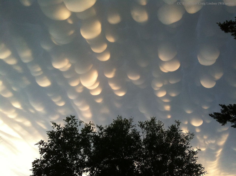
Mammatus clouds, the bubble-shaped protrusions sometimes seen underneath cumulus clouds, are a rare and dramatic type of cloud. The mammatus is typically short-lived, with lobes lasting only 10 minutes or so. Their rarity and short appearances are among the reasons why this cloud type has been little studied. As a result, there are many theories as to how the clouds form their distinctive, bulbous lobes, but, to my knowledge, there is no single widely accepted explanation. Mammatus often appear before or after severe thunderstorms and are associated with strong turbulence, so this may play a factor in their formation. (Photo credit: C. Lindsey; via APOD)
Tag: clouds

“The Chase”
Sometimes it takes timelapse photography to truly appreciate the dynamic behavior of our atmosphere. In “The Chase” Mike Olbinski, whose work we’ve featured previously, has captured some of the most incredible and stunning weather timelapse footage I have ever seen. Despite watching it repeatedly, I continue to be awed to the point that I have no words. Seriously, just watch it. Be amazed by the drama of our sky. (Video credit: M. Olbinski)

Wave Clouds Over the Galapagos
This dramatic example of Kelvin-Helmholtz clouds was taken near the Galapagos Islands last week. The shark-fin-like clouds are the result of two air layers moving past one another. The velocity difference at their interface creates an unstable shear layer that quickly breaks down. The resemblance of the clouds to breaking ocean waves is no coincidence – the wind moving over the ocean’s surface generates waves via the same Kelvin-Helmholtz instability. In the case of the clouds above, the lower layer of air was moist enough to condense, which is why the pattern is visible. Clouds like these don’t tend to last for long because the disturbances that drive the instability grow exponentially quickly, leading to turbulence. (Image credit: C. Miller; via Washington Post; submitted by @jmlinhart)
——————
Help us do some science! I’ve teamed up with researcher Paige Brown Jarreau to create a survey of FYFD readers. By participating, you’ll be helping me improve FYFD and contributing to novel academic research on the readers of science blogs. It should only take 10-15 minutes to complete. You can find the survey here.
Calbuco
Filmmaker Martin Heck captured incredible timelapse footage of the Chilean volcano Calbuco erupting earlier this year. Fluid dynamics on these enormous geophysical scales is always awe-inducing. In the beginning, clouds bob gently and flow around the landscape. Then the volcano erupts, and the towering ash cloud of the eruption roils with turbulence, displaying eddies with length scales from hundreds of meters down to centimeters. And when the hot ash has risen and cooled, it forms a cap that spreads horizontally. Nature is a wonderful demonstrator of fluid dynamics, but what always amazes me is how very alike flows are whether they are confined to a laboratory or take up an entire planet. (Video credit: M. Heck; via It’s Okay To Be Smart)
Cloud Formation
Clouds are so ubiquitous here on Earth that it’s easy to take them for granted. But there’s remarkable complexity in the mechanics of their formation. This great video from Minute Earth steps through the processes of evaporation and condensation that drive basic cloud formation. After evaporation, buoyancy lifts warm, moist air upward. That warm air expands and cools until it reaches an altitude where water droplets can condense onto dust particles in the atmosphere. These droplets form the wispy cloud we see. Turbulence mixes these droplets and helps them collide and grow. Interestingly, although we understand the basic process of cloud formation, relatively little is understood about the details, and the subject is still very much an area of active research. (Video credit: Minute Earth; via io9)
The Earth in Infrared
The motions of Earth’s atmosphere are often invisible to the human eye, but fortunately, we’ve built tools to reveal them. This timelapse video shows the Earth in infrared light, first from a satellite view centered on the Pacific Ocean and second from a satellite centered on Central America. The water vapor in clouds is an excellent insulator, so clouds appear dark in this video. Warmer areas look brighter. The large-scale motion of the atmosphere and the wind bands that cut east and west across the world are apparent in the first half of the video, largely because they are not being interrupted by any land masses. In the second half of the video, the western coast of South America is intermittently visible. This is because the Andes Mountains disrupt air flow, pushing warm, moist air upward and causing it to condense into the dark-colored clouds that recirculate over the Amazon. Look further south along the coast and you’ll see the Atacama Desert flashing white each day as it heats up. (Video credit: J. Tyrwhitt-Drake/NASA; submitted by entropy-perturbation)
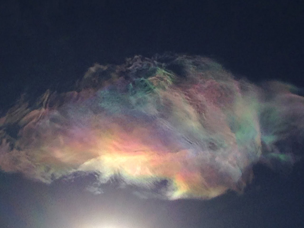
Iridescent Clouds
Look up at the clouds on the right day and you may catch a glimpse of a rainbow-like phenomenon known as cloud iridescence. These colors occur when sunlight is diffracted through small water droplets or ice crystals. For the effect to be apparent, the cloud must be optically thin, meaning that most of the rays of sunlight must pass through only a single droplet or ice crystal. This means the effect is usually visible only near the edges of clouds or as new clouds are forming. You can see more photos of the phenomenon here, and there’s a great video where cloud iridescence makes an appearance during a rocket launch in this previous entry. (Photo credit and submission: C. Havlin)

Kelvin-Helmholtz Clouds
When differing layers of fluid move past one another, friction between them causes shear. This shear quickly transforms a simple flat interface between fluid layers into a wavy unstable boundary that resembles a series of breaking ocean waves. This effect is known as the Kelvin-Helmholtz (KH) instability. In the atmosphere, this instability causes air layers with differing temperatures and moisture content to form wave-like clouds where the two layers meet. Other examples of the effect are widespread. On earth, many ocean waves are generated by wind shearing the water; elsewhere in our solar system, the cloud bands of Jupiter are lined with spinning eddies from the KH instability. (Photo credit: H. Bondo)

Undulatus Asperatus
This surrealistic timelapse doesn’t show an ocean in the sky. These are undulatus asperatus clouds rolling over Lincoln, Nebraska. Also known simply as asperatus, this cloud formation has been proposed as but not yet recognized as a distinctive cloud type. Their speed is much slower than shown in the animation, but the wave-like motion is accurate and is the source of the cloud’s name, which comes from the Latin word aspero, meaning to make rough. Though they appear stormy, asperatus clouds do not usually produce storms. They form under conditions similar to those of mammatus clouds, but wind shear at the cloud level causes the undulations to form. (Maybe some Kelvin-Helmholtz instabilities going on there?) You can check out many more images of asperatus clouds at the Cloud Appreciation Society’s gallery. (Image credit: A. Schueth, source video; submitted by leftcoastjunkies)

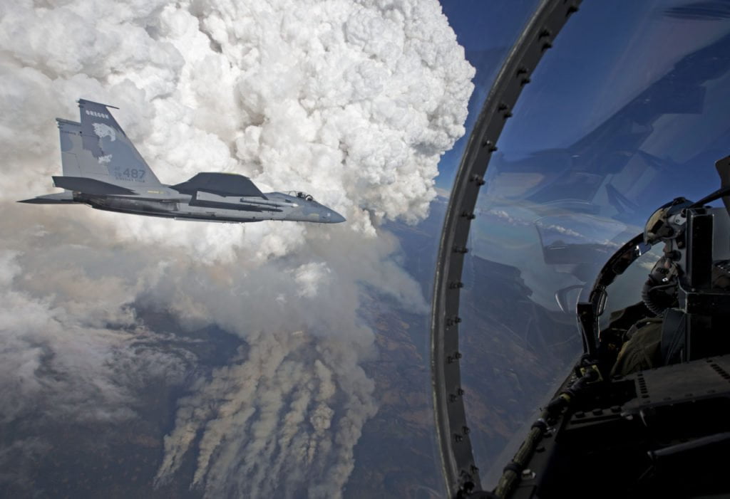
Pyrocumulus Clouds

Pyrocumulus clouds tower tall above a wildfire in these photos taken last week from an Oregon National Guard F-15C. Most cumulus clouds form when the sun-warmed surface heats air, causing it to rise and carry moisture upward where it condenses to form clouds. In pyrocumulus clouds, the driving heat is supplied by a forest fire or volcanic eruption. The hot, rising air carries smoke and soot particles upward, where they become nucleation sites for condensation. Pyrocumulus clouds can be especially turbulent, and the gusting winds they produce can exacerbate wildfires. In some cases, the clouds can even develop into a pyrocumulonimbus thunderstorm with rain and lightning. (Photo credit: J. Haseltine; via NASA Earth Observatory)