Tag: clouds

  • Breaking Waves in the Sky

    Breaking Waves in the Sky

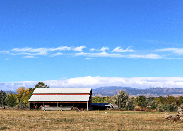
    Under the right atmospheric conditions, clouds can form in a distinctive but short-lived breaking wave pattern known as a Kelvin-Helmholtz cloud. The animation above shows the formation and breakdown of such a cloud over the course of 9 minutes early one morning in Colorado’s Front Range region. Kelvin-Helmholtz instabilities occur when fluid layers with different velocities and/or densities move past one another. Friction between the two layers moving past creates shear and causes the curling rolls seen above.

    In the background, you can also see a foehn wall cloud low to the horizon. This type of cloud forms downwind of the Rocky Mountains after warm, moist Chinook winds are forced up over the mountains, cool, and then condense and sink in the mountains’ wake. (Image credit and submission: J. Straccia, more info)

  • Featured Video Play Icon

    Sky Glow

    This short but spectacular timelapse video shows the Grand Canyon filled with fog. This phenomenon, known as a temperature inversion, occurs when a warm layer of air traps cold, moist air near the ground. As the inversion develops in the video, you can see wisps of clouds popping up in the canyon, seemingly out of nowhere, as moisture evaporated from the surface condenses in the cool air. Once fog fills the canyon, it flows and laps against the canyon’s sides, much like waves on the ocean. In fact, the physics here is quite similar, just at a much slower speed. (Video and image credit: H. Mehmedinovic / SKYGLOWPROJECT; via Gizmodo; submitted by Ian S.)

  • Gravity Waves on Mars

    Gravity Waves on Mars

    It may look like grainy, black and white static from a 20th-century television, but this animation shows what may be the first view of gravity waves seen from the ground on another planet. The animation was stitched together from photos taken by the Mars Curiosity rover’s navigation camera, and it shows a line of clouds approaching the rover’s position.

    Gravity waves are common on Earth, appearing where disturbances in a fluid propagate like ripples on a pond. In the atmosphere, this can take the form of stripe-like wave clouds downstream of mountains; internal waves under the ocean are another variety of gravity wave. If these are, in fact, Martian gravity waves, they are likely the result of wind moving up and over topography, much like their Terran counterparts. (Image credit: NASA/JPL-Caltech/York University; research credit: J. Kloos and J. Moores, pdf; via Science; h/t Cocktail Party Physics)

  • Featured Video Play Icon

    Hawaii’s Lava

    Sometimes the best way to appreciate a flow is standing still. In “Hawaii – The Pace of Formation” filmmakers explore how the Big Island is constantly changing, from fresh lava flows to towering waterfalls. Much of the footage presented is timelapse, which gives viewers a different perspective on familiar subjects; it highlights the similarities between clouds and the ocean, and it reminds us that a lava flow and the syrup flowing down a stack of pancakes have a lot in common. To me, this is one of the most beautiful parts of fluid dynamics: physics of flows on different length-scales and time-scales – even in different fluids – are still very much the same. (Video credit: A. Mendez et al.)

  • Featured Video Play Icon

    Asperitas Clouds

    This short timelapse captures an impressive display of asperitas clouds over Augusta, Georgia. Asperitas clouds, previously known as undulatus asperatus, are a new classification recommended by the Cloud Appreciation Society in 2009. Recently, the World Meteorological Organization indicated they would include the clouds in the their latest Cloud Atlas under the new name. Asperitas clouds form under conditions similar to those of mammatus clouds – in areas with stable, cool, sinking air near the outskirts of thunderstorms. Despite their ominous appearance, the clouds are not themselves an indicator of severe weather – just a spectacular display of our atmospheric dynamics. Happy World Meteorological Day! (Video credit: A. Walters; via Rebekah W/Flow Viz)

  • Creating Clouds

    Creating Clouds

    What you see here is the formation of clouds and rain – but it’s not quite what you’re used to seeing outside. This is an experiment using a mixture of sulfur hexafluoride and helium to create clouds in a laboratory. Everything is contained in a cell between two transparent plates. Liquid sulfur hexafluoride takes up about half of the cell, and when the lower plate is heated, that liquid begins evaporating and rising in the bright regions. When it reaches the cooled top plate, the liquid condenses into droplets inside the dimples on the plate, eventually growing large enough to fall back as rain. The dark wisps you see are areas where cold sulfur hexafluoride is sinking, much like in the water clouds we are used to. Setups like this one allow scientists to study the effects of turbulence on cloud physics and the formation of droplets. (Image credit: E. Bodenschatz et al., source)

    Boston-area folks! I’ll be taking part in the Improbable Research show Saturday evening at 8 pm at the Sheraton Boston. Come hear about the Boston Molasses Flood and other bizarre research!

  • Happy Valentine’s Day

    Happy Valentine’s Day

    This heart-shaped atmospheric apparition is a lenticular cloud captured over the mountains of New Zealand. As you can see in the companion video, the cloud itself remains stationary over the mountain. This is a key feature of lenticular clouds, which form when air flowing over/around an obstacle drops below the dew point. This causes moisture in the air to condense for a time before it descends and warms once more. Thus, even though air is continuously flowing past, what we see is a stationary, lens-shaped cloud. Happy Valentine’s Day from FYFD!  (Image credit: M. Kunze, video; via APOD)

  • Saturnian Clouds

    Saturnian Clouds

    It may look like an oil slick, but the photo above actually shows the clouds of Saturn. The false-color composite image reveals the gas giant in infrared, at wavelengths longer than those visible to the human eye. NASA uses this infrared photography to identify different chemical compositions in Saturn’s atmosphere based on how they reflect sunlight. You can see an example of how they construct these images here. This detail shot appears to show cloud bands of different compositions mixing. You can see hints of shear instabilities forming along the edges  where the light and dark bands meet. (Image credit: NASA; via Gizmodo)

  • Featured Video Play Icon

    Living Fluid Dynamics

    This short film for the 2016 Gallery of Fluid Motion features Montana State University students experiencing fluid dynamics in the classroom and in their daily lives. As in her previous film (which we deconstructed), Shanon Reckinger aims to illustrate some of our everyday interactions with fluids. This time identifying individual phenomena is left as an exercise for the viewer, but there are hints hidden in the classroom scenes. How many can you catch? I’ve labeled some of the ones I noticed in the tags. (Video credit: S. Reckinger et al.)

  • Roll Cloud Over Chicago

    Roll Cloud Over Chicago

    A cold front passing through Chicago last week triggered a roll cloud, shown in the timelapse above. These clouds look like spinning horizontal tubes and form in areas where cool, sinking air displaces warmer, moist air to higher altitudes. The moist air is forced up along the cloud’s leading edge, causing it to cool and condense into cloud. Air on the trailing edge sinks downward again, warming and dissipating the cloud. The clouds are a visible form of soliton, or solitary wave, traveling through the atmosphere. They go by several other names, too, including Morning Glory clouds and arcus clouds. (Image credit: A. King; via Colossal)