
When differing layers of fluid move past one another, friction between them causes shear. This shear quickly transforms a simple flat interface between fluid layers into a wavy unstable boundary that resembles a series of breaking ocean waves. This effect is known as the Kelvin-Helmholtz (KH) instability. In the atmosphere, this instability causes air layers with differing temperatures and moisture content to form wave-like clouds where the two layers meet. Other examples of the effect are widespread. On earth, many ocean waves are generated by wind shearing the water; elsewhere in our solar system, the cloud bands of Jupiter are lined with spinning eddies from the KH instability. (Photo credit: H. Bondo)
Search results for: “kelvin-helmholtz instability”

Kelvin-Helmholtz in the Lab
The Kelvin-Helmholtz instability looks like a series of overturning ocean waves and occurs between layers of fluids undergoing shear. This video has a great lab demo of the phenomenon, including the set-up prior to execution. When the tank is tilted, the denser dyed salt water flows left while the fresh water flows to the right. These opposing flow directions shear the interface between the two fluids, which, once a certain velocity is surpassed, generates an instability in the interface. Initially, this disturbance is much too small to be seen, but it grows at an exponential rate. This is why nothing appears to happen for many seconds after the tilt before the interface suddenly deforms, overturns, and mixes. In actuality, the unstable perturbation is present almost immediately after the tilt, but it takes time for the tiny disturbance to grow. The Kelvin-Helmholtz instability is often seen in clouds, both on Earth and on other planets, and it is also responsible for the shape of ocean waves. (Video credit: M. Hallworth and G. Worster)
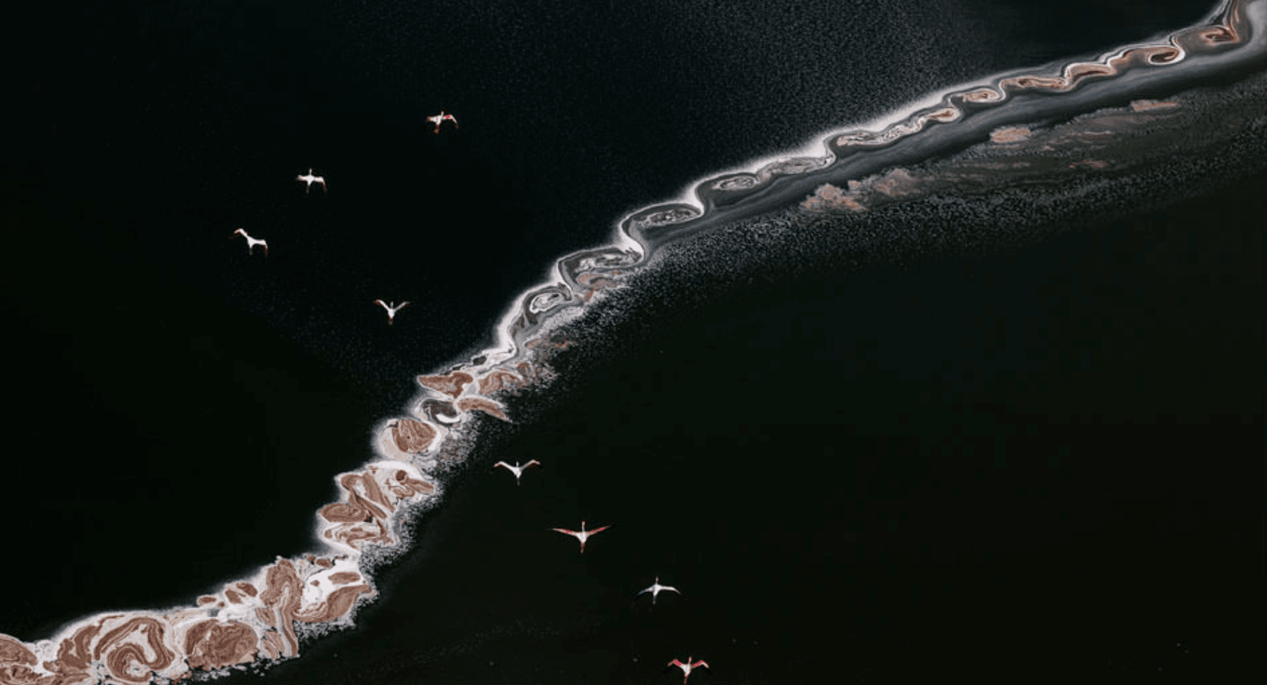
Salty Swirls
Flamingos soar over swirls of salt and algae in a lake in Kenya’s Rift Valley. Shaped by winds, currents, physics, and chemistry these eddies reflect the motion of the water, evaporation patterns, and more. Without more information, it’s hard to say exactly what shapes the pattern, but it does appear reminiscent of a Kelvin-Helmholtz instability in places. (Image credit: B. Hayden/IAPOTY; via Colossal)
Fediverse Reactions
-

Rotating Waves of Grains
Rotating drums are a popular way to explore granular dynamics. Here, researchers fill a cylinder (seen below) with heavy grains and a low-viscosity fluid, then rotate the mixture about a horizontal axis. This sets up a contest between centrifugal forces and gravitational forces on the grains. At the right rotation rates, the grains form annular rings around the outside of the cylinder, where they rotate at a different speed than the fluid. This difference in speed between the two layers can trigger a Kelvin-Helmholtz instability and cause waves along the interface between the grains and the fluid, as seen in the examples above. (Image and research credit: V. Dyakova and D. Polezhaev; top image adapted by N. Sharp)


Where Wind Meets Water
That the wind causes ocean waves is obvious to anyone who has spent time near the water, but the details of that process remain fuzzy. Many of the explanations — like the Kelvin-Helmholtz instability — only explain part of the process, usually the beginning when the waves are very small. As the waves get larger, they affect the wind in turn, complicating matters.
As messy as the theory gets, our ability to measure the wind and water in situ is limited, too. Just look at this wild research platform oceanographers designed to study wind and waves. It’s part of a 355-ft vessel that’s towed out to sea horizontally and then flipped so that 300 feet of it remain underwater to stabilize the remainder for measurements. Even with equipment like this, measuring the turbulent air and water near the ocean-sky interface is incredibly difficult.
This review article gives a nice overview of different historical efforts to explain how wind makes waves and provides a snapshot of the latest research in the area. (Image credit: R. Bilcliff; see also N. Pizzo et al.)

Superfluid Instabilities


Superfluids — like Bose-Einstein condensates — are bizarre compared to fluids from our everyday experience because they have no viscosity. Without viscosity, it’s no surprise that they behave in unusual ways. Here, researchers simulated superfluids moving past one another. In each of these images, the blue fluid is moving to the left, and the red fluid is moving to the right. In a typical fluid, such motion causes ocean-wave-like curls due to the Kelvin-Helmholtz instability.
Instead, with a low relative velocity and high repulsion between atoms of the two layers, the superfluids form a tilted, finger-like interface (Image 1) that the authors refer to as a flutter-finger pattern. (Repulsion essentially sets the miscibility between the superfluids. With a high repulsion, the superfluids resist mixing.)
With a higher relative velocity (Image 2), the wavelength of the ripples becomes comparable to the thickness of the interface, and the superfluids take on a very different, zipper-like pattern. Note how the tips detach and reconnect to the neighboring finger!
With lower repulsion, the interface between the two liquids is thicker and breaks down quickly (Image 3). The authors call this a sealskin pattern. (Image credits: water – M. Blažević, simulations – H. Kokubo et al.; research credit: H. Kokubo et al.; via APS Physics)

Brace For Impact
What happens in the moment before an object hits the water? That’s the question at the heart of a new study exploring how water deforms before an object’s impact. The researchers dropped circular disks onto a pool of water and, using a new reflection-based technique, measured micron-sized deflections in the water’s surface before impact, as seen below.

Movie of the water surface’s deflection as the circular disk approaches. Look for distortions in the grid pattern. The deflections are caused by the air getting squeezed out of the space between the oncoming object and the water surface. The team found that the deformation isn’t uniform. The air squeezing out along the edges moves fast enough to trigger a Kelvin-Helmholtz instability and actually pull up the water surface. So when the disk hits, it impacts along its edges first and traps an air bubble underneath. (Image credits: divers – E. Carter, experiment – U. Jain et al.; research credit and submission: U. Jain et al.)

Sunset Swirls
This gorgeous photograph of Kelvin-Helmholtz clouds was taken in late December in Slovenia by Gregor Riačevič. The wave-like shape of the Kelvin-Helmholtz instability comes from shear between two fluid layers moving at different relative speeds. Here on Earth, clouds like these are often short-lived, but we see similar structures in the atmospheres of gas giants like Jupiter and Saturn. (Image credit: G. Riačevič; submitted by Matevz D.)
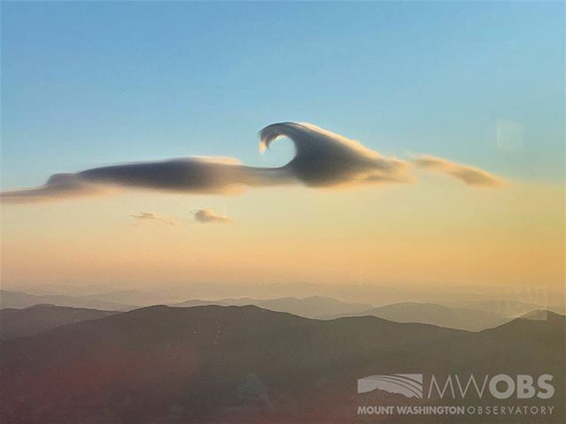
A Lenticular Cloud With a Curl
Lens-shaped lenticular clouds are not terribly rare in mountainous areas, but observers at Mount Washington caught a very unusual cloud near sunrise in late February. This lenticular cloud had an added curl on top thanks to the Kelvin-Helmholtz instability!
Lenticular clouds form when air is forced to flow up over a mountain in such a way that its temperature and pressure drop and water vapor in the air condenses. The resulting water droplets form a cloud that appears stationary over the mountain, even though the air continues to flow.
To get that added wave-like curl, there needs to be another, faster-moving layer of air just above the cloud. As that air flows past, it shears the cloud layer, causing the interface to curl. Neither of these cloud types is long-lived — Kelvin-Helmholtz formations often last only a few minutes — so catching such a great dual example is lucky, indeed! (Image credit: Mount Washington Observatory; via Smithsonian Magazine; submitted by Kam-Yung Soh)

Wave Clouds in the Front Range
Last Sunday night metro Denver was treated to a rare sight: clouds resembling breaking waves formed near sunset. These are Kelvin-Helmholtz clouds, and the comparison to ocean waves is apt, since the same physics is behind both. Winds were unusually calm near the ground Sunday night, but strong winds blew at the altitude just above the lower cloud layer. That velocity difference created strong shear where the two air layers met. With the cloud layer in place to differentiate the slower-moving air from the faster, we can what’s normally invisible: how the two air layers mix.
The Denver Post has several more views of the wave clouds from around the area, and you can learn lots more about the Kelvin-Helmholtz instability here. (Image credit: R. Fields; via the Denver Post)