As the climate warms, many urban centers are facing stronger and more frequent storms. Some, like New York City, are using numerical simulations to better understand the interactions of their complicated urban geometries with hurricane force winds.
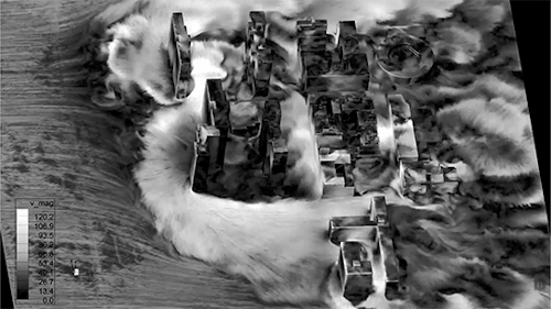
Above you see a simulation showing predicted wind speeds in a Lower Eastside neighborhood. The incoming wind speed (from the left) is roughly 60 m/s (~134 mph), but the speeds around and between buildings are as much as 2 times higher than that. That means that, even if a storm is Category 3 or 4, there will be areas of a neighborhood that receive sustained winds well beyond the range of a Category 5 hurricane. Urban planners need this sort of data both for devising building requirements and for understanding what storm conditions warrant mandatory evacuations for residents. (Video and image credit: X. Jiang et al.)
Leave a Reply