Mike Olbinski’s “Vorticity 3” is a stunning view of storm chasing in the American West. I’ve learned after years in Colorado to always look up because dramatic skies are common here, as is seeing rain falling miles away. Olbinski’s film captures all of that grandeur and more, giving all of us a glimpse inside the incredible storms that mark the summer months in this region. You’ll see spinning supercell thunderstorms, bulbous mammatus clouds, towering cumulus clouds, and more. (Video and image credit: M. Olbinski)
Tag: weather
Mammatus Clouds
Mammatus clouds are a relatively rare and dramatic variety. One advantage of living in Colorado is that I see them somewhat often, especially during our stormy springs and summers. This video by Mike Olbinski features a dramatic skyscape of mammatus clouds (here in Colorado, natch) at sunset.
Although they’re often associated with stormy weather, there’s no widely accepted theory as to how mammatus clouds form. Their lobe-like protrusions form from cold, sinking air, but this is about as far as theories agree. It’s even unclear what their relation to extreme weather may be since these short-lived cloud formations can appear around, before, or even after such weather. (Image and video credit: M. Olbinski)
A Year From Geostationary Orbit
Our planet is a complex fluid dynamical system, and one of the best ways to watch nature at work is through timelapse. This short film takes us through an entire year, from December 2015 to December 2016, as viewed from a geostationary weather satellite centered over Oceania.
The imagery is rather hypnotic, with clouds swirling day and night across the full field of view. Watch closely, though, and you’ll see a lot of neat phenomena from typhoons forming in the Pacific to wave clouds streaming from the islands of Japan. You can also see clouds blossoming (especially during the day) over the humid rainforests of Oceania.
There are neat non-fluids phenomena, too, like a total solar eclipse and the permanent sunlight of Arctic and Antarctic summers. What do you notice? (Image and video credit: F. Dierich)
Swirling Vortex
So much of fluid dynamics comes down to finding the right way to observe a flow. This image of a swirling tropical system was captured by an astronaut aboard the International Space Station in April 2019. The low sun angle at the time makes the shadows stretch long across the cloud tops, giving them greater definition as well as a tint of sunset color. As drastic as the system looks from this angle, it was a short-lived vortex that never made landfall, so it was never officially named. (Image credit: Expedition 59 Crew; via NASA Earth Observatory)
“Transient 2”
Where cold and warm air meet, our atmosphere churns with energy. From the turbulence of supercell thunderclouds to the immense electrical discharge of lightning, there’s much that’s breathtaking about stormy skies. Photographer Dustin Farrell explores them, with a special emphasis on lightning, in his short film, “Transient 2″.
As seen in high-speed video, lightning strikes begin with tree-like leaders that split and spread, searching out the path of least resistance. Once that line from cloud to ground is discovered, electrons flow along a plasma channel that arcs from sky to earth. The estimated temperatures in the core of this plasma reach 50,000 Kelvin, far hotter than the Sun’s surface. It’s this heating that generates the blue-white glow of a lightning bolt. The heating also expands the air nearby explosively, producing the shock wave we hear as a crash of thunder. (Images and video credit: D. Farrell et al.; via Colossal)
Waves on a Supercell
This Colorado supercell thunderstorm features an unusual twist. Notice the sawtooth-like protrusions along the outer cloud wall. These are Kelvin-Helmholtz waves, like these fair-weather clouds we’ve seen before, but instead of occurring vertically, they project horizontally! That implies that the invisible layer of air just outside the cloud wall is moving faster than the wall itself. That creates shear along the outer edge of the cloud wall and causes these waves to form. This is the first time I’ve ever seen this sort of thing. What an awesome photo! (Image credit: M. Charnick; submitted by jpshoer)
Striped Clouds
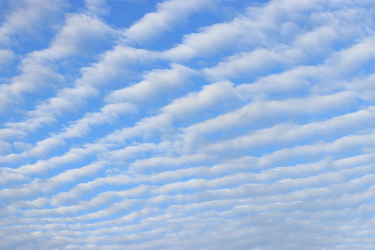
Living near the Rocky Mountains, it’s not unusual to look up and find the sky striped with lines of clouds. Such wave clouds are often formed on the lee side of mountains and other topography. But even in the flattest plains, you can find clouds like these at times. That’s because the internal waves necessary to create the clouds can be generated by weather fronts, too.
Imagine a bit of atmosphere sitting between a low-pressure zone and a high-pressure zone. This will be an area of convergence, where winds flow inward and squeeze the fluid parcel in one direction before turning 90 degrees and stretching it in the perpendicular direction. The result is a sharpening of any temperature gradient along the interface. This is the weather front that moves in and causes massive and sudden shifts in temperature.
On one side of the front, warm air rises. Then, as it loses heat and cools, it sinks down the cold side of the front. The sharper the temperature differences become, the stronger this circulation gets. If the air is vertically displaced quickly enough, it will spontaneously generate waves in the atmosphere. With the right moisture conditions, those waves create visible clouds at their crests, as seen here. For more on the process, check out this article over at Physics Today. (Image credit: W. Velasquez; via Physics Today)
Tornado from a Drone
One of the challenges in studying tornadoes is being in the right place at the right time. In that regard, storm chaser Brandon Clement hit the jackpot earlier this week when he captured this footage of a tornado near Sulphur, Oklahoma from his drone. He was able to follow the twister for several minutes until it apparently dissipated.
Scientists are still uncertain exactly how tornadoes form, but they’ve learned to recognize the key ingredients. A strong variation of wind speed with altitude can create a horizontally-oriented vortex, which a localized updraft of warm, moist air can lift and rotate to vertical, birthing a tornado. These storms most commonly occur in the central U.S. and Canada during springtime, and researchers are actively pursing new ways to predict and track tornadoes, including microphone arrays capable of locating them before they fully form. (Image and video credit: B. Clement; via Earther)
The Polar Vortex
Every year or two, the Northern Hemisphere gets treated to a bout of intensely cold temperatures thanks to the polar vortex. What you may not realize, though, is that it’s not the polar vortex that causes this cold weather – it’s the vortex breaking down. As Simon Clark explains in this video, the polar vortices (one at each pole) are intense and powerful regions of circulation in the stratosphere, or mid-atmosphere. They’re largely responsible for keeping cold air trapped in the Arctic and Antarctic. But occasionally, this region of the atmosphere will suddenly get warmer – to the tune of increasing by 80 degrees Celsius in less than a week! When this happens, a polar vortex will deform and potentially even split into smaller vortices, as seen below. When this happens, the vortex loses its hold on the cold air near the surface, allowing Arctic air to sneak as far south as Texas. After a couple of weeks of affecting our weather, the polar vortex will typically reform and we’ll return to normal. In the meantime, stay warm! (Video and image credit: S. Clark; submitted by Nikhilesh T.)
The Great Smog of London
Our atmosphere is active and ever-changing – except when it isn’t. Some areas, including many cities, are prone to what’s known as a temperature inversion, where a layer of cooler air gets trapped underneath a warmer one. Because this means that a dense layer is caught under a less dense one, the situation is stable and – absent other changes in circumstances – will stick around. There are several ways this can happen, including overnight when areas near the ground cool faster than the atmosphere higher up.
When temperature inversions persist, they can trap pollutants and create health hazards. One of the worst of these recorded occurred in December 1952 in London. An anticyclone created a temperature inversion over the city that trapped smoke from coal burned to warm homes and reduced visibility – sometimes even indoors – to only a meter or two. Thousands of people died from the respiratory effects of the five-day smog, and it prompted major efforts to improve emissions and air quality. Temperature inversions cannot be avoided, but the Great Smog of London taught us the necessity of reducing their danger. (Image credit: Getty Images)