Tag: condensation

  • Bendable Ice

    Bendable Ice

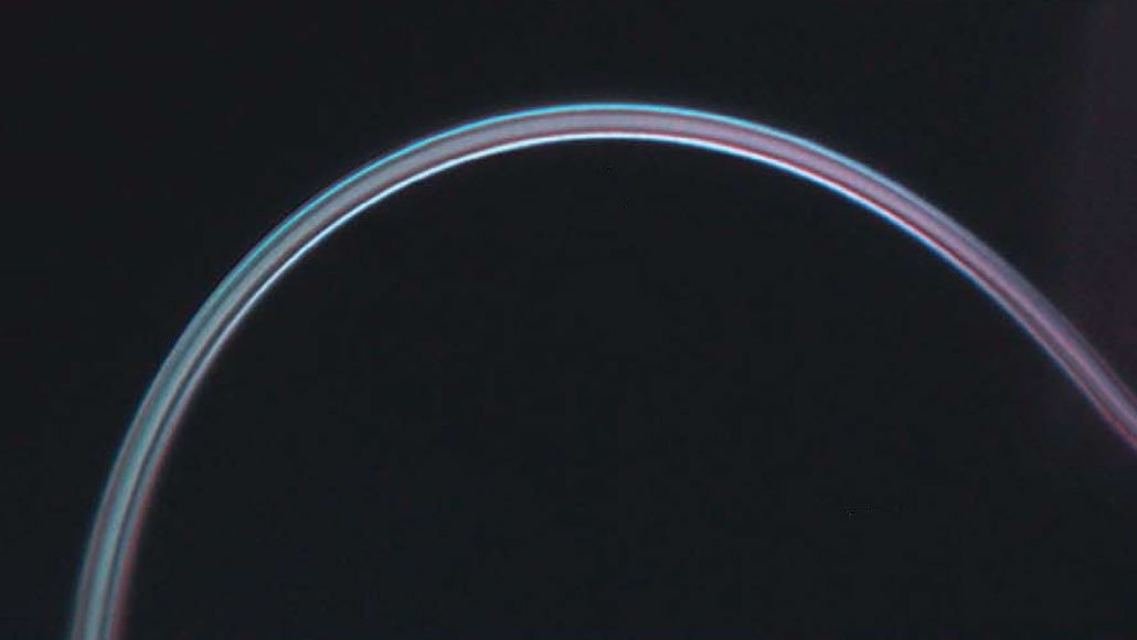
    Ice — as we typically encounter it — is extremely brittle and easily broken. That’s due to defects in the ice, places where atoms have settled into a spot that does not match the perfect crystalline alignment. Because tiny defect-free threads of ice made by researchers turn out to be wildly flexible!

    To make these perfect ice strands, each of which is a tiny fraction of the thickness of a human hair, researchers applied an electric voltage to a needle in a water-vapor-filled chamber. The technique condensed ice microfibers with perfect crystal structures in a matter of seconds. When bent, the microfibers actually shift from one crystalline arrangement to another in order to carry stress, and once the force is removed, the thread reverts back to its initial straight form. (Image and research credit: P. Xu et al.; via Science News; submitted by Kam-Yung Soh)

  • Cloud-Making Waves

    Cloud-Making Waves

    As sea ice disappears in the Arctic Ocean, it leaves behind higher waves on the open water. These large waves help inject sea salt and organic matter into the atmosphere, where they can serve as nucleation sites for ice crystals. A recent field expedition in the Chukchi Sea observed high concentrations of organic particulates in the air and more ice-producing clouds during periods of high wave action. So, oddly enough, the loss of sea ice may lead to more cloud cover and precipitation in the Arctic (though the effect is likely not strong enough to entirely mitigate the effects of ice loss). It’s another example of the intricate and complex connections between ice, ocean, and atmosphere in the Arctic climate. (Image credit: A. Antas-Bergkvist; research credit: J. Inoue et al.; via Gizmodo)

  • Bullseye

    Bullseye

    The Cumbre Vieja volcano in the Canary Islands began erupting in mid-September 2021. This satellite image, captured October 1st, shows a peculiar bullseye-like cloud over the volcano. Hot water vapor and exhaust gases rose rapidly from the erupting volcano until colliding with a drier, warmer air layer at an altitude of 5.3 kilometers. The warm upper layer, known as a temperature inversion, prevented the volcanic gases from rising any further, so they instead spread horizontally. The outflow from the volcano varies and is non-uniform, and its fluctuations generated gravity waves that are visible here as the expanding rings of clouds. (Image credit: L. Dauphin; via NASA Earth Observatory)

  • Noctilucent Clouds

    Noctilucent Clouds

    Noctilucent clouds are the “highest, driest, coldest, and rarest clouds on Earth.” Formed in the mesosphere at altitudes over 80 kilometers, these clouds typically form at polar latitudes where they can catch sunlight hours after sunset, hence their night-shining name. The clouds take shape when water vapor in cold mesospheric air layers freezes onto dust left behind by meteors.

    Fun fact: because of their high altitude and particle size and density, noctilucent clouds were considered a hazard for space shuttle reentry, and planners explicitly avoided trajectories that would take the spacecraft near potential clouds. (Image credit: top – N. Fewings, other – J. Stevens/NASA Earth Observatory)

    Satellite image of noctilucent clouds above the North Pole.
  • Featured Video Play Icon

    Visualizing Radiation

    Radiation is invisible, but it’s not too difficult to build an apparatus that lets you see it. This video shows the ghostly aftermath of passing radiation in a cloud chamber, one of the first set-ups used to study radiation. The chamber contains a radioactive source and chilled isopropyl alcohol. The alcohol forms a supersaturated vapor — essentially a cloud in waiting — inside the chamber.

    When a radioactive particle gets emitted from the source, it streaks through the chamber, colliding with atoms and ionizing them. Those ions then serve as nucleation sites where alcohol condenses into droplets. It’s these condensation trails that we see bloom and decay in the particle’s wake. (Image and video credit: L. Gledhill)

  • Fallstreak Holes

    Fallstreak Holes

    Occasionally clouds appear to have a hole in them; these are known as fallstreak holes or hole-punch clouds. To form, the water droplets in the cloud must be supercooled; in other words, they must be colder than their freezing point but still in liquid form. When disturbed — say, by the temperature drop caused by flowing over an airplane wing — the supercooled water droplets will suddenly freeze. This typically kicks off a chain reaction in which many droplets freeze and the heavy ice crystals fall out of the sky, leaving behind a void in the cloud. Because airplanes are particularly good at creating these fallstreak holes, they’re often seen near busy airports. (Image credit: J. Stevens/NASA; via NASA Earth Observatory)

  • Featured Video Play Icon

    “Mist and Water”

    Years ago, I drove through the Blue Ridge Mountains on a wet and misty New Year’s Day. The fog that clung to the dark trees made the whole world quiet and surreal. And although Mike Olbinski’s “Mist and Water” takes place on the opposite side of the country in Oregon, that’s what the video reminds me of. So take a few minutes to enjoy the calm of mist and water flowing in this beautiful short film. (Image and video credit: M. Olbinski)

  • As the Fog Rolls In

    As the Fog Rolls In

    Although we talk about fog rolling in, it’s rare for us to have a perspective where we can truly appreciate that flow. But this photograph from Tanmay Sapkal provides just that for the low summer fogs sweeping over Marin, CA. When hot summer temperatures make inland air rise, cold, moist air from the ocean sweeps in to replace it. Once the moisture condenses, it forms thick, low clouds of fog that surge past the Golden Gate Bridge and into San Francisco Bay. (Image credit: T. Sapkal; via NatGeo)

  • Bright Volcanic Clouds

    Bright Volcanic Clouds

    Every day human activity pumps aerosol particles into the atmosphere, potentially altering our weather patterns. But tracking the effects of those emissions is difficult with so many variables changing at once. It’s easier to see how such particles affect weather patterns somewhere like the Sandwich Islands, where we can observe the effects of a single, known source like a volcano.

    That’s what we see in this false-color satellite image. Mount Michael has a permanent lava lake in its central crater, and so often releases sulfur dioxide and other gases. As those gases rise and mix with the passing atmosphere, they can create bright, persistent cloud trails like the one seen here. The brightening comes from the additional small cloud droplets that form around the extra particles emitted from the volcano.

    As a bonus, this image includes some extra fluid dynamical goodness. Check out the wave clouds and von Karman vortices in the wake of the neighboring islands! (Image credit: J. Stevens; via NASA Earth Observatory)

  • Featured Video Play Icon

    “Vorticity 3”

    Mike Olbinski’s “Vorticity 3” is a stunning view of storm chasing in the American West. I’ve learned after years in Colorado to always look up because dramatic skies are common here, as is seeing rain falling miles away. Olbinski’s film captures all of that grandeur and more, giving all of us a glimpse inside the incredible storms that mark the summer months in this region. You’ll see spinning supercell thunderstorms, bulbous mammatus clouds, towering cumulus clouds, and more. (Video and image credit: M. Olbinski)