
During winter, the polar skies can ignite with mother-of-pearl-like iridescence. Polar stratospheric clouds – also known as nacreous clouds – are a rare, beautiful, and destructive type of cloud found only in high latitudes at altitudes of 15 – 25 km. They are formed from tiny crystals of ice and nitric acid, and they shine brightest a few hours before sunrise or after sunset, when sunlight shines on them but not the surface. Their destructive side is connected with ozone depletion; they serve as reaction sites for chlorofluorocarbons in the atmosphere to react and produce ozone-destroying molecules. The clouds may have cultural significance as well; at least one study suggests they were part of Munch’s inspiration for “The Scream”. (Image credit: A. Light; via Gizmodo)
Tag: clouds
Pyrocumulus on the Horizon
The Cranston wildfire in California is intense enough that it’s creating its own weather. This timelapse video shows the formation and growth of a pyrocumulus cloud, also associated with volcanoes, over the wildfire. In both instances, the extreme heat causes a massive column of hot, turbulent air to rise. Because ash and smoke are carried upward as well, there are many places for any moisture in the atmosphere to nucleate, forming the cloud we see. In timelapse, the roiling nature of the air’s motion is especially apparent. This turbulence can be dangerous, as it may contribute to high winds and even lightning, both of which can spread the fire further. (Video credit: J. Morris; via James H.)

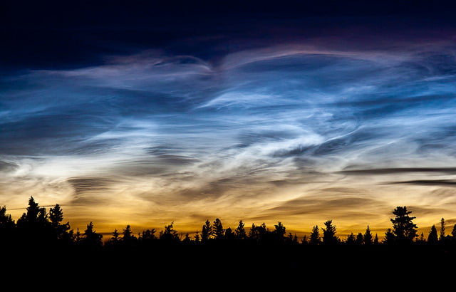
Night Shine
Noctilucent – literally night-shining – clouds are a phenomenon unique to high latitudes during the summer months. Too dim and sparse to see in daylight, these clouds shine at night because their altitude of around 80 km allows them to catch sunlight long after dusk has fallen at the surface. They form when temperatures in the summer mesosphere drop to nearly -150 degrees Celsius, driven by perturbations that can originate in lower layers of the atmosphere on the opposite side of the Earth. Complex interactions and feedback between atmospheric waves, buoyancy, and Coriolis effect circulate those disturbances in such a way that the summer mesosphere can reach temperatures colder than any other place on Earth. Those frigid temperatures allow clouds to form even in this dry region near the edge of space. (Image credit: S. Stephens; see also: B. Karlsson and T. Shepard)

Jupiter’s Swirls


Sometimes it amazes me that the Juno spacecraft was originally designed without any cameras onboard. The JunoCam instrument has produced stunning imagery of Jupiter thus far and shows no signs of stopping soon. The latest wonder is this false-color, high-contrast animation showing the motion of Jupiter’s clouds swirling and flowing past one another.
Now, this is not Jupiter as you would see it by eye. This animation is derived from two images taken 8 minutes and 41 seconds apart. In that time, Juno covered a lot of distance, so the two images had to be mathematically re-projected so that they appeared to be taken from the same location. Then, by comparing relative positions of recognizable features in the two photos and applying some understanding of fluid mechanics, observers could calculate the probable flow between those two states. Although this is a coarse example, it’s the same kind of technique often used in fluid dynamical experiments when measuring how flows change between two images. (Image credit: NASA/JPL/SwRI/MSSS/G. Eichstädt, source; via EuroPlanet; submitted by Kam-Yung Soh)

Wave Clouds
Stripe-like wave clouds can often form downstream of mountains. This satellite image shows such clouds in the South Pacific where rocky mountains jut 600 meters (2,000 ft) above the sea. This disrupts air flowing east by forcing it to move up and over the island topography. The air does not simply settle back down on the other side, though. It must come back into equilibrium with its surroundings in terms of density and temperature. While doing so it will travel up and down along a wavy path. As it reaches the crest of the wave, humid air cooling condenses and forms a cloud. At troughs, the air warms and the condensation disappears. This creates the stripey cloud pattern in the mountain’s wake, which fades out as the atmospheric gravity waves die out. (Image credit: NASA/J. Schmaltz; via NASA Earth Observatory)

Castle-like Clouds
An astronaut captured this towering cloud over Andros Island from orbit aboard the ISS. This is a cumulus castellanus cloud, named for the castle-like crenelations at its top. Castellanus clouds form in areas with strong vertical updrafts, often due to cloud-level atmospheric instabilities rather than heating at the Earth’s surface. These clouds frequently proceed rain or even thunderstorms. What distinguishes castellanus from other types of cumulonimbus clouds is their shape: castellanus clouds have protrusions that are taller than they are wide – like the castles for which they are named. (Image credit: NASA / Expedition 48; via NASA Earth Observatory)

“Breathe”


In black and white, the towering power of a thunderstorm looks almost apocalyptic. Photographer Mike Olbinski’s latest storm timelapse, “Breathe,” features roiling turbulence, distant downpours, and eerie mammatus clouds. Supercell thunderstorms churn and rotate over empty horizons. Billowing cumulus clouds condense from bright skies. Flashes of lightning reveal the outlines of massive thunderheads. It’s a beautiful glimpse of atmospheric fluid dynamics in action, with every texture magnified and enhanced by the stark black and white palette. (Video and image credit: M. Olbinski; via Gizmodo)

Juno’s Citizen Science


The Juno mission’s JunoCam has been producing stunning photos each time the spacecraft swoops past Jupiter. The instrument has a planning team, but its primary use is for citizen scientists, who have been suggesting images to take each orbit and have been processing those images. Most of the photos we see are like the one on the left above – photos that have been heavily color-enhanced to highlight details. The image on the right shows what Jupiter would look like to the human eye. Look closely, and you’ll catch many of the same colors and shapes in both photos.
At a recent conference, a member of JunoCam’s team presented scientific results that have come from the instrument, including analysis of Jupiter’s polar storm systems (8 vortices for the north pole and 5 for the south), tantalizing hints at Jovian equivalents to earthly cloud types, and more. She also announced a new Analysis page where members of the public can both see the science in progress and participate first-hand! (Image credit: NASA / SwRI / MSSS / G. Eichstädt / S. Doran; NASA / JPL-Caltech / SwRI / MSSS / B. Jónsson; via E. Lakdawalla; submitted by jshoer)
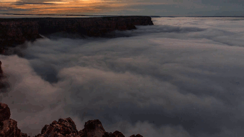
The Foggy Grand Canyon
On occasion in the late fall and early winter, the Grand Canyon can fill with clouds of fog. This occurs when a layer of warm air traps cold, moist air inside the canyon, creating what’s known as a temperature inversion. The trapped air’s moisture condenses into fog, creating the appearance of a cloud sea lapping at the canyon walls. Such inversions often proceed a big snowstorm, as shown in this video. (Video and image credit: H. Mehmedinovic / SKYGLOWPROJECT; via Gizmodo)


Lincolnshire KH Clouds


These beautiful Kelvin-Helmholtz clouds were spotted over Lincolnshire on December 19th. They form between two layers of air, one of which is moving faster than the other. Although that situation is not very unusual, the conditions have to be just right for visible clouds to form at that interface between layers, and the clouds themselves are typically short-lived. This set is particularly lovely with its smooth curves and breaking wave form. If you, like me, love these clouds but never manage to see them yourself, you can always try wearing some instead! (Image credit: A. Towriss; via BBC News; submitted by Vince D.)


