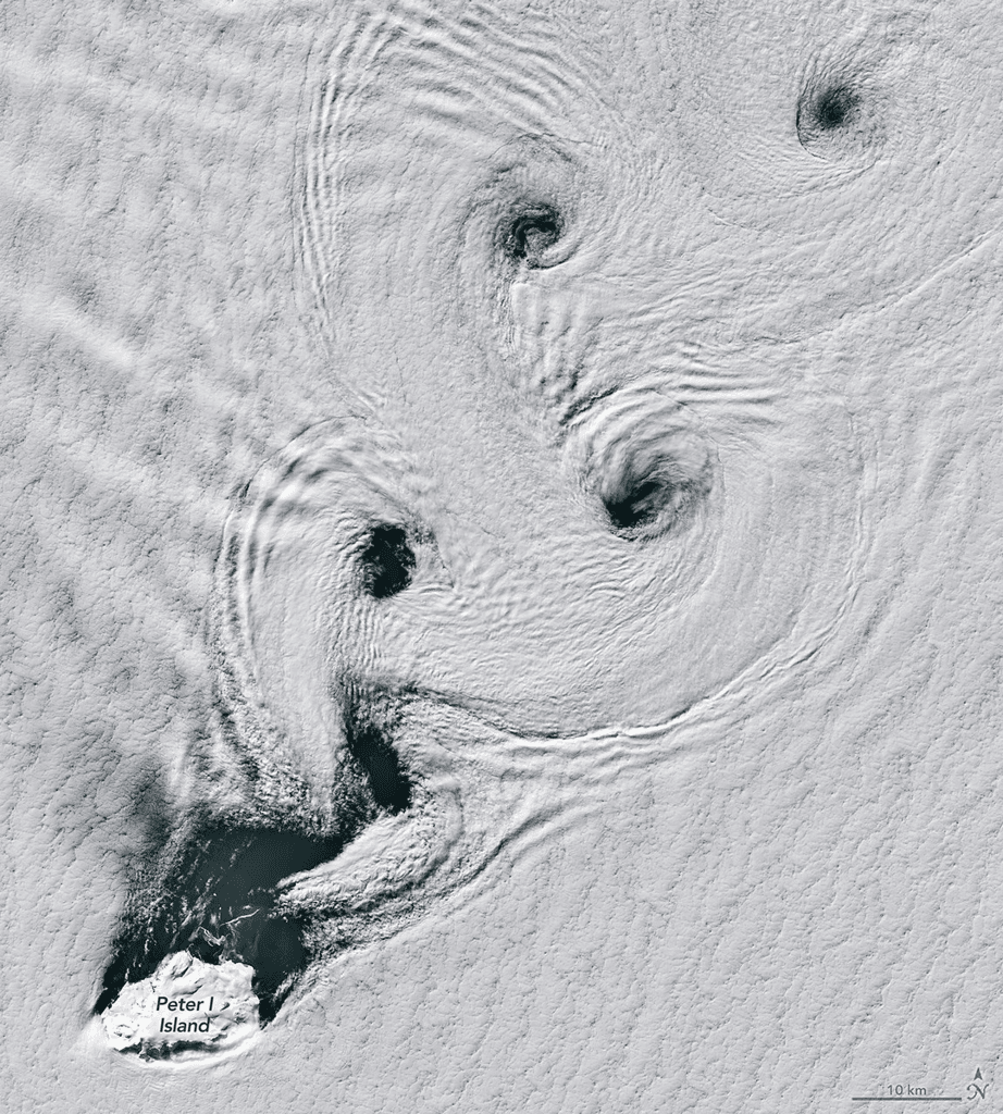
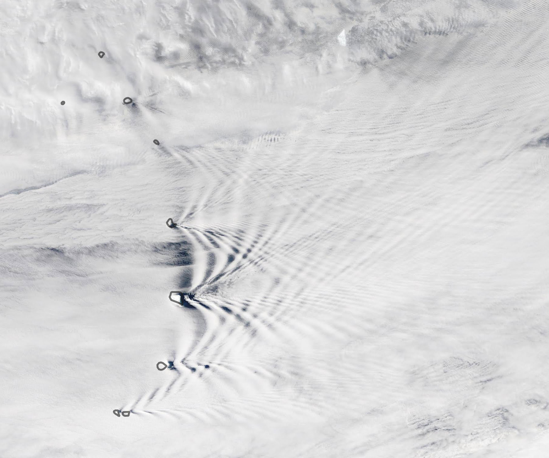
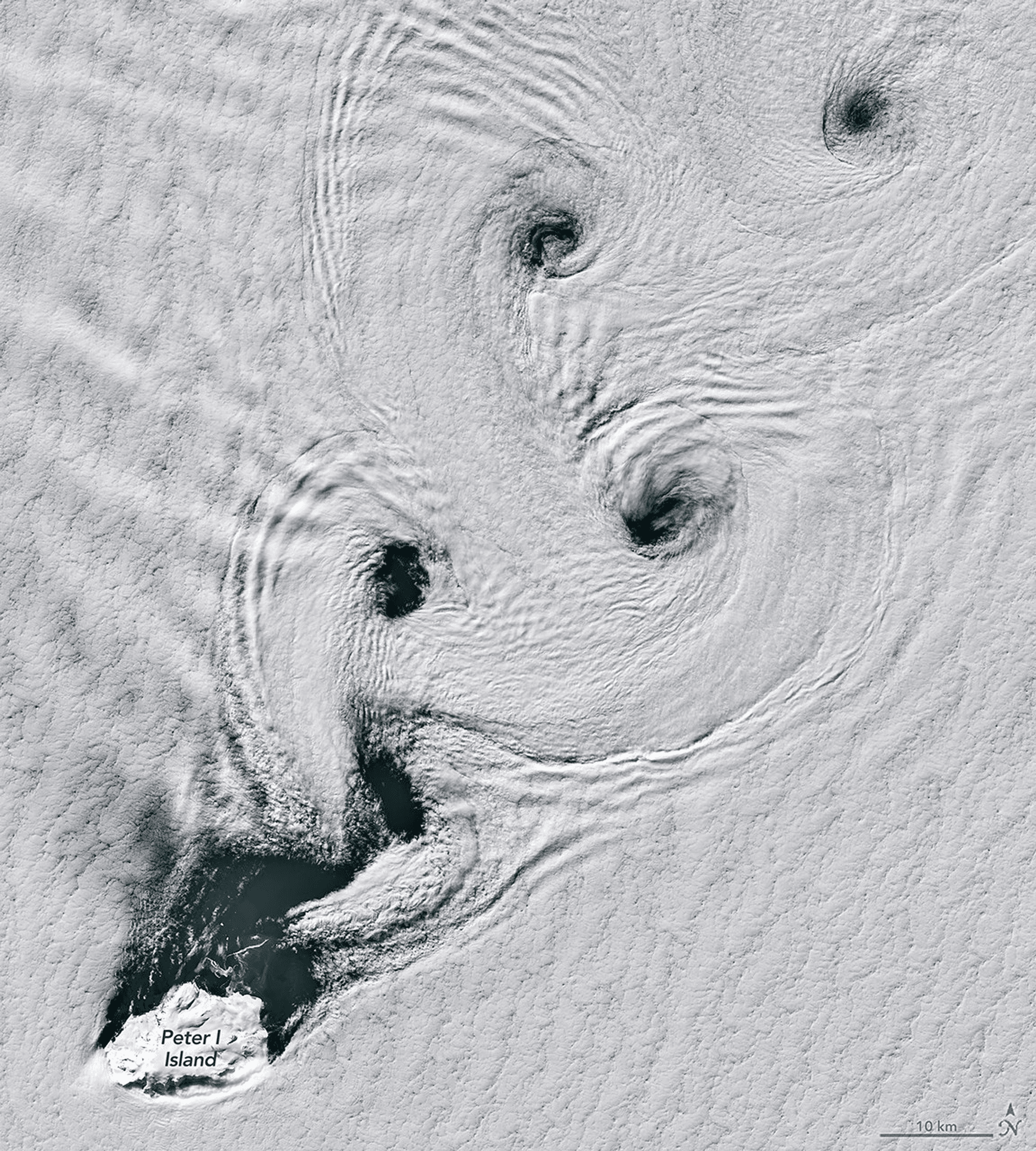
Tag: lee waves

  • Wave Clouds in the Atacama

    Wave Clouds in the Atacama

    Striped clouds appear to converge over a mountaintop in this photo, but that’s an illusion. In reality, these clouds are parallel and periodic; it’s only the camera’s wide-angle lens that makes them appear to converge.

    Wave clouds like these form when air gets pushed up and over topography, triggering an up-and-down oscillation (known as an internal wave) in the atmosphere. At the peak of the wave, cool moist air condenses water vapor into droplets that form clouds. As the air bobs back down and warms, the clouds evaporate, leaving behind a series of stripes. You can learn more about the physics behind these clouds here and here. (Image credit: Y. Beletsky; via APOD)

    Fediverse Reactions
  • Crisscrossing Wave Clouds

    Crisscrossing Wave Clouds

    Crisscrossing lines of wave clouds mark the wake of the Sandwich Islands in this satellite image. The tallest islands in the chain thrust rocky peaks more than 1000 meters above sea level, disrupting winds flowing across the ocean. Incoming air is forced up and over the mountain, which puts it at odds with the surrounding air at that height.

    Due to differences in temperature and density, the disrupted air will continue to rise and sink periodically as it flows onward. At some heights it will cool enough to condense its water vapor into clouds, and at others, it will warm enough to lose any cloud cover. This is what creates the bands of clouds we see behind each individual island. (Image credit: L. Dauphin/NASA; via NASA Earth Observatory)

  • Wave Clouds

    Wave Clouds

    Stripe-like wave clouds can often form downstream of mountains. This satellite image shows such clouds in the South Pacific where rocky mountains jut 600 meters (2,000 ft) above the sea. This disrupts air flowing east by forcing it to move up and over the island topography. The air does not simply settle back down on the other side, though. It must come back into equilibrium with its surroundings in terms of density and temperature. While doing so it will travel up and down along a wavy path. As it reaches the crest of the wave, humid air cooling condenses and forms a cloud. At troughs, the air warms and the condensation disappears. This creates the stripey cloud pattern in the mountain’s wake, which fades out as the atmospheric gravity waves die out. (Image credit: NASA/J. Schmaltz; via NASA Earth Observatory)

  • Gravity Waves on Mars

    Gravity Waves on Mars

    It may look like grainy, black and white static from a 20th-century television, but this animation shows what may be the first view of gravity waves seen from the ground on another planet. The animation was stitched together from photos taken by the Mars Curiosity rover’s navigation camera, and it shows a line of clouds approaching the rover’s position.

    Gravity waves are common on Earth, appearing where disturbances in a fluid propagate like ripples on a pond. In the atmosphere, this can take the form of stripe-like wave clouds downstream of mountains; internal waves under the ocean are another variety of gravity wave. If these are, in fact, Martian gravity waves, they are likely the result of wind moving up and over topography, much like their Terran counterparts. (Image credit: NASA/JPL-Caltech/York University; research credit: J. Kloos and J. Moores, pdf; via Science; h/t Cocktail Party Physics)

  • Featured Video Play Icon

    Wave Clouds

    In this video, Sixty Symbols tackles the physics of wave clouds. When air flows over an obstacle like a mountain, the air can begin to oscillate downstream, forming what is known as a lee wave. As the air bobs up and down, it will cool or warm according to its altitude. At cooler conditions, if the air is moist, it can condense into a cloud at the peak of its oscillation. If you observe this behavior over time, you get what appear to be regularly-spaced stripes of clouds. This is actually a pretty common phenomenon to see, depending on where you live. It’s an example of internal waves in the atmosphere.  (Video credit: Sixty Symbols)

    Do you enjoy FYFD and want to help support it? Then please considering becoming a patron!

    Reminder: If you’re at the University of Illinois at Urbana-Champaign, I’m giving a seminar tomorrow afternoon. Not in Illinois? I’ve got other events coming up, too!

  • Wave Clouds

    Wave Clouds

    Coming home from APS DFD, I looked out the window as we flew east over the last of the Rockies and caught these wave clouds. Air flowing west to east gets disturbed by the mountains, which creates internal waves in the atmosphere. Generally, these are invisible–though they can cause some of the turbulence you feel when flying. In this case, water vapor has condensed at the crests of the internal waves, creating a pattern of cloudy and clear stripes to mark the waves. The internal waves damped out by the time we flew a couple hundred miles east of Denver, but for awhile conditions were just right. (Photo credit: N. Sharp)