Parallel lines of cumulus clouds stream over the Labrador Sea in this satellite image. These cloud streets are formed when cold, dry winds blow across comparatively warm waters. As the air warms and moistens over the open water, it rises until it hits a temperature inversion, which forces it to roll to the side, forming parallel cylinders of rotating air. On the rising side of the cylinder, clouds form while skies remain clear where the air is sinking. The result are these long, parallel cloud bands. (Image credit: J. Stevens; via NASA Earth Observatory)
Tag: satellite image

Blooms in the Black Sea
The Black Sea gains its name from its dark waters, but those waters don’t stay dark year-round. In this natural color satellite image, streaks of milky blue bloom through the summer waters, thanks to the presence of a species of phytoplankton armored with white calcium carbonate. Despite their microscopic size, the phytoplankton’s presence is visible from space. During other parts of the year, like the spring, another species of phytoplankton dominates the Black Sea, turning its waters darker. (Image credit: J. Stevens; via NASA Earth Observatory)

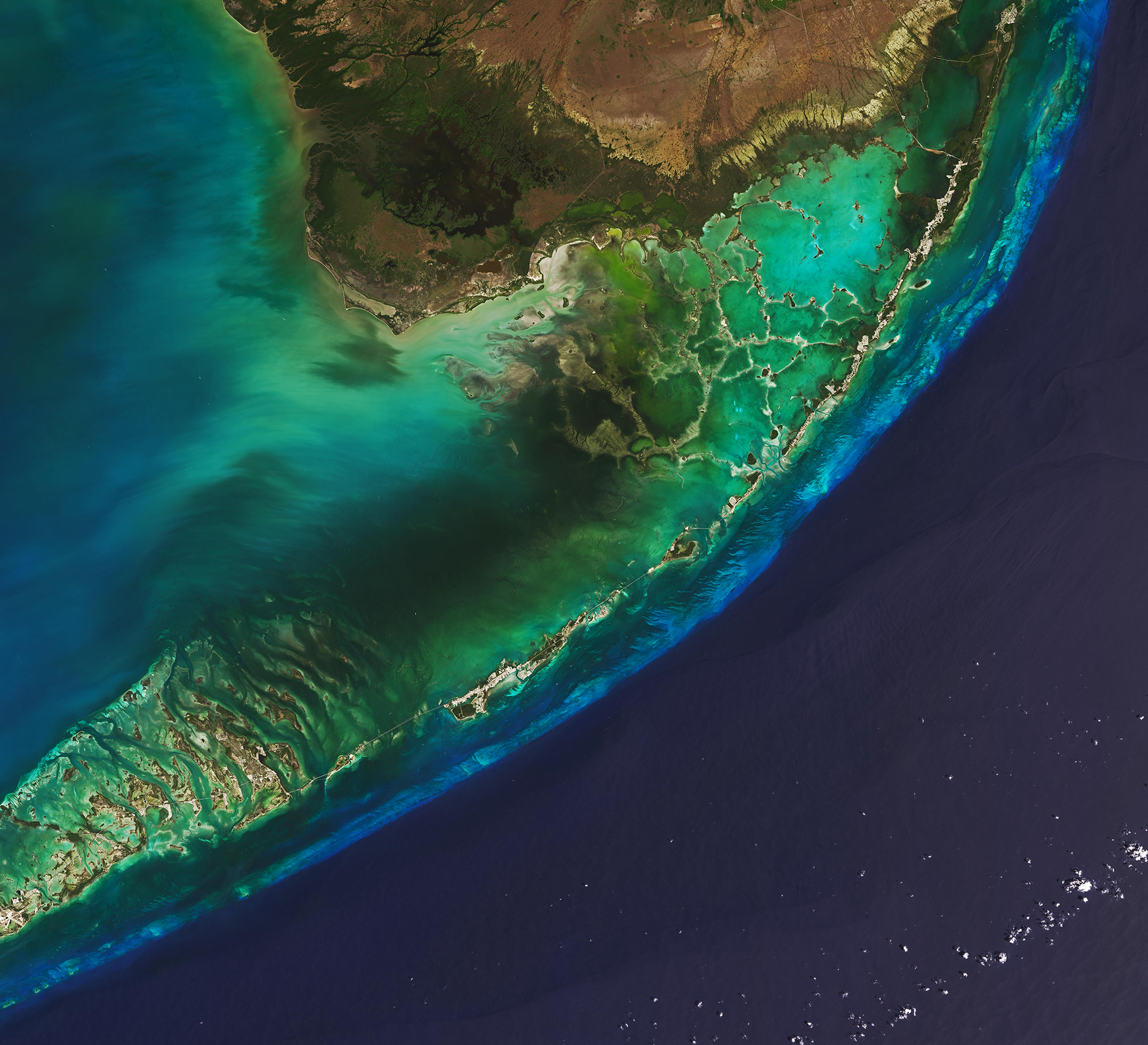
Florida’s Keys


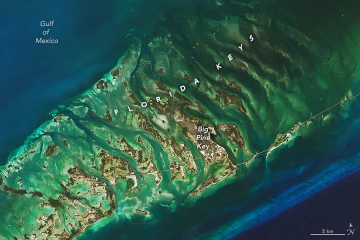
Stretching from the southern tip of Florida, a chain of low-lying islands, known as keys or cays, formed underwater during a warm interglacial period some 125,000 years ago. Originally coral reefs and sand bars, the islands hardened and fossilized when sea levels dropped during an ice age. These natural-color satellite images hint at the keys’ impressive ecosystems. The bright blue streak is a giant coral reef separating the deeper waters of the Atlantic from the shallow waters and sea-grass beds lying between the islands. Formations like these, along with mangrove forests, are part of nature’s way to mitigate the damage and flooding caused by hurricanes. Unfortunately, warmer seas and rising sea levels now threaten the keys. (Image credit: L. Dauphin/USGS; via NASA Earth Observatory)

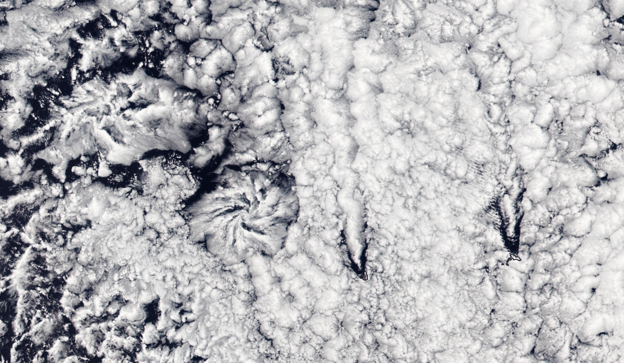
Actinoform Clouds
Flower-shaped actinoform clouds, like those seen on the left side of this satellite image, were only discovered in the 1960s once satellite imagery allowed meteorologists to identify cloud structures that were too large to recognize from the ground. Often appearing over the ocean, these clouds can stretch over hundreds of kilometers, bringing drizzling rain.
This particular set of actinoform clouds have some distinctive neighbors in the right side of the image, where V-shaped slashes through the cloud cover mark the origins of two von Karman vortex streets. The vortex streets appear downwind of two rocky islands, Alejandro Selkirk Island and Robinson Crusoe Island. (Image credit: L. Dauphin; via NASA Earth Observatory)

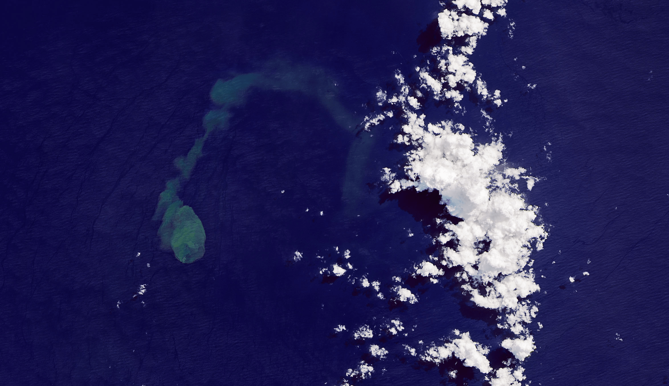
Submarine Eruptions
The green-blue plume on the left of this satellite image is an eruption from Kavachi, an underwater volcano in the Solomon Islands. Kavachi’s crest is currently estimated to lie 20 meters below the surface, with its base at a depth of 1.2 kilometers. Eruptions are quite common at the volcano, but that doesn’t stop wildlife — like hammerhead sharks! — from making the crater their home. Over the last century, Kavachi’s eruptions have repeatedly formed small islands at the surface, but they were quickly eroded away by wave action. (Image credit: J. Stevens/NASA/USGS; via NASA Earth Observatory)

Surf’s Up
Surfers flock to northern Peru to enjoy what’s been called the world’s longest wave. These waves are generated by storms thousands of miles away in the Pacific and Southern Oceans. In the open water between, the waves sort themselves into groups of similar wavelength and speed. With the deep water off Peru, the large swells continue to travel together until close to the shore. Surfers also benefit from the tendency for incoming waves to arrive nearly parallel to the coastline, creating long shoreline stretches for breaking. Where many famous wave breaks can be ridden for seconds, surfers can ride these for minutes! (Image credit: L. Dauphin; via NASA Earth Observatory)

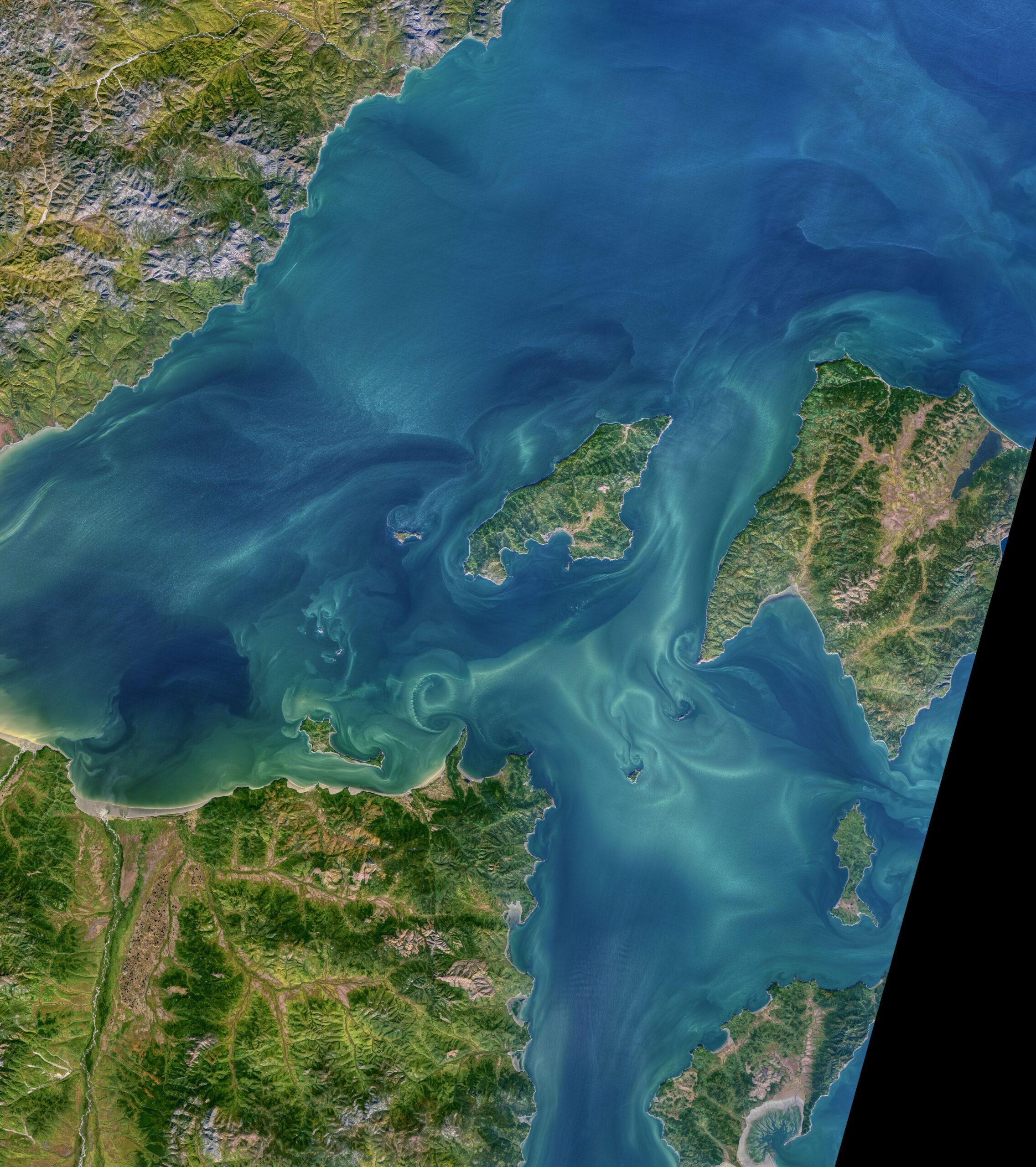
Tidal Vortices
Local topography in the Sea of Okhotsk funnels water to create some of the largest diurnal tides in the world — nearly 14 meters! The currents rushing past islands and outcrops create swirling vortices like the ones seen in this natural-color satellite image. In some places, you can even see multiple vortices, strung together into a von Karman vortex street. At high tide, the vortex streets stretch westward, but at low tide they point east. (Image credit: N. Kuring/NASA/USGS; via NASA Earth Observatory)

Turquoise Eddies
During the summer months, the Barents Sea between Norway and Russia is streaked with blue and teal swirls. These beautiful patterns are the result of a phytoplankton bloom, as viewed by earth-observing satellites (with a little color enhancement). Although each cell in the bloom is only nanometers across, their collective presence is visible from space! They also act as tracers in the water, revealing the swirling flow patterns present there. (Image credit: J. Stevens/NASA Earth Observatory)

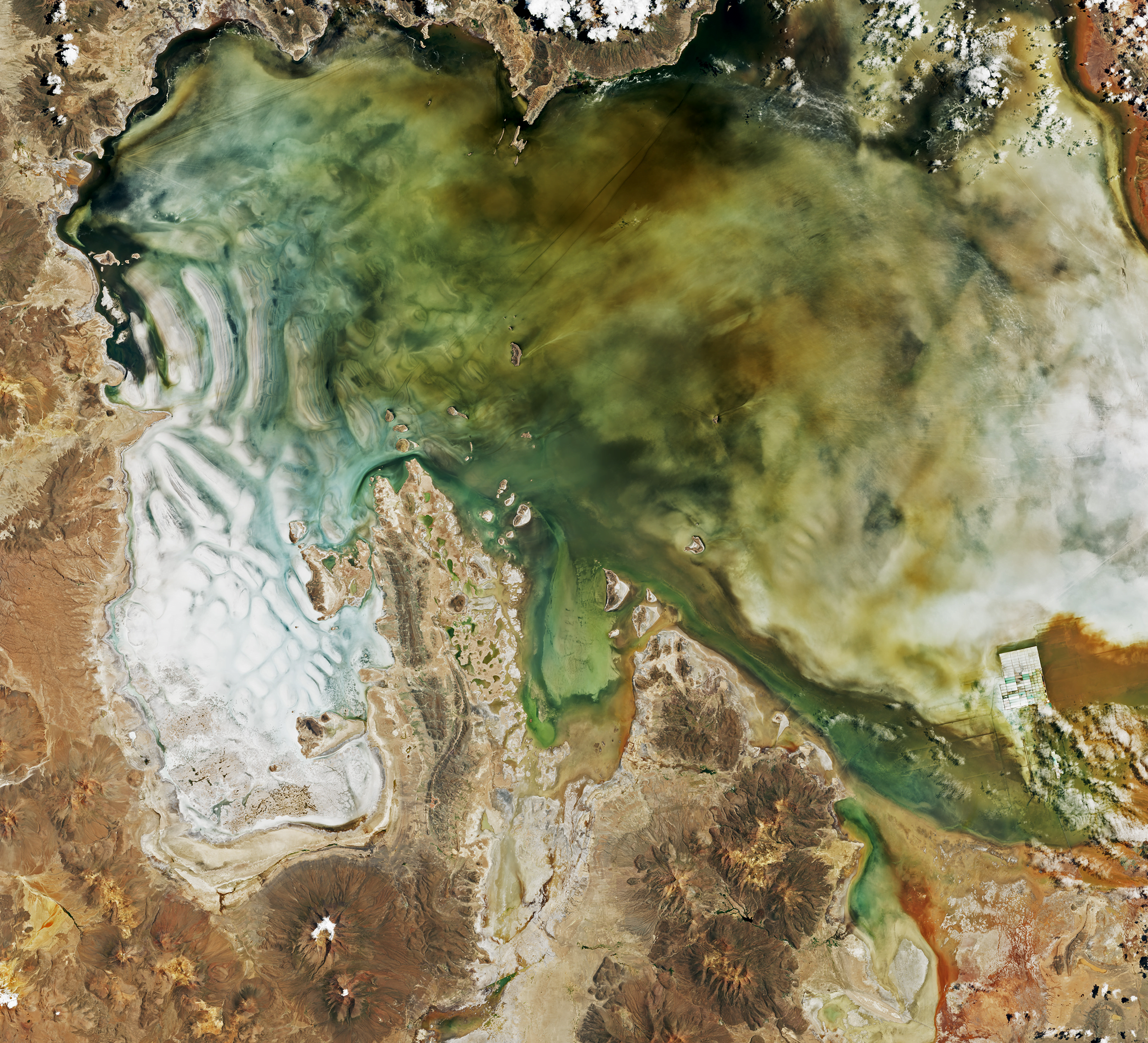
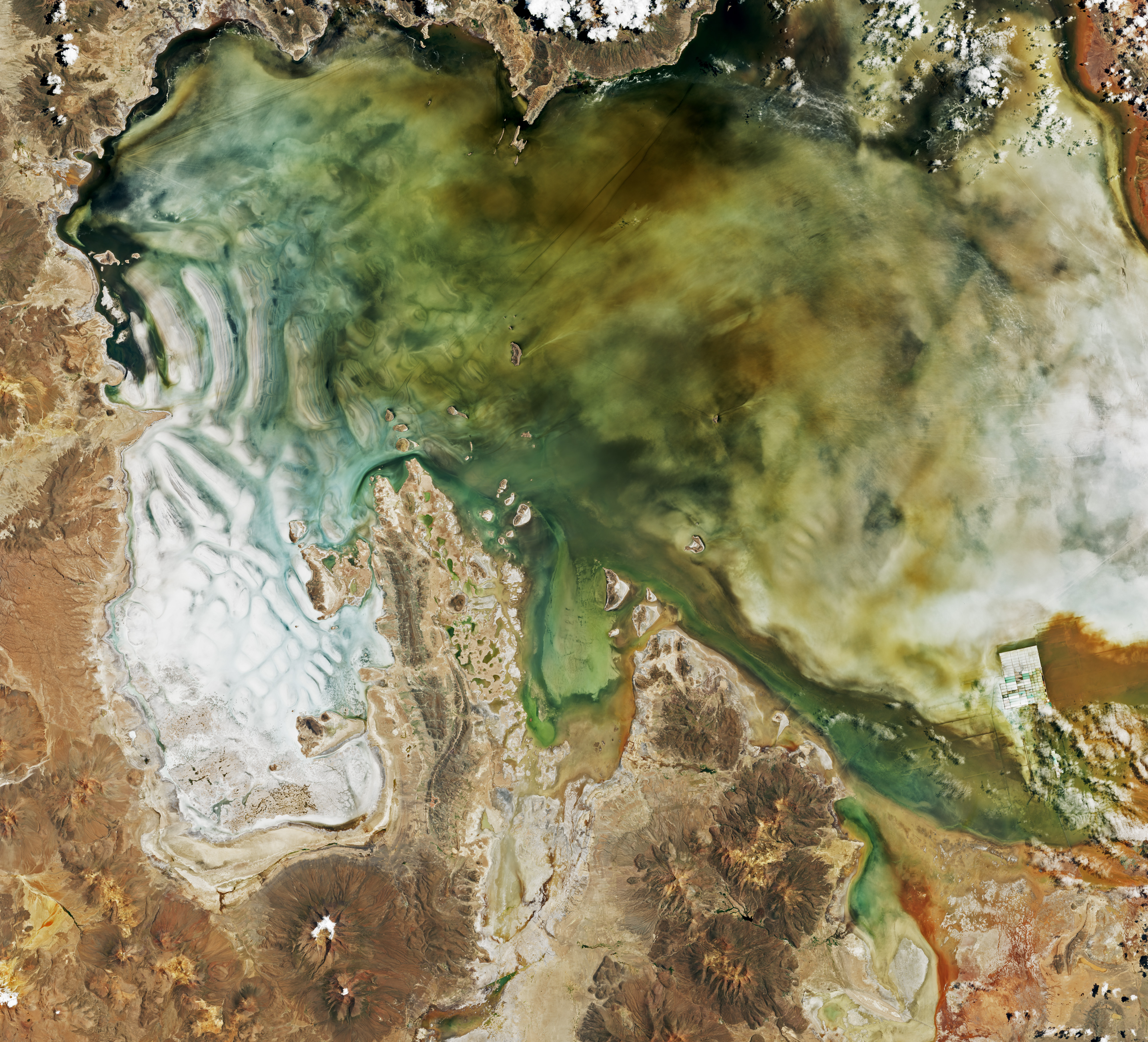
Watery Salt Flats
Unusually high rainfall in Bolivia’s Salar de Uyuni turned the world’s largest salt flat into a shallow salt lake. These natural-color satellite images show the area in late January 2022. If you zoom in on the full resolution image, there are incredible detailed swirls in the water. It’s like peering at an abstract or Impressionist painting. The many colors are attributable to several sources, including volcanic sediments, runoff, and a variety of microbes and algae thriving in the mineral-filled waters. (Image credit: L. Dauphin; via NASA Earth Observatory)

Erie Ice
Lake Erie, the shallowest of the Great Lakes, sees large swings in ice cover over the winter. In late January 2022, the lake was nearly completely frozen over, with 94 percent of its area covered in ice. By February 3rd, ice cover had dropped to 62 percent before rising again to 90 percent by the 5th. Air temperature and wind are the primary drivers of Erie’s fast ice growth and decay. As storms roll through, the ice can spread rapidly, but once temperatures rise, it takes very little forcing from the wind for the ice to begin breaking up. (Image credit: J. Stevens/USGS; via NASA Earth Observatory)


