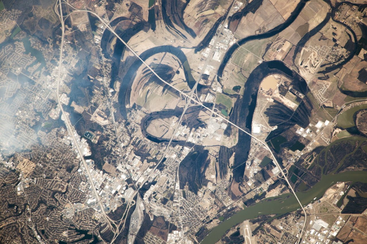
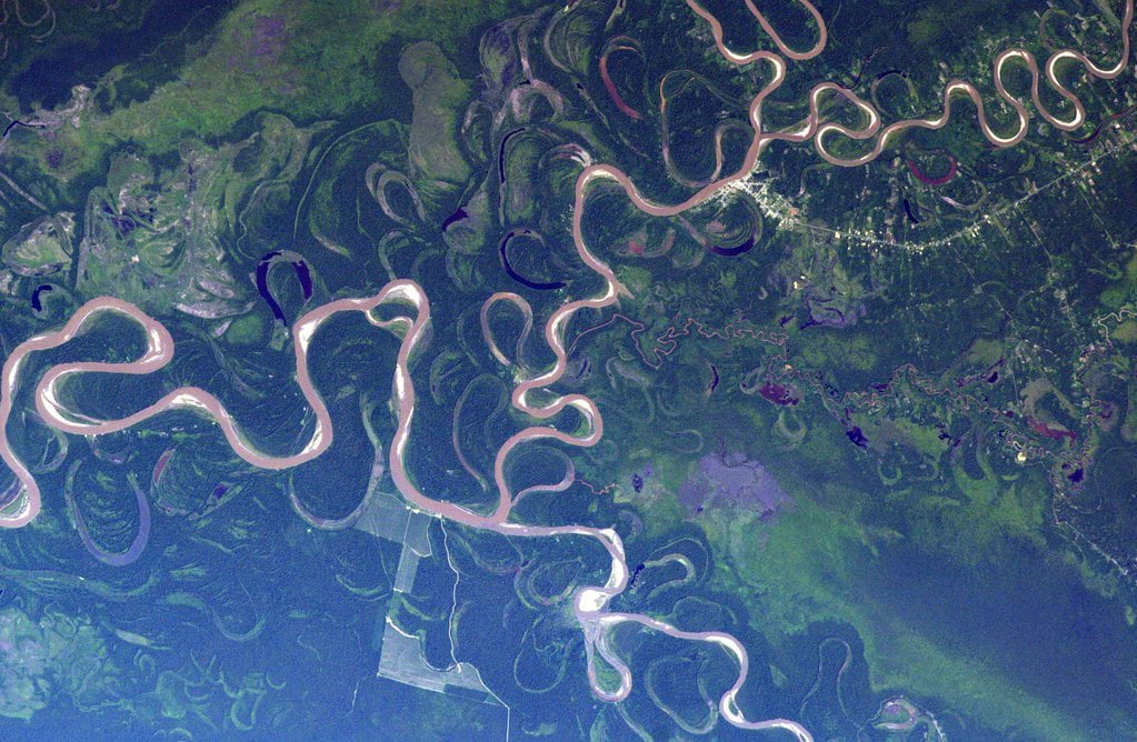
When unconstrained by the local topography, rivers tend to meander, as shown in this astronaut photograph of the Arkansas River near Little Rock, AR. The current course of the river is visible in green in the lower right hand corner of the image, but numerous lakes and curved banks show some of the former paths the river took. When rivers develop a bend, flow is faster on the inner bank than around the outer bank. This speed difference causes a vortical secondary flow inside the river that removes sediment from the outer bank and deposits it on the inner side. The end result is that the bend in the river gets sharper and the river meanders further. Sometimes the bends get so sharp they pinch off, leaving behind lakes. (Photo credit: Exp. 38/NASA Earth Observatory)
Tag: rivers

Freshwater Flux
These satellite images show the effects of a sudden influx of warm freshwater on sea ice in the Arctic Ocean. On the left are natural color satellite images of Canada’s Mackenzie River delta where it enters the Beaufort Sea. On the right are temperature maps of the ice and water surface temperatures for the same regions. In June 2012, the coastal sea ice that had been blocking the river’s delta broke, releasing a massive discharge of river water. The natural color images show brown and tan sediment reaching far out from the river delta, but the temperature maps on the right are even more dramatic. Warmer river water has spread many hundreds of kilometers from the delta, melting sea ice and raising the open water surface temperatures by an average of 6.5 degrees Celsius. The effects of river discharge on sea ice melt are increasing as inland Arctic areas warm more in the summers and the sea ice becomes thinner and more vulnerable each year. (Image credits: NASA Earth Observatory)

North Dakota Ice Disk
Cold weather can create some wild fluid dynamics, so pay attention to your local rivers and waterfalls during the next cold snap. The video above comes from North Dakota where a combination of cold dense air and a stable river eddy created a spinning ice disk, roughly 16 meters in diameter. The disk forms as a collection of ice chunks–not one solid, spinning piece–because the ice formed gradually. As ice pieces form, they get caught in the river eddy and begin to spin as part of the disk, rather like dust and ice do in the rings of Saturn. Such formations are rare but not unheard of; here’s a video showing a similar disk as it grows. (Video credit: G. Loegering; via Yahoo and io9; submitted by Simon H and John C)

Simulating Floods
Last week officials opened the Glen Canyon Dam’s bypass tubes to release a simulated flood on the Colorado River, which runs through the Grand Canyon. This is the first of several planned “high-flows” intended to imitate the positive effects of natural floods on the area. Officials hope the increased water flow will help deposit sediment along the Grand Canyon’s walls at heights unreachable at the lower water levels. This sediment transport should help restore the natural sandbars and beaches that serve as breeding grounds for native fish. The floods will also clear vegetation from the riverside camping spots utilized by tourists. (Photo credit: Reuters/Bob Strong; submitted by Bobby E.)

How to Escape a Whitewater Hole
One of the perils of whitewater sports is getting stuck in what paddlers call a “hole” or a “hydraulic”. This river feature forms just downstream of large obstacles like rocks or low-level dams. As water pours over the obstacle and into its shadow, the flow forms a recirculating vortex-like zone. Immediately next to the obstacle, water is pulled upstream toward the obstacle and then down toward the bottom of the river. This makes the hydraulic very dangerous and hard to escape. Note in the video how the raft is held in place by the upstream motion of the water at the surface of the hydraulic. The rafters are preventing their craft from flipping over by weighing down the side experiencing the upward flow of the vortex. Escaping a hydraulic usually requires getting near its edge, where its current is weaker. If swimming, the best way to escape is to swim toward the bottom of the river and then downstream with the current of the hydraulic rather than against it at the surface.

How Dams Affect Rivers
This video shows how the installation of a dam can affect river flow and sediment transport. Before the dam is added, the flow is shallow and the sediment transport is uniform. The installation of the dam creates deep subcritical flow upstream and supercritical flow downstream. This means that wave information–like ripples–can propagate upstream on the subcritical side; on the supercritical side, the wave velocity is lower than the flow velocity and ripples cannot propagate upstream. This is analogous to sub- and supersonic flow in air. The critical flow over the dam is analogous to a shock wave. The lower velocity upstream of the dam is unable to carry sediment downstream and transport essentially ceases until the sediment builds up to a height where the depth of the water above the dam is roughly equal to that below the dam and sediment transport resumes, scouring the downstream supercritical section. Around 0:40, a gate is closed on the downstream side (off frame), creating a hydraulic jump. In the final section of the video, after sediment has built up on both sides of the dam, the downstream gate is re-opened and the jump reforms as sediment is blown out below the dam. (Video credit: Little River Research and Design, with funding from the Missouri Department of Natural Resources)

River Jumps

Hydraulic jumps occur when a high velocity liquid runs into an area of low velocity liquid. The faster moving liquid decelerates rapidly and increases in height, effectively trading kinetic energy for potential energy. The phenomenon is frequently observed in open channel flow, like in spillways or along rivers, as in the photos above. In nature, the hydraulic jump will often be laminar upstream and turbulent downstream. #

Brazilian Barrier Islands
Barrier islands are in a constant state of flux due to the currents, tides, and winds that surround and shape them. This satellite image of islands off the Brazilian coast shows meandering waterways and the mixing of sediment from the land into the sea. Often, secondary flows are responsible for shaping of these sorts of geographic features. #

Meandering Mississippi
This satellite photo of the Mississippi River south of Memphis, TN shows how the river’s course has changed over time. When a river bends, the water near the inner bank flows faster than the water by the outer bank. This difference in speeds actually creates a vortical secondary flow in the boundary layer of the river that erodes sediment from the outer bank and deposits it on the inner bank. This increases the meander of the river bend. If this continues long enough, the river bend can get pinched off into an oxbow lake, like the ones scattered to either side of the current river path.


