Over time, rivers naturally curve and meander. As water accelerates around a river bend’s curve, it creates a secondary flow that carves sediment away from the outer bank and deposits it on the inner one. That, in turn, makes the river bend sharper until it eventually cuts part of the river off into an oxbow lake. In this astronaut photo, we see the Alabama River flowing right-to-left. The river’s natural meander is constrained by the dam on the center left, which widens the river upstream. The higher water level upstream creates the feather-like floodplains lining the river. (Image credit: NASA; via NASA Earth Observatory)
Tag: meander

Glacial Blues
Meltwater braids like a river delta in this gorgeous image from photographer Stuart Chape. It earned the Silver distinction from the World Nature Photography Awards in their “Planet Earth’s landscapes and environments” category. Water takes tortuous paths like these as it tries to balance the local incline, erosion, deposition, and flow rate. (Image credit: S. Chape/WNPA; via Colossal)

Fediverse Reactions
-

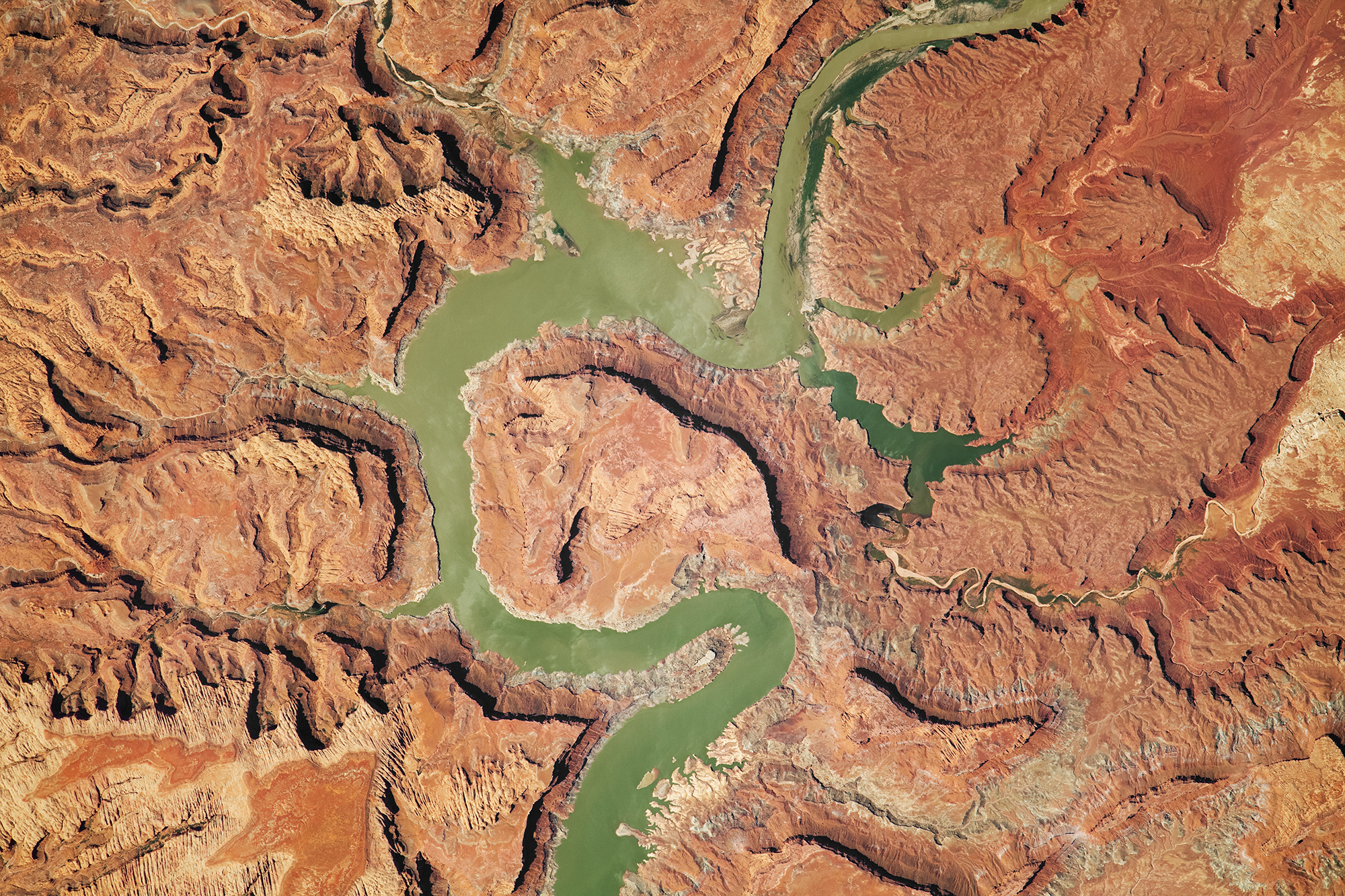
Cutting Out Canyons
Over the millennia, the Colorado River has carved some of the deepest and most dramatic canyons on our planet. This astronaut photo shows the river near its dam at Lake Powell. The strip of white edging the lake is the “bathtub ring” that shows how the water level has varied over the years. The deep canyons — over 400 meters from the Horn in the center of the photo to the river beside it — throw shadows across the landscape. To reach these depths, the Colorado River incised its path into bedrock that was tectonically uplifted. (Image credit: NASA; via NASA Earth Observatory)
Fediverse Reactions
-

“Serenity”


Peering from directly above, landscapes take on a whole different aspect. That idea is the heart of Vadim Sherbakov’s “Serenity,” filmed by drone. From seething waters and meandering rivers to eroded landscapes and twisting ice, there’s lots of fluid dynamics on display here. (Video and image credit: V. Sherbakov)
Fediverse Reactions
-

Langebaan Lagoon
Strands of green and brown mix in Langebaan Lagoon on the South African coast in this astronaut photograph. The shallow tidal estuary has a sandy floor and, since no river flows into it, the deeper green sections seen here are channels carved solely by the back-and-forth flow of the tides. To the north of the lagoon, Saldanha Bay is a busy hub for fishing and industry. The long reddish line extending into the water is a railroad pier responsible for loading 96 percent of South Africa’s iron ore gets loaded onto ships. (Image credit: NASA; via NASA Earth Observatory)

Ghosts of Rivers Past


Artist Dan Coe uses lidar data to create portraits of rivers and their past meanders. Used aerially, lidar produces high-resolution elevation data that provides a glimpse of features that are currently hidden beneath vegetation. With rivers, this means unearthing some of their previous paths. Secondary flows in a river bend erode the bed so that the bend gets more and more strongly curved. Eventually, the river can double back on itself and cut off the long curve. Repeat that process over millennia and you wind up with the complex paths in Coe’s images. (Image credit: D. Coe; via Colossal)
Why Rivers Shift


In their natural state, rivers are variable in their course, shifting and meandering. Sometimes they deposit sediment, and sometimes they erode it. In this video, Grady from Practical Engineering digs into the principles behind these changes. With help from Emriver‘s stream tables, which demonstrate years of changes in a river over minutes, Grady shows how changing the sediment load, flow rate, and other factors in a river affect its course. (Video credit: Practical Engineering)
Siberia’s Lena River Delta
As rivers near the sea, they often slow down and branch out, creating intricate paths through delta wetlands. This video explores the Arctic’s largest river delta, that of the Lena River in Siberia, during its spring and summer flood season. The images were all taken by satellite and processed with color enhancements to highlight patterns in the water. Although this is not quite how the area would appear by eye, all of the visible patterns are real. (Image credit: N. Kuring/NASA’s Ocean Color Web; video credit: K. Hansen; via NASA Earth Observatory)


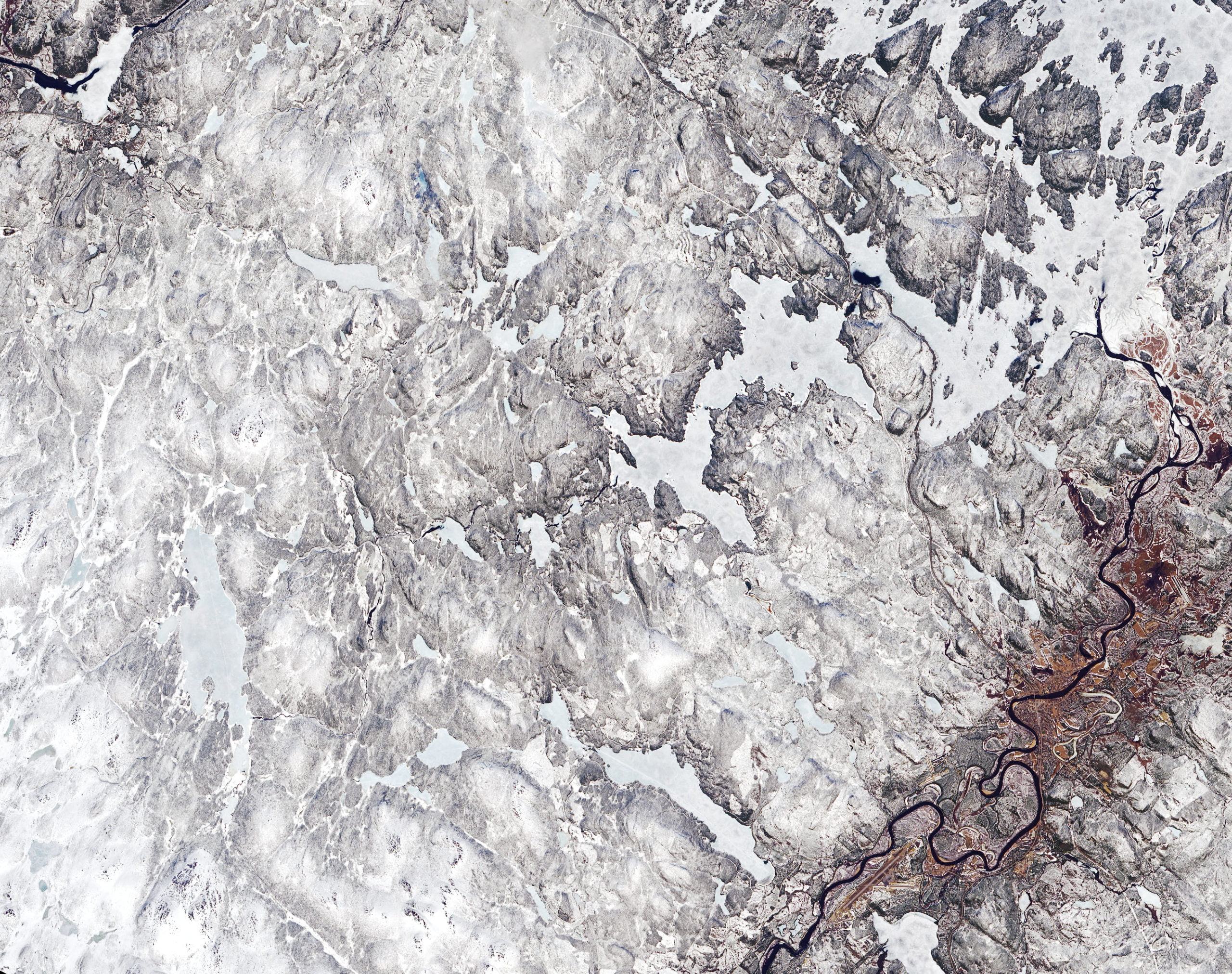
Meandering
The banks of rivers are in constant flux, a pattern most easily captured from above. This satellite image shows a section of the Ivalo River in Finland, swollen with snowmelt after a winter of historic snowfalls. From above we see some of the river’s previous paths. This meandering is a natural result of secondary flows where rivers bend. The water carves away sediment from the outer bank and deposits it on the inner one, exaggerating every curve until the river cuts itself off, leaving behind a sinuous lake detached from the river’s new course. For an interesting (though non-physical) look at meandering, check out this procedural system for generating maps of rivers (thanks to Kam-Yung Soh for sharing). (Image credit: J. Stevens; via NASA Earth Observatory)

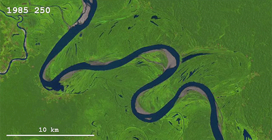
Forming an Oxbow
Without human intervention, meandering rivers become more sinuous over time. This is driven by the flow around a river bend, which tends to push sediment from the outer bank of the curve to the inner, making the bend more pronounced. Eventually, loops in the river can pinch off and form a separate oxbow lake, as seen in the animation above and video below.
By studying many photo sequences like this one, researchers have concluded that how quickly a river bend meanders depends on its curvature. In general, the higher the curvature, the faster the river bend will migrate. When rivers deviate from this rule of thumb, it’s typically because part of a river bank is tougher to erode than other sections. (Image and video credit: Z. Sylvester/Geolounge; research credit: Z. Sylvester; via Landsat; submitted by Aatish B.)


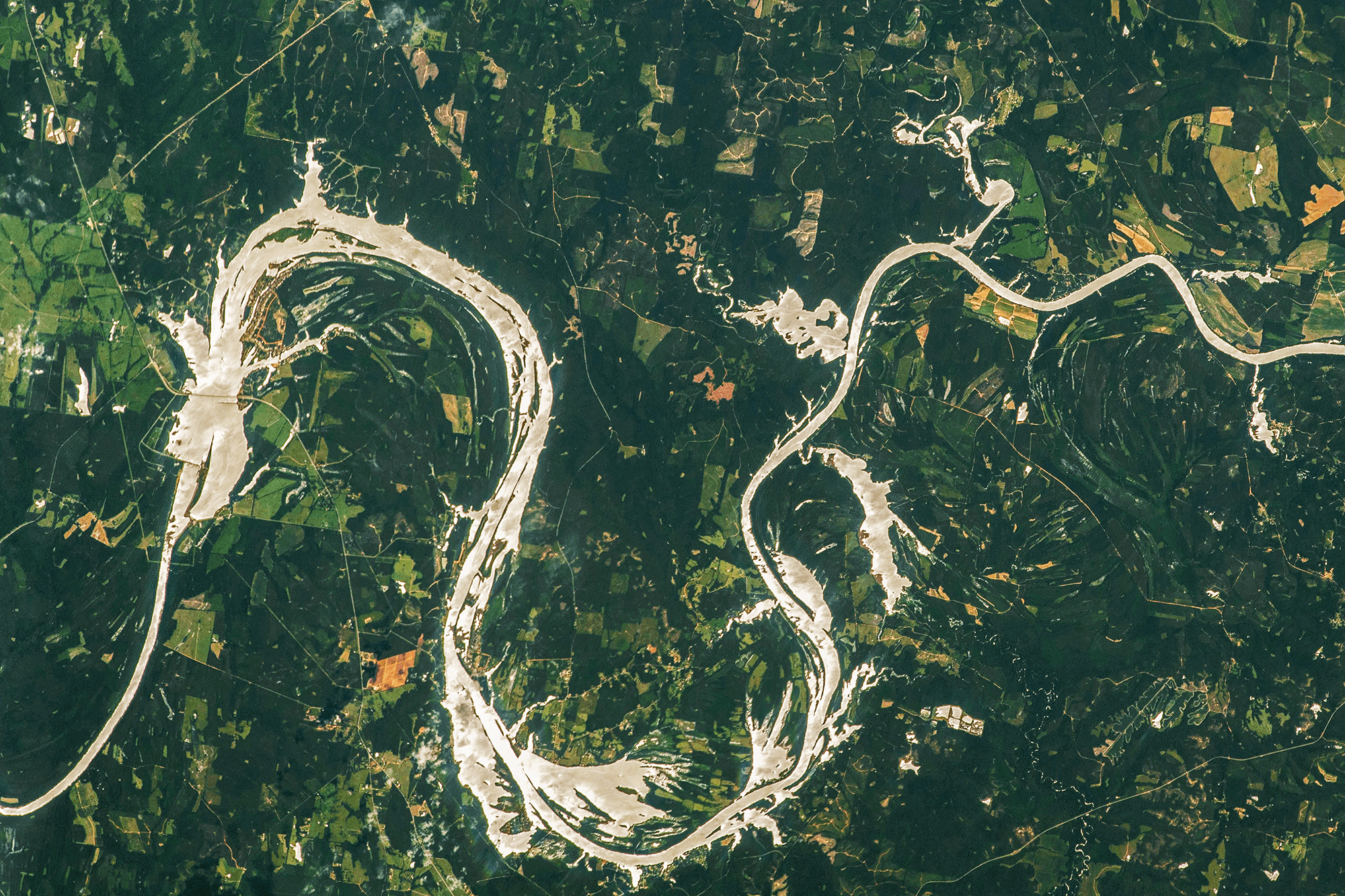
 floodplain near Szczucin, Poland.")