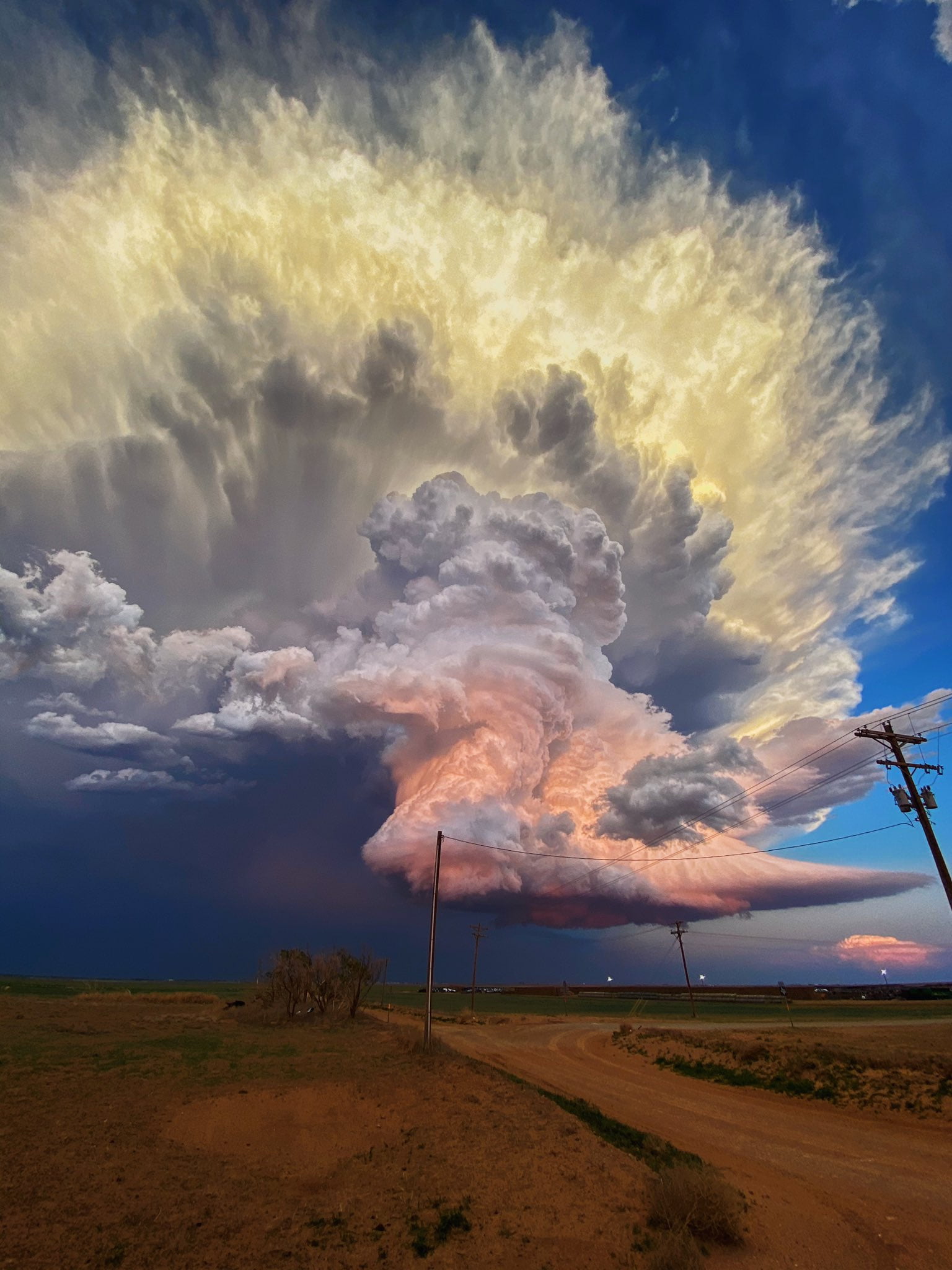
There’s nothing quite like a towering storm cloud to showcase nature’s power. This gorgeous photo by Laura Rowe shows pastel clouds over West Texas in the middle of a thunderstorm. Despite the dusk at ground level, the height of the cloud keeps it lit by direct sunlight, giving its turbulent convection that colorful glow. Rowe, as it happens, is not a professional photographer, which is a good reminder to us all: it’s always worth looking up! You never know what beauty you’ll miss if you don’t. (Image credit: L. Rowe; via Colossal)
Tag: clouds

Chasing the Storm
.")
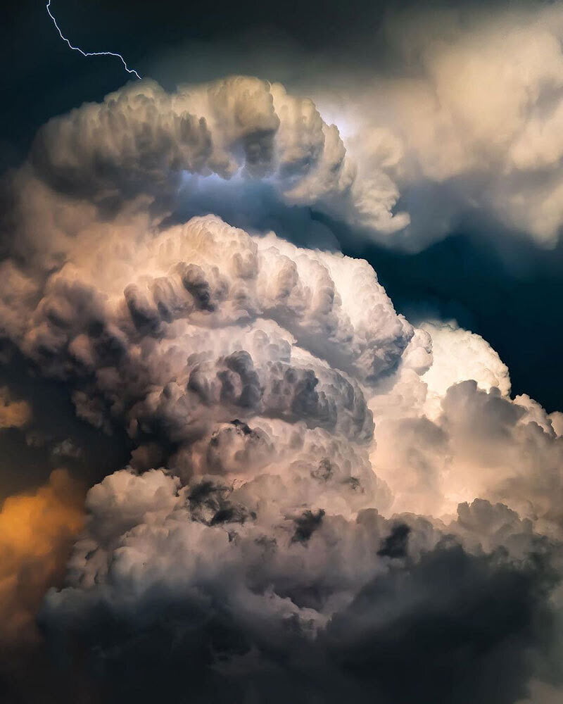


Towering mountains of convection and ominous colors are staples of Adam Kyle Jackson’s storm photography. His dramatic portraits of supercell thunderstorms highlight the majesty and power of these turbulent phenomena. Make sure to follow him on Instagram for lots more! (Image credit: A. Jackson; via Nat Geo)

Fallstreak Holes


Occasionally clouds appear to have a hole in them; these are known as fallstreak holes or hole-punch clouds. To form, the water droplets in the cloud must be supercooled; in other words, they must be colder than their freezing point but still in liquid form. When disturbed — say, by the temperature drop caused by flowing over an airplane wing — the supercooled water droplets will suddenly freeze. This typically kicks off a chain reaction in which many droplets freeze and the heavy ice crystals fall out of the sky, leaving behind a void in the cloud. Because airplanes are particularly good at creating these fallstreak holes, they’re often seen near busy airports. (Image credit: J. Stevens/NASA; via NASA Earth Observatory)

Spiderwebs and Stratocumulus Clouds


Stratocumulus clouds cover about 20% of Earth’s surface at any given time, and they form distinctive patterns of lumpy cells separated by thin slits. Because of their interconnectedness, researchers nicknamed these narrow regions spiderwebs. New simulations show that evaporative cooling along the cloud tops drives the formation of these spiderwebs (Image 2). Without it (Image 3), the cloud pattern looks very different. (Image credits: featured image – L. Dauphin/MODIS, others – UConn ME 3250; research credit: G. Matheou et al.)

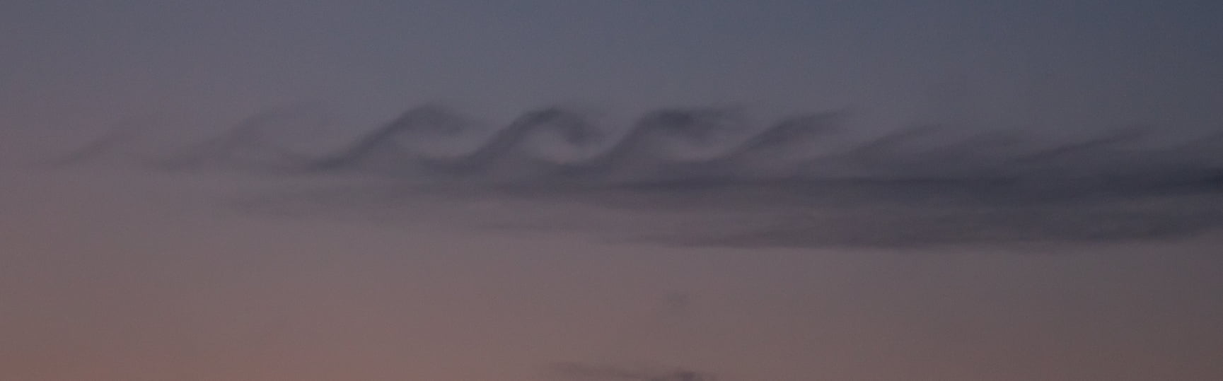
Sunset Swirls
This gorgeous photograph of Kelvin-Helmholtz clouds was taken in late December in Slovenia by Gregor Riačevič. The wave-like shape of the Kelvin-Helmholtz instability comes from shear between two fluid layers moving at different relative speeds. Here on Earth, clouds like these are often short-lived, but we see similar structures in the atmospheres of gas giants like Jupiter and Saturn. (Image credit: G. Riačevič; submitted by Matevz D.)

Colorful Kelvin-Helmholtz Clouds
Like breaking waves at the beach, these wavy clouds curl but only for a moment. The photo was captured near sunset on a late August evening in Arlington, MA. This short-lived cloud shape forms due to the Kelvin-Helmholtz instability, which is driven by shear forces between two layers of air moving at different speeds. The situation is a common one in the atmosphere, where air layers at altitude move in different directions and at different speeds. Most of the time we cannot see the curls that form between these air layers because of air’s transparency. But occasionally the mismatch happens right at a cloud layer and the condensation of the cloud gets pulled into these distinctive curls. (Image credit: B. Bray; submitted by Mark S.)

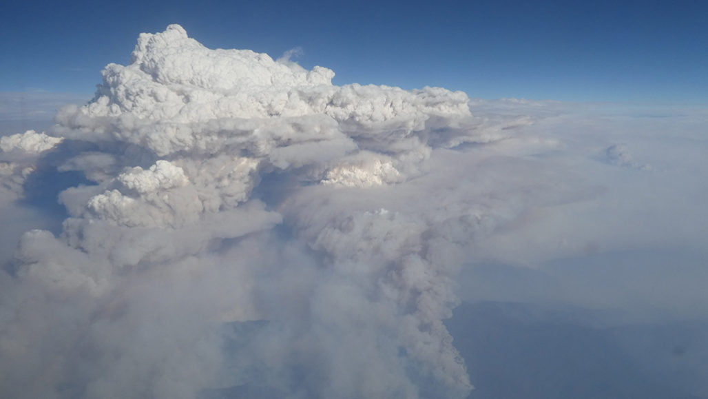
Stratospheric Effects of Wildfires
Australia’s bushfires from earlier this year are offering new insights into how pyrocumulonimbus clouds can affect our stratosphere. A massive, uncontrolled blaze between December 29th and January 4th generated a towering, turbulent cloud of smoke like the one shown above.
Using meteorological data, a new study shows this enormous cloud initially rose to 16 km in altitude, then began a months-long trek that circled the globe. The smoke plume ultimately stretched to over 1,000 km wide and reached a record altitude of over 31 km. Inside the plume, concentrations of water vapor and carbon monoxide were several hundred percent higher than normal stratospheric air.
Researchers found the plume extremely slow to dissipate, possibly due to strong rotational winds surrounding it. This is the first time scientists have observed these shielding winds, and work is still underway to determine how and why they formed. (Image credit: M. Macleod/Wikimedia Commons; research credit: G. Kablick III et al.; via Science News; submitted by Kam-Yung Soh)

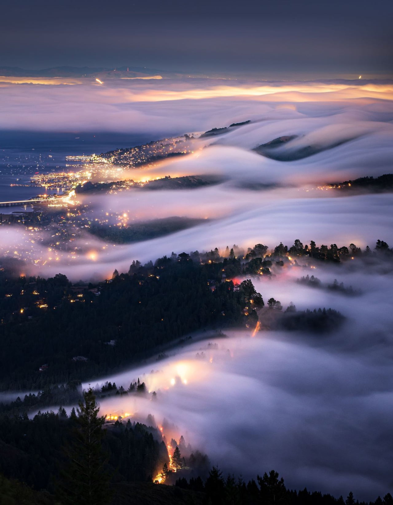
As the Fog Rolls In
Although we talk about fog rolling in, it’s rare for us to have a perspective where we can truly appreciate that flow. But this photograph from Tanmay Sapkal provides just that for the low summer fogs sweeping over Marin, CA. When hot summer temperatures make inland air rise, cold, moist air from the ocean sweeps in to replace it. Once the moisture condenses, it forms thick, low clouds of fog that surge past the Golden Gate Bridge and into San Francisco Bay. (Image credit: T. Sapkal; via NatGeo)
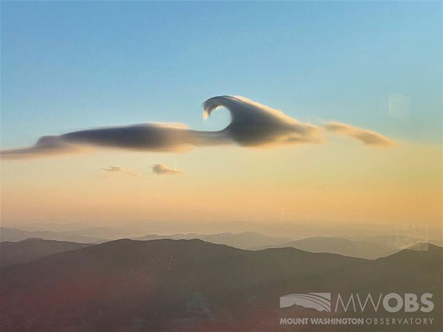
A Lenticular Cloud With a Curl
Lens-shaped lenticular clouds are not terribly rare in mountainous areas, but observers at Mount Washington caught a very unusual cloud near sunrise in late February. This lenticular cloud had an added curl on top thanks to the Kelvin-Helmholtz instability!
Lenticular clouds form when air is forced to flow up over a mountain in such a way that its temperature and pressure drop and water vapor in the air condenses. The resulting water droplets form a cloud that appears stationary over the mountain, even though the air continues to flow.
To get that added wave-like curl, there needs to be another, faster-moving layer of air just above the cloud. As that air flows past, it shears the cloud layer, causing the interface to curl. Neither of these cloud types is long-lived — Kelvin-Helmholtz formations often last only a few minutes — so catching such a great dual example is lucky, indeed! (Image credit: Mount Washington Observatory; via Smithsonian Magazine; submitted by Kam-Yung Soh)

A Year From Geostationary Orbit
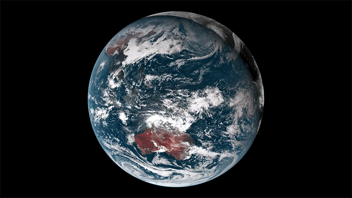

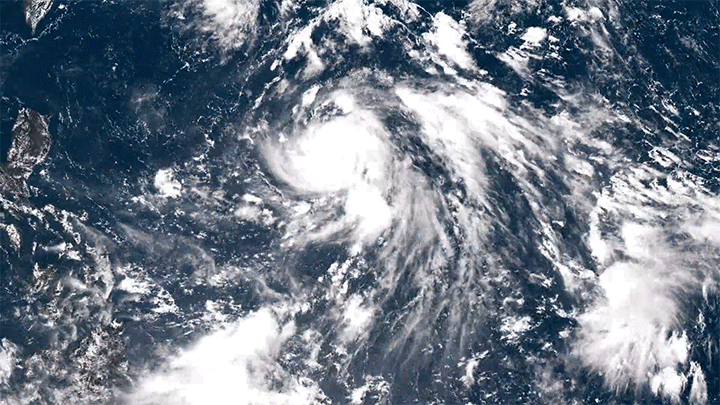
Our planet is a complex fluid dynamical system, and one of the best ways to watch nature at work is through timelapse. This short film takes us through an entire year, from December 2015 to December 2016, as viewed from a geostationary weather satellite centered over Oceania.
The imagery is rather hypnotic, with clouds swirling day and night across the full field of view. Watch closely, though, and you’ll see a lot of neat phenomena from typhoons forming in the Pacific to wave clouds streaming from the islands of Japan. You can also see clouds blossoming (especially during the day) over the humid rainforests of Oceania.
There are neat non-fluids phenomena, too, like a total solar eclipse and the permanent sunlight of Arctic and Antarctic summers. What do you notice? (Image and video credit: F. Dierich)

.")
.")
.")
.")


