Tag: clouds

  • Cellular Clouds

    Cellular Clouds

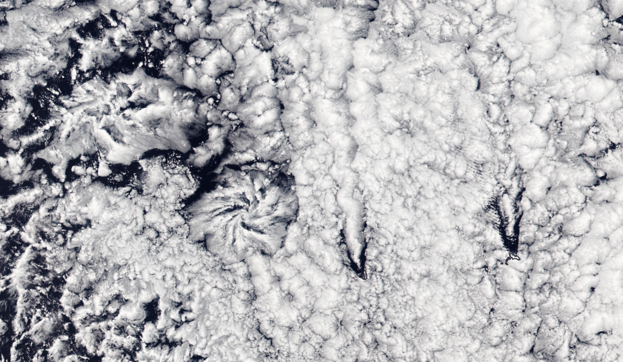
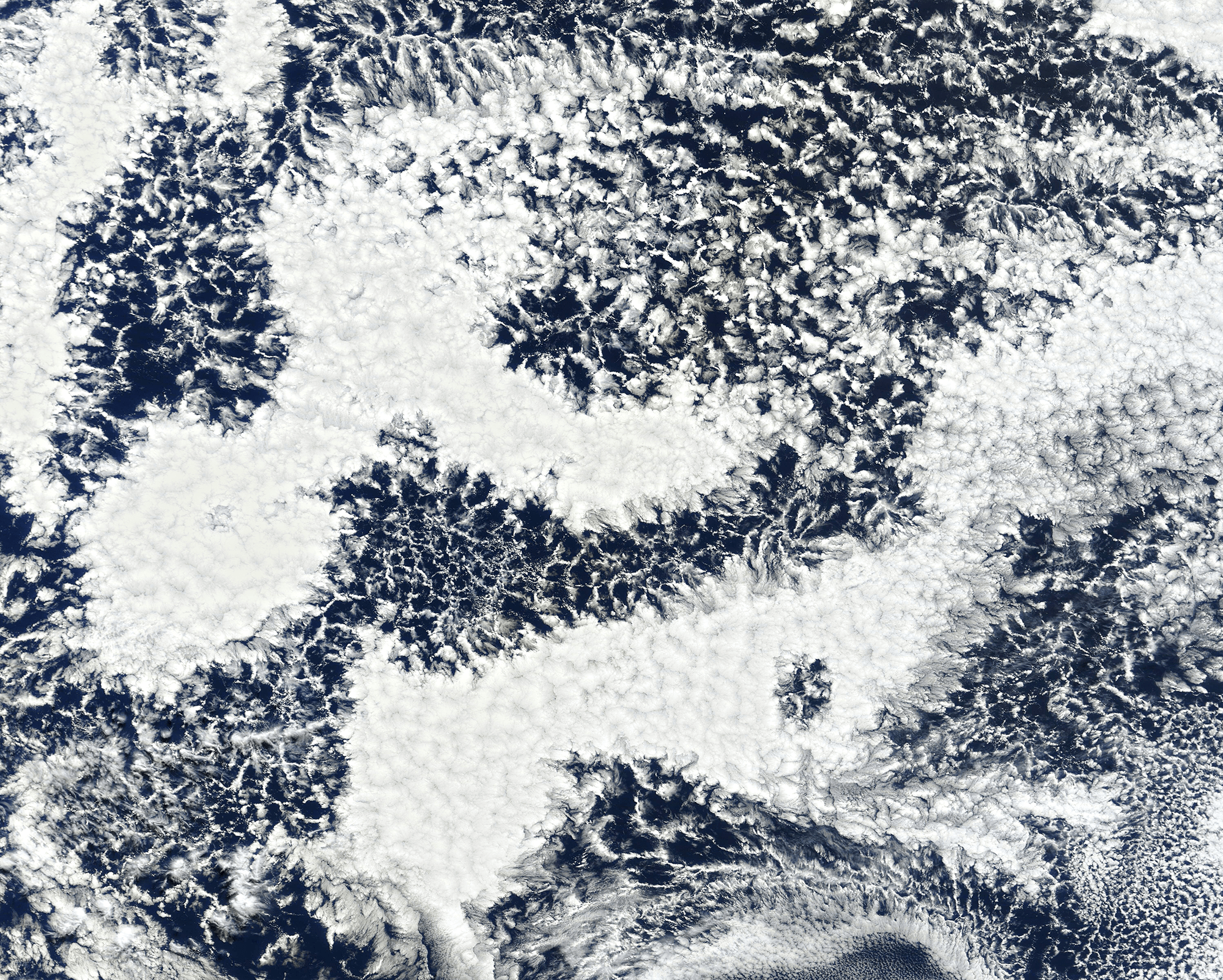
    Though tough to make out from the surface, our oceans are often covered by cell-shaped clouds stretching thousands of kilometers. This satellite image shows off two such types of marine stratocumulus cloud. Open-celled clouds appear as thin wisps of vapor around an empty middle; in these clouds, cool air sinks through the center while warm air rises along the edges. Open-celled clouds are good rain producers.

    On the flip side, closed-cell clouds have a vapor-filled center and breaks in the cloud cover along each cell’s edge. These clouds don’t produce much rain, but they do lift warm, moist air through their middles and let cool air sink along their edges. Closed-cell clouds tend to last much longer than their open-celled counterparts; they can stick around for half a day, whereas open-celled clouds break up in only a couple hours. (Image credit: J. Stevens; via NASA Earth Observatory)

  • Jupiter’s Frosted Clouds

    Jupiter’s Frosted Clouds

    This 3D rendering of Jupiter's cloud tops is based on flyby data from the JunoCam instrument. It's not a true physical image of the cloud tops, though scientists are working on a calibration for that. Instead, the elevations shown here are based on the intensity of visible light registered by the instrument. This measure correlates with cloud height, but there are exceptions.
    This 3D rendering of Jupiter’s cloud tops is based on flyby data from the JunoCam instrument. It’s not a true physical image of the cloud tops, though scientists are working on a calibration for that. Instead, the elevations shown here are based on the intensity of visible light registered by the instrument. This measure correlates with cloud height, but there are exceptions.

    New 3D renderings of Jovian clouds show textured swirls akin to a cupcake’s sculpted frosting. The images are based on flyby data from the JunoCam instrument. Because illumination of the clouds is generally brightest for the highest clouds, the team has rendered elevation based on brightest. While this is somewhat physical, it’s not exactly what Jupiter looks like. For that, Juno scientists are working on a calibration that will translate these initial renderings into a truer physical model. Nevertheless, the results are stunning, especially the flyover video embedded over here! (Image credit: 3D renders – NASA / JPL-Caltech / SwRI / MSSS / G. Eichstädt, image pair – G. Eichstädt et al.; via phys.org; submitted by Kam-Yung Soh)

    Cross your eyes to see this image pair as a 3D image of Jupiter's cloud tops.
    Cross your eyes to see this image pair as a 3D image of Jupiter’s cloud tops. The brighter regions will appear closer than the darker ones.
  • Jupiter in Infrared

    Jupiter in Infrared

    These recent composite images from the James Webb Space Telescope show Jupiter in stunning infrared detail. They’re the result of several images taken in different infrared bands, then combined and rendered in visible light. In general, the redder colors show longer wavelengths and the bluer ones show shorter wavelengths.

    Jupiter’s cloud bands appear in beautiful detail. The Great Red Spot looks white in infrared. And the planet’s polar auroras shine bright in both images. The wide-angle shot additionally shows two of Jupiter’s moons and the planet’s rings, which are a million times fainter than the planet itself. If you look carefully, you may also see faint points of light in the lower half of the image. These are likely distant galaxies “photobombing” Jupiter’s close-up. (Image credit: NASA/ESA/Jupiter ERS Team 1, 2; via Colossal)

    This composite image of Jupiter was taken in infrared bands and rendered into visible light. In general, the redder colors represent longer wavelengths and bluer ones shorter wavelengths.
    This composite image of Jupiter was taken in infrared bands and rendered into visible light. In general, the redder colors represent longer wavelengths and bluer ones shorter wavelengths.
  • Actinoform Clouds

    Actinoform Clouds

    Flower-shaped actinoform clouds, like those seen on the left side of this satellite image, were only discovered in the 1960s once satellite imagery allowed meteorologists to identify cloud structures that were too large to recognize from the ground. Often appearing over the ocean, these clouds can stretch over hundreds of kilometers, bringing drizzling rain.

    This particular set of actinoform clouds have some distinctive neighbors in the right side of the image, where V-shaped slashes through the cloud cover mark the origins of two von Karman vortex streets. The vortex streets appear downwind of two rocky islands, Alejandro Selkirk Island and Robinson Crusoe Island. (Image credit: L. Dauphin; via NASA Earth Observatory)

  • Asperitas Formation

    Asperitas Formation

    In 2017, the World Meteorological Organization named a new cloud type: the wave-like asperitas cloud. How these rare and distinctive clouds form is still a matter of debate, but this new study suggests that they need conditions similar to those that produce mammatus clouds, plus some added shear.

    Using direct numerical simulations, the authors studied a moisture-filled cloud layer sitting above drier ambient air. Without shear, large droplets in this cloud layer slowly settle downward. As the droplets evaporate, they cool the area just below the cloud, changing the density and creating a Rayleigh-Taylor-like instability. This is one proposed mechanism for mammatus clouds, which have bulbous shapes that sink down from the cloud.

    When they added shear to the simulation, the authors found that instead of mammatus clouds, they observed asperitas ones. But the amount of shear had to be just right. Too little shear produced mammatus clouds; too much and the shear smeared out the sinking lobes before they could form asperitas waves. (Image credit: A. Beatson; research credit: S. Ravichandran and R. Govindarajan)

  • Sunrise Cloudscape

    Sunrise Cloudscape

    With the low sun angle of dawn, the details of this cloudscape stand out. Captured by an external camera on the International Space Station, this image shows cloud formations over the northwest Atlantic. In the foreground, towering cumuli mark rising plumes of warm, moist air evaporating from the ocean. Beyond those clouds, a flat anvil cloud spreads horizontally after a temperature inversion prevented it from rising any further. (Image credit: NASA; via NASA Earth Observatory)

  • Ship Tracks in the Sky

    Ship Tracks in the Sky

    Line-like clouds criss-cross the Pacific Ocean in this satellite image. Each one is a ship track, a remnant left behind a passing ship. As they travel, ships leave a trail of exhaust that seeds the atmosphere with aerosols that serve as additional nucleation sites for clouds. The tiny particles interact with existing low-level clouds, making them brighter. Of course, the aerosols are present in the wake of ships regardless of whether they seed clouds that we can observe. (Image credit: J. Stevens; via NASA Earth Observatory)

  • Stormy Landscapes

    Stormy Landscapes

    Photographer Mitch Dobrowner captures the power of major storm systems across the western United States and Canada in these dramatic black-and-white images. Misty clouds, massive downpours, bulbous mammatus clouds, and lonely landscapes abound. You can find more of his work on his website and Instagram. (Image credit: M. Dobrowner; via Colossal)

  • Bullseye

    Bullseye

    The Cumbre Vieja volcano in the Canary Islands began erupting in mid-September 2021. This satellite image, captured October 1st, shows a peculiar bullseye-like cloud over the volcano. Hot water vapor and exhaust gases rose rapidly from the erupting volcano until colliding with a drier, warmer air layer at an altitude of 5.3 kilometers. The warm upper layer, known as a temperature inversion, prevented the volcanic gases from rising any further, so they instead spread horizontally. The outflow from the volcano varies and is non-uniform, and its fluctuations generated gravity waves that are visible here as the expanding rings of clouds. (Image credit: L. Dauphin; via NASA Earth Observatory)

  • Noctilucent Clouds

    Noctilucent Clouds

    Noctilucent clouds are the “highest, driest, coldest, and rarest clouds on Earth.” Formed in the mesosphere at altitudes over 80 kilometers, these clouds typically form at polar latitudes where they can catch sunlight hours after sunset, hence their night-shining name. The clouds take shape when water vapor in cold mesospheric air layers freezes onto dust left behind by meteors.

    Fun fact: because of their high altitude and particle size and density, noctilucent clouds were considered a hazard for space shuttle reentry, and planners explicitly avoided trajectories that would take the spacecraft near potential clouds. (Image credit: top – N. Fewings, other – J. Stevens/NASA Earth Observatory)

    Satellite image of noctilucent clouds above the North Pole.