The Juno spacecraft continues to send back incredible photos of Jupiter’s atmosphere. This video animates images from the sixth close pass of Jupiter to give you a sense of what Juno sees as it swoops by our system’s largest planet. The trajectory passes from the north pole to the south, showing Jupiter’s whitish zones, dark belts, and massive storms. Up close Jupiter looks like an Impressionist painting, all vortices and shear instabilities. The large white spots you see are enormous counterclockwise rotating vortices known as anticyclones – many of them larger than our entire planet. (Video credit: NASA / SwRI / MSSS / G. Eichstädt / S. Doran)
Tag: Kelvin-Helmholtz instability

Breaking Waves in the Sky
Under the right atmospheric conditions, clouds can form in a distinctive but short-lived breaking wave pattern known as a Kelvin-Helmholtz cloud. The animation above shows the formation and breakdown of such a cloud over the course of 9 minutes early one morning in Colorado’s Front Range region. Kelvin-Helmholtz instabilities occur when fluid layers with different velocities and/or densities move past one another. Friction between the two layers moving past creates shear and causes the curling rolls seen above.
In the background, you can also see a foehn wall cloud low to the horizon. This type of cloud forms downwind of the Rocky Mountains after warm, moist Chinook winds are forced up over the mountains, cool, and then condense and sink in the mountains’ wake. (Image credit and submission: J. Straccia, more info)

The Perseus Cluster’s Bay


The Perseus cluster is a group of galaxies in the constellation Perseus. When viewed in x-ray, the cluster includes a concave feature known as the “bay”, shown in the white oval of the upper left image. A recent study uses x-ray and radio observations and computer simulations to argue that this feature is, in fact, a Kelvin-Helmholtz wave, like the breaking wave clouds that appear here on Earth.
The simulations start with a cluster similar to Perseus, with a “cold” core of gas about 30 million degrees Celsius and an outer gas region about three times hotter. A second galaxy cluster moves by, just grazing Perseus, and sets its cold gas to sloshing in an expanding spiral. After about 2.5 billion years, the difference in velocity between the cold and hot gases results in a Kelvin-Helmholtz wave near the outer arm of the spiral. One such simulation is shown in the upper right. The Kelvin-Helmholtz wave forms near the end of the cycle at a roughly 2 o’clock position.
If the bay is, in fact, a Kelvin-Helmholtz roll, then this is fluid dynamics on an almost unimaginable scale. That wave is about 160 thousand light-years across! (Image credits: Perseus cluster and movie – Chandra X-Ray Observatory; simulation – John ZuHone/Harvard-Smithsonian Center for Astrophysics; research credit: S. Walker et al.; via Vince D.)

Wrinkling Winds

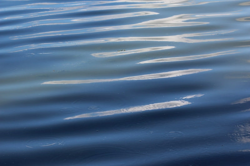
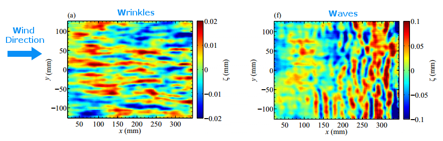
If you’ve ever sat out on a lake and just watched the water’s surface, you’ve probably noticed how complex and variable it looks. There may be waves that rock your kayak but there are smaller variations, too, like little ripples or even tiny wrinkles that appear on the surface. Much of this activity comes from wind blowing across the water. When the wind exceeds a critical speed, waves form. They generally travel in lines that are aligned perpendicular to the wind (lower right). But what happens when the wind is below the critical speed?
A recent study looked at just this question. By blowing air across the surface of different liquids and observing variations in the surface height as small as 2 micrometers, the researchers were able to measure tiny wrinkles on the water’s surface (lower left) when the wind speed was small. The size and shape of the wrinkles actually corresponds to structures in the turbulent air flow over the water! For fluids like water, there’s a smooth transition from wrinkles to waves as the wind speed increases, so both may be visible at the same time. For higher viscosity fluids, the switch from one to the other is more abrupt. (Image credits: water – M. Soveran; figure – A. Paquier et al. w/ annotations added in blue; research credit: A. Paquier et al.)

Vortex Impact
When a vortex ring impacts a solid wall (or a mirrored vortex ring), it expands and quickly breaks up. The animations above show something a little different: what happens when a vortex ring hits a water-air interface. As seen in the side view (top image), the vortex starts to expand, but its shear at the interface generates a stream of smaller vortices that disrupt the larger vortex. (They even look like a little string of Kelvin-Helmholtz vortices!) When viewed from above (bottom image), the vortex ring impact and breakdown look even more complicated. Mushroom-like structures get spat out the sides as those secondary vortices form, and the entire structure quickly breaks up into utter turbulence. There’s some remarkable visual similarities between this situation and some we’ve seen before, like a sphere meeting a wall and drop hitting a pool. (Image credit: A. Benusiglio et al., source)

Weather Posters


Weather Underground has created a whole series of posters celebrating and briefly explaining various weather phenomena. Many of their subjects are beautiful and unusual types of clouds like the lenticular clouds that form over mountains and hole-punch clouds created when supercooled water vapor gets disturbed. They have a few non-cloud phenomena we’ve discussed previously, too, such as dust devils and bizarre, wind-formed snow rollers. I highly encourage you to check out the full collection, which they’ve made available as phone and computer wallpapers as well as posters. Personally, these combine two of my favorite things: fluid dynamics and retro-style nature posters! (Image credit: Weather Underground)

CYGNSS


Yesterday marked the launch of a new constellation of eight microsatellites, the Cyclone Global Navigation Satellite System (CYGNSS), designed to monitor hurricanes in Earth’s tropics. The constellation will provide unprecedented capability to monitor conditions inside hurricanes–information that will hopefully help scientists improve hurricane prediction models. Each CYGNSS microsat monitors GPS signals that it receives from the GPS satellite system and from the reflection of that signal off the Earth. By comparing these signals, the satellites can determine wave heights in the ocean, and from that wave information, they can measure surface wind speeds. By peering inside the hurricane as it forms and travels, scientists hope they will be better able to estimate not only a hurricane’s path but how strong it will be when it makes landfall. (Image credits: NASA)

Shear Across the Water
This photo series shows the development of a Kelvin-Helmholtz instability. It’s formed when two layers of fluid move past one another at different speeds. In this case, the two fluids meet off the back of a flat plate (seen at the left of the top image) when fast-moving flow from the top of the plate encounters slower fluid beneath. Friction and shear between the fluid layers causes billows to rise up and form waves very similar to those on the ocean (wind across the water works the same way!). Those waves turn over into vortex-like spirals and keep mixing until they break down into turbulence. This pattern crops up pretty frequently, especially in clouds. (Image credit: G. Lawrence)

Jovian Belts and Zones
Jupiter’s colorful cloud bands alternate between dark belts and light zones. The bands mark convection cells in Jupiter’s atmosphere, and, like on Earth, powerful jet streams form due to this atmospheric heating and the planet’s rotation. The jet winds can even move in opposite directions, creating strong shear forces between neighboring cloud bands. The shear helps drive Kelvin-Helmholtz instabilities in the clouds, resulting in the regularly spaced waves and vortices seen along the edges of some bands. (Image credit: NASA/ESA; via APOD)

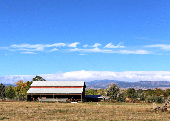
Waves Over the Rockies
These spectacular wave-like clouds are the result of the Kelvin-Helmholtz instability. When two layers of air move past one another at different velocities, an unstable shear layer forms at their interface. Disturbances in this shear layer grow exponentially, creating these short-lived overturning waves that quickly turn turbulent. The strong resemblance of these clouds to breaking ocean waves is no coincidence–the Kelvin-Helmholtz instability occurring between the wind and water is what generates many ocean waves. Kelvin-Helmholtz patterns are also common on other planets, like Jupiter, Saturn, and Mars. (Image credit: Breckenridge Resort; submitted by jshoer)