Tag: wind shear

  • Wave Clouds in the Front Range

    Wave Clouds in the Front Range

    Last Sunday night metro Denver was treated to a rare sight: clouds resembling breaking waves formed near sunset. These are Kelvin-Helmholtz clouds, and the comparison to ocean waves is apt, since the same physics is behind both. Winds were unusually calm near the ground Sunday night, but strong winds blew at the altitude just above the lower cloud layer. That velocity difference created strong shear where the two air layers met. With the cloud layer in place to differentiate the slower-moving air from the faster, we can what’s normally invisible: how the two air layers mix.

    The Denver Post has several more views of the wave clouds from around the area, and you can learn lots more about the Kelvin-Helmholtz instability here. (Image credit: R. Fields; via the Denver Post)

  • Swirling Pollen

    Swirling Pollen

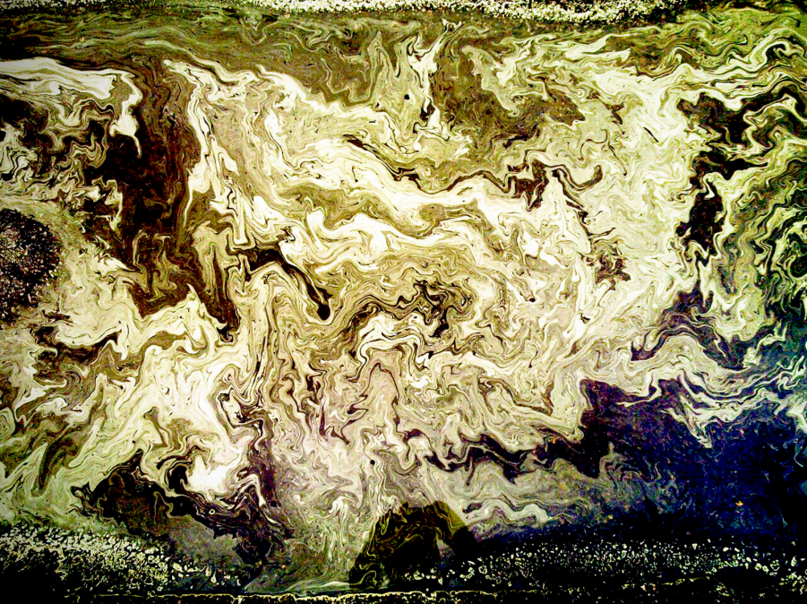
    This photo captures the chaotic mixing present in a simple puddle. Pine pollen strewn across the puddle’s surface acts as tracer particles, revealing some of the motion of the underlying water. As wind blows across the puddle, it moves the water through the formation of ripples and by shearing the surface. That deformation on the top of the puddle will cause further motion beneath the surface. With time and changing wind direction, the resulting pattern of flow can be very complex! (Photo credit: K. Jensen, original)

  • Measuring Wind Speed by Satellite

    Measuring Wind Speed by Satellite

    Weather modeling and forecasting in recent decades have benefited enormously from the availability of more data. For example, satellites now measure wind speeds over the open ocean, instead of data simply coming from isolated ships and buoys.  The satellites do this by measuring the roughness of the ocean using radar or GPS signals bounced off the ocean surface. From this researchers can construct a map of wave height and direction like the one in the animation above. For a large body of water, waves are primarily generated by wind shearing the water at the interface. The waves we see are a result of the Kelvin-Helmholtz instability between the wind and ocean. Because this is a well-known behavior, it is possible to connect the waves we observe with the wind conditions that must have generated them. (Image credit: ESA; animation credit: Wired; submitted by jshoer)

  • Featured Video Play Icon

    Supercell Timelapse

    The storm chasing group Basehunters captured this stunning timelapse of a supercell thunderstorm forming in Wyoming. This class of storm is characterized by the presence of a mesocyclone, seen here as a large, rotating cloud. These rotating features form when horizontal wind shear is redirected upright by an updraft. This requires a strong updraft, which is often formed by a capping inversion, where a layer of warm air traps colder air beneath it. Supercells can be very dangerous in their own right, releasing torrential rains and large hail, but they are also capable of spawning violent tornadoes. (Video credit: Basehunters; via Bad Astronomy; submitted by jshoer)

  • Featured Video Play Icon

    Supercell Thunderstorm

    Photographer Mike Olbinski has captured a spectacular timelapse of a supercell thunderstorm over the plains of Texas. Supercells are characterized by a strong, rotating updraft known as a mesocyclone, seen clearly in the video. These storms are commonly isolated occurrences, forming when horizontal vorticity in the form of wind shear is redirected upwards by an updraft. Such a strong updraft is typically created by a capping inversion, a situation where a layer of warmer air traps the colder air beneath it. (This is why one sees a distinctive cut-off at the top of some clouds.) As warm air rises from the surface, either the air above the cap will cool or the air below the cap will warm. Either situation results in an instability with cooler air on top of warmer air, providing a catalyst for the kind of dramatic weather seen here. (Video credit: M. Olbinski; via io9)